- Old Noarlunga, South Australia
-
Old Noarlunga
Adelaide, South AustraliaPopulation: 1,252 (2006 Census)[1] Established: 1840 Postcode: 5168 Location: 30 km (19 mi) from Adelaide LGA: City of Onkaparinga Suburbs around Old Noarlunga: Seaford Meadows Huntfield Heights Onkaparinga Hills Seaford Old Noarlunga McLaren Vale Seaford Rise Seaford Heights McLaren Vale 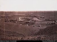 The Horseshoe, Old Noarlunga. Around 1869.
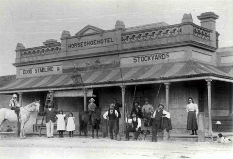
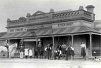 Horseshoe Inn, Old Noarlunga. 1865.
Old Noarlunga is a small town approximately 40 minutes drive south of Adelaide, South Australia. Originally settled around 1840, the town retains its village atmosphere in spite of encroaching suburbia. At the 2006 census, Old Noarlunga had a population of 1,252.[1]
History
In 1850 the South Australia Company laid out the 'No-orlunga Township' at the 'Horseshoe', Onkaparinga River. The name "No-orlunga" supposedly comes from the Kaurna word meaning 'fishing place'[1].
In the early years of settlement, the surrounding area was cleared for wheat farming, and a flour mill was built in the town in 1843 along with wharves used to transport produce down the Onkaparinga River to Port Noarlunga via barge. The town also had a stone bridge across the Onkaparinga, making the town a focal point for travel further down the Fleurieu Peninsula. 1856 saw the formation of the Noarlunga district council.
By the 1860s the town had a post office, council chamber, 6 churches, a public pound, 2 hotels, mill, brewery and brickyard.[2]
Old Noarlunga became a well known sporting venue, visited by cycling clubs and throughout the 20th century the town was a popular stopping point for tourists on the way to beaches in the region.[3]
1972 saw Main South Road bypass the town and in 1978 in took on the name of Old Noarlunga.
Notes
- ^ a b Australian Bureau of Statistics (25 October 2007). "Old Noarlunga (State Suburb)". 2006 Census QuickStats. http://www.censusdata.abs.gov.au/ABSNavigation/prenav/LocationSearch?collection=Census&period=2006&areacode=SSC42216&producttype=QuickStats&breadcrumb=PL&action=401. Retrieved 17 October 2011.
(Coordinates: 35°10′51.05″S 138°30′9.57″E / 35.1808472°S 138.5026583°E)
Suburbs of the City of Onkaparinga Aberfoyle Park · Aldinga · Aldinga Beach · Blewitt Springs · Chandlers Hill · Cherry Gardens · Christie Downs · Christies Beach · Clarendon · Coromandel East · Coromandel Valley · Darlington · Dorset Vale · Flagstaff Hill · Hackham · Hackham West · Happy Valley · Huntfield Heights · Ironbank · Kangarilla · Lonsdale · McLaren Flat · McLaren Vale · Maslin Beach · Moana · Morphett Vale · Noarlunga Centre · Noarlunga Downs · O'Halloran Hill · O'Sullivan Beach · Old Noarlunga · Old Reynella · Onkaparinga Hills · Port Noarlunga · Port Noarlunga South · Port Willunga · Reynella · Reynella East · Seaford · Seaford Heights · Seaford Meadows · Seaford Rise · Sellicks Beach · Sellicks Hill · Tatachilla · The Range · Whites Valley · Willunga · Willunga South · WoodcroftCategories:- Suburbs of Adelaide
- Adelaide geography stubs
- Towns in South Australia

Wikimedia Foundation. 2010.