- Kuelap
-
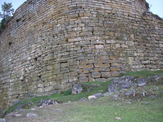
 View along fortress wall at Kuelap
The fortress of Kuelap or Cuélap (Chachapoyas, Amazonas, Perú), associated with the Chachapoyas culture, consists of massive exterior stone walls containing more than four hundred buildings. The structure, situated on a ridge overlooking the Utcubamba Valley in northern Peru, is roughly 600 meters in length and 110 meters in width. It could have been built to defend against the Huari or other hostile peoples however evidence of these hostile groups at the site is minimal. Radiocarbon dating samples show that the structures construction started in the 6th century AD and occupied until the Early Colonial period (1532-1570), however through the pre-Columbian, conquest and colonial periods we have only the four brief references to Kuelap. In lieu of newly discovered documents, there exists no other testimony concerning the site until 1843.
This prime example of Chachapoyan architecture, Kuelap, remained ignored by the outside world until 1843, when Juan Crisóstomo Nieto, a Chachapoyas judge, made a survey of the area and took note of Kuelap's great size, guided by villagers who had known of the site for generations. Subsequently, Kuelap earned the attention of explorers, historians and archaeologists. Notable observers who helped publicize the site included Frenchman Louis Langlois (who wrote a description of Kuelap in the 1930s), Adolph Francis Alphonse Bandelier, Ernst Middendorf, Charles Wiener and Antonio Raimondi.
 The massive walls which protected the fortress.
The ruins of Kuelap are located at the summit of a hill that rises on the left bank of the Utcubamba, having like axis 6°25′07″ LS and 77°55′24″ LOG, according to the engineer Hernán Corbera. Access to Kuelap is gained through El Tingo, a town at approximately 1800m altitude near the bank of the Utcubamba. A horse trail also winds along the left bank of Tingo river and leads eventually up to Marcapampa, a small plain near the site.
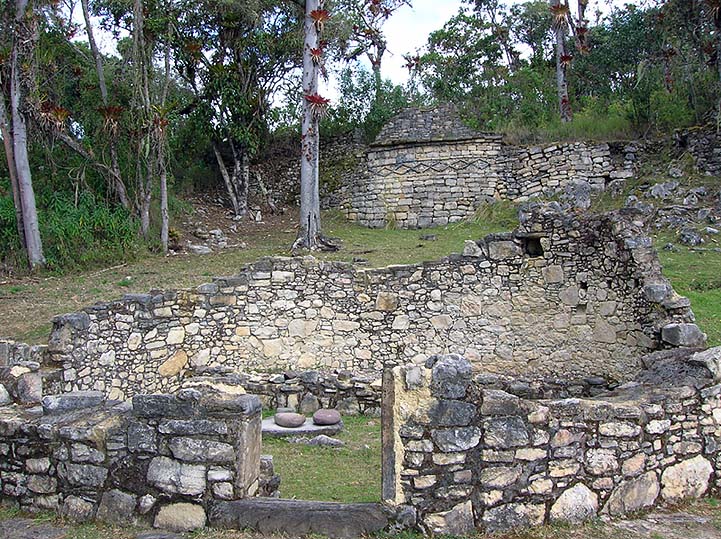
 Remains of ancient buildings in Kuelap.
The monumental ruins of Kuelap are situated at 3000 m above sea level. Judging from its sheer size, Kuelap's construction required considerable effort, rivalling or surpassing other archaeological structures in the Americas in size. The structure is almost 600 m in length and its walls rise up to 19 m in height.
There are multiple levels or platforms within the complex. Because of its extension, these flat elevations support about 400 constructions, most of them cylindrical. From them, only bases remain. In some cases, there are decorated walls with friezes of symbolic content that, in general, seem to evoke eyes and birds that take the form of a letter V in a chain. There are three structures that stand out from the hundreds of others within the complex:
- El Tintero, it is placed in the south end of the biggest anden and it is characterized for being a circular turret in the shape of an inverted cone, a real challenge to the laws of gravity.
- La Atalaya, it is also shaped by a turret, and it is located in the north end of Kuelap.
- El Castillo, it is a construction that is located in the most conspicuous sector of Kuelap and it stands out on the top anden.
 Remains of ancient buildings in Kuelap.
The first level is accessed by three portals, two located on the east or principal frontage; the third one placed on the west.
The best preserved portal and probably the principal one, is located in the south side of the frontispiece. It is 3 m wide at its base and is flanked by high walls, resembling an alleyway. It narrows sharply as it rises, culminating into a space large enough for one person to enter (forming the shape of a pie slice). Scholars believe this was defensive in nature; it has also been speculated that this formation symbolizes an immense vulva. Archaeologists excavated the gateway in 2005/2006 and uncovered a tomb and various designs carved into the blockwork including snakes and heads.
There are other aspects which merit consideration: the colossal construction of Kuelap and the engineering required to provide a sophisticated system of rainwater drainage. At present, because its pipelines are obstructed, the monument has been swelling up. After the big platform is being dilated this way, the wall stones that provide part of the structure are becoming detached. It has not also been clarified how the water supply was carried out; perhaps some of the enclosures that lacked access have served as places where water was reserved. The other enclosures, most of them, should have been food storehouses like the tambos of the Incas, shaping a considerable conglomerate of granaries.
Regarding the function that Kuelap had, there is not also a completely satisfactory response. Popularly it is qualified as "fortress", because of its place and high walls that support its primary level. Adolf Bandelier and especially Louis Langlois tried to demonstrate that Kuelap, was more than a fortress, it might have been a fortified place destined to serve as refuge to the population in emergency situations. They attributed to it, probably by analogy, the same function as medieval European boroughs.
The high walls that veneered the platform and the tightness of the access to the citadel in its final stretch, suggest in effect, that the monument of Kuelap could be constructed for offering a defensive character, or at least, it should have been a place that was protected against intruders. But this possibility does not necessarily annul the others, perhaps of major transcendency.
This way, taking into consideration the function served by the monumental architecture in the Peruvian archaeological past in general, the same one that was related to the socioeconomic needs, it can be concluded that Kuelap could be basically a pre-inca sanctuary. A powerful aristocracy lived in it, whose primary mission was to administer food production and provide religious leadership.
Some time ago, diverse mausoleums were found by accident on the banks of a lagoon known as "Laguna de las Momias" (Mummies' lagoon), located in an inaccessible and uninhabited place of the district of Leimebamba in the province of Chachapoyas. The first exploratory expedition integrated by archaeologists was directed by Federico Kauffmann Doig, in May-June, 1997. Five mausoleums, that were protected by a cave that presents rock paintings, were replete with funeral bundles, objects of ceramics, quipus, etc., attributable to the Chachapoyas culture.
The graves began to be plundered by stockbreeders who sighted them when they were walking around the area of the lagoon. When they realized that the mummies were not presenting any jewelry nor any other adornments of precious metals desisted from pillaging them; this way, about thirty funeral bundles have been saved from the plundering. Such discovery would allow the archaeologists to continue their works to establish new bases of knowledge.
More recently, in July 2010, remains of 79 human bodies dating back to the seventh century were found inside a stone wall believed to have been a secondary grave site, meaning the remains had been removed from their original place, which was a widespread custom in pre-Columbian Peru. Most bone remains found are of adults.
See also
- Iperu, tourist information and assistance
- Tourism in Peru
References
- von Hagen, Adriana. The Chachapoya from the Museo Leymebamba website.
- Presentations made by Kuelap Resident Archaeologist Alfredo Narvez
- Bradley, Robert (2008), "The Architecture of Kuelap", VDM Verlag Dr. Müller
External links
Archaeological sites in Peru  Acaray | Aspero | Bandurria | Buena Vista | Cahuachi | Cajamarquilla | Carajía | Caral | Cerro Pátapo | Chan Chan | Chankillo | Chavín de Huantar | Choquequirao | Coricancha | Cota Coca | Cumbe Mayo | Cusichaca valley | El Brujo | Garagay | Gran Pajáten | Gran Vilaya | Guitarrero Cave | Huaca de la Luna | Huaca del Sol | Huaca Pucllana | Huayna Picchu | Huilcahuain | Incahuasi, Ayacucho | Incahuasi, Cañete | Intihuatana | Jiskairumoko | Kenko | Kuelap | Kuntur Wasi | Llactapata | Machu Picchu | Miculla petroglyphs | Muyucmarca | Ollantaytambo | Pachacamac | Pikillacta | Pikimachay | Piruro | Písac | Puca Pucara | Pumacocha | Puyupatamarca | Qoriwayrachina | Raqchi | Rumicolca | Sacred Valley | Sacsayhuamán | Sayhuite | Sechin, Peru | Sillustani | Sipán | Tambo Colorado | Tambomachay | Tarahuasi | Tipón | Toquepala Caves | Toro Muerto | Túcume | Uchkus–Inkañan | Vilcabamba | Vitcos | Wari ruins | Wiñay Wayna | YanacaCategories:
- Archaeological sites in Peru
- Ruins in Peru


Wikimedia Foundation. 2010.