- Dozier, North Carolina
-
Dozier — Unincorporated community — Location within the state of North Carolina
 Dozier
Coordinates: 36°11′31″N 80°24′22″W / 36.19194°N 80.40611°WCoordinates: 36°11′31″N 80°24′22″W / 36.19194°N 80.40611°W Country United States State North Carolina County Forsyth Time zone Eastern (EST) (UTC-5) – Summer (DST) EDT (UTC-4) ZIP codes FIPS code GNIS feature ID Dozier is an unincorporated community located in Forsyth County, North Carolina not far from the Yadkin River. It is mostly centered at the junction of Vienna-Dozier Road and Waller Road.
Municipalities and communities of Forsyth County, North Carolina Cities 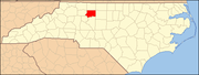
Towns Bethania | Kernersville‡ | King‡ | Lewisville | Rural Hall | Walkertown
Villages Townships Abbots Creek | Belews Creek | Bethania | Broadbay | Clemmonsville | Kernersville | Lewisville | Middle Fork | Old Richmond | Old Town | Salem Chapel | South Fork | Vienna | Winston
Unincorporated
communitiesBelews Creek | Donnaha | Dozier | Germanton | Horneytown | Pfafftown | Seward | Stanleyville | Union Cross | Vienna
Footnotes ‡This populated place also has portions in an adjacent county or counties
Categories:- Populated places in Forsyth County, North Carolina
- Unincorporated communities in North Carolina
- North Carolina geography stubs


Wikimedia Foundation. 2010.