- Ottawa Township, Putnam County, Ohio
-
Ottawa Township, Ohio — Township — Location of Ottawa Township in Putnam County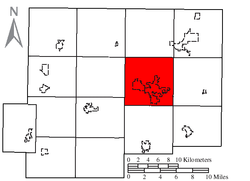
Coordinates: 41°1′28″N 84°2′43″W / 41.02444°N 84.04528°WCoordinates: 41°1′28″N 84°2′43″W / 41.02444°N 84.04528°W Country United States State Ohio County Putnam Area – Total 36.3 sq mi (93.9 km2) – Land 36.2 sq mi (93.8 km2) – Water 0.1 sq mi (0.1 km2) Elevation[1] 709 ft (216 m) Population (2000) – Total 7,961 – Density 219.8/sq mi (84.9/km2) Time zone Eastern (EST) (UTC-5) – Summer (DST) EDT (UTC-4) ZIP code 45875 Area code(s) 419 FIPS code 39-58996[2] GNIS feature ID 1086864[1] Ottawa Township is one of the fifteen townships of Putnam County, Ohio, United States. The 2000 census found 7,961 people in the township, 2,675 of whom lived in the unincorporated portions of the township.[3]
Contents
Geography
Located in the central part of the county, it borders the following townships:
- Liberty Township - north
- Van Buren Township - northeast corner
- Blanchard Township - east
- Riley Township - southeast corner
- Pleasant Township - south
- Union Township - southwest
- Greensburg Township - west
- Palmer Township - northwest corner
Two villages are located in central Ottawa Township: Ottawa, the largest village in and county seat of Putnam County; and Glandorf, which lies northwest of Ottawa.
Name and history
It is the only Ottawa Township statewide.[4]
Government
The township is governed by a three-member board of trustees, who are elected in November of odd-numbered years to a four-year term beginning on the following January 1. Two are elected in the year after the presidential election and one is elected in the year before it. There is also an elected township fiscal officer,[5] who serves a four-year term beginning on April 1 of the year after the election, which is held in November of the year before the presidential election. Vacancies in the fiscal officership or on the board of trustees are filled by the remaining trustees.
References
- ^ a b "US Board on Geographic Names". United States Geological Survey. 2007-10-25. http://geonames.usgs.gov. Retrieved 2008-01-31.
- ^ "American FactFinder". United States Census Bureau. http://factfinder.census.gov. Retrieved 2008-01-31.
- ^ Putnam County, Ohio — Population by Places Estimates Ohio State University, 2007. Accessed 15 May 2007.
- ^ "Detailed map of Ohio" (PDF). United States Census Bureau. 2000. http://www2.census.gov/geo/maps/general_ref/cousub_outline/cen2k_pgsz/oh_cosub.pdf. Retrieved 2007-02-16.
- ^ §503.24, §505.01, and §507.01 of the Ohio Revised Code. Accessed 4/30/2009.
External links
Municipalities and communities of Putnam County, Ohio Villages Belmore | Cloverdale | Columbus Grove | Continental | Dupont | Ft. Jennings | Gilboa | Glandorf | Kalida | Leipsic | Miller City | Ottawa | Ottoville | Pandora | West Leipsic

Townships Unincorporated
communitiesCategories:- Townships in Putnam County, Ohio

Wikimedia Foundation. 2010.