- Neches, Texas
-
Neches — Unincorporated community — Location within the state of Texas
 Neches
Coordinates: 31°52′01″N 95°29′45″W / 31.86694°N 95.49583°WCoordinates: 31°52′01″N 95°29′45″W / 31.86694°N 95.49583°W Country United States State Texas County Anderson Time zone Central (CST) (UTC-6) – Summer (DST) CDT (UTC-5) ZIP codes 75779 FIPS code GNIS feature ID 1363629 Neches is an unincorporated community in east central Anderson County, in the U.S. state of Texas. It has a population of approximately 175.
The Neches Independent School District serves area students.
Post Office
Neches Post Office, 100 FM 2574, Neches, Texas 75779-9998
External links
- Handbook of Texas Online article
- U.S. Geological Survey Geographic Names Information System: Neches, Texas
Municipalities and communities of Anderson County, Texas City 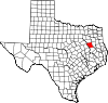
Towns Unincorporated
communitiesBois d'Arc | Cayuga | Montalba | Neches | Slocum | Tennessee Colony
Ghost town Categories:- East Texas geography stubs
- Unincorporated communities in Texas
- Populated places in Anderson County, Texas


Wikimedia Foundation. 2010.