- Butaritari
-
 Butaritari Atoll
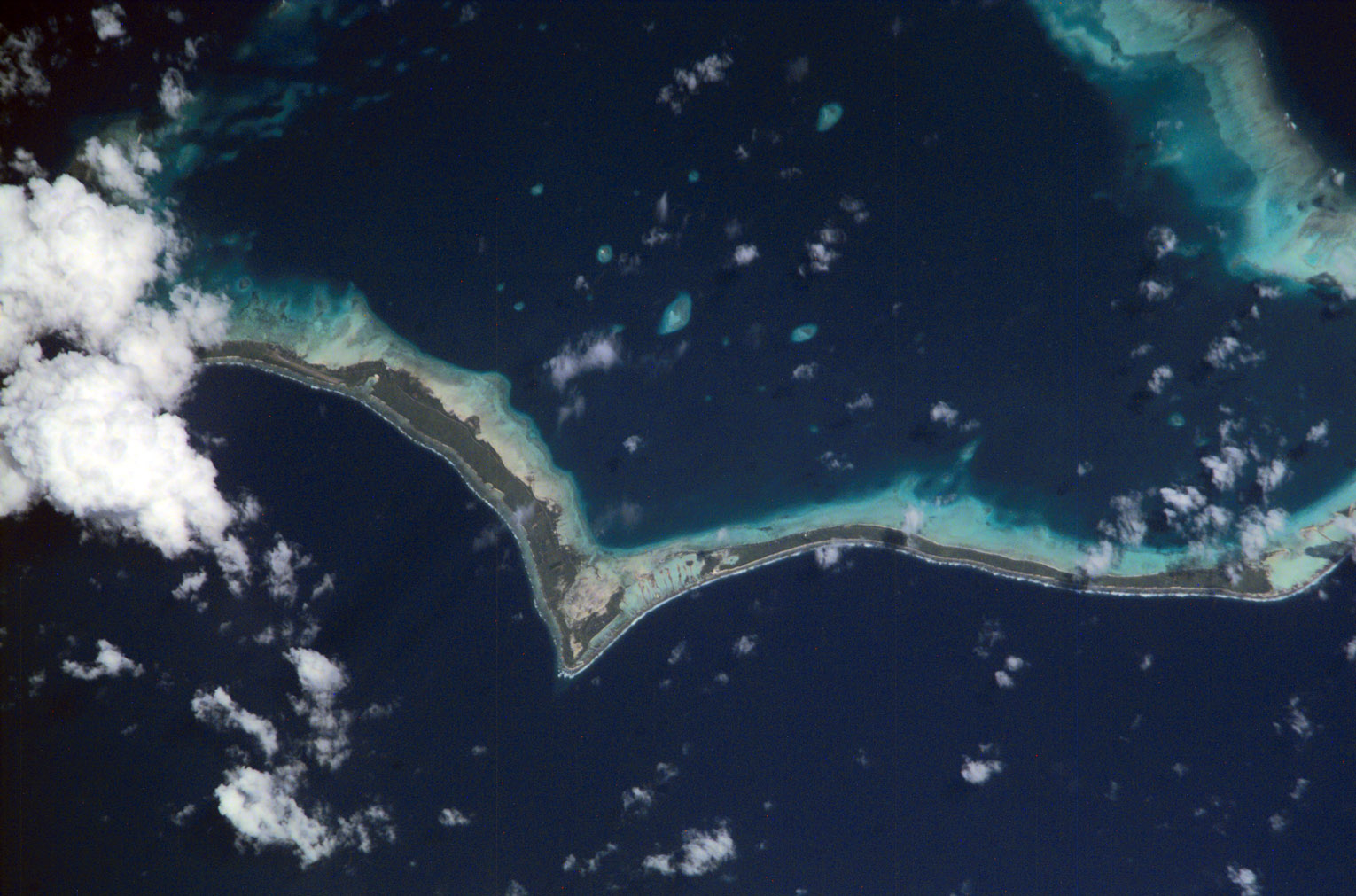
 Butaritari Atoll and part of Makin (upper right). Most of Makin is missing from this map and only a portion is visible.
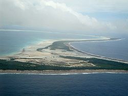 The causeway connecting Tanimaiaki and KeueaMain article: Kiribati
Butaritari (previously known as Makin, Pitt Island, Taritari Island, or Touching Island) is an atoll located in the Pacific Ocean island nation of Kiribati.
Contents
Geography
Three kilometers to the northeast is Makin. Butaritari was called Makin Atoll by the U.S. military, and Makin was then known as Makin Meang or Little Makin to distinguish it. Now that Butaritari has become the preferred name for the larger atoll, speakers tend to drop the qualifier for Makin.
Butaritari atoll has a land area of 13.6 km² and a population of 4,200 as of 2002[update].
The atoll is roughly four-sided and nearly 30 km across in the east west direction, and averages about 15 km north to south. The reef is more submerged and broken into several broad channels along the west side. Small islets are found on reef sections between these channels. The atoll reef is continuous but almost without islets along the north side. In the northeast corner, the reef is some 1.75 km across and with only scattered small islet development. Thus, the lagoon of Butaritari is very open to exchange with the ocean. The lagoon is deep and can accommodate large ships, though the entrance passages are relatively narrow.
The south and southeast portion of the atoll comprises a nearly continuous islet, broken only by a single, broad section of interislet reef. These islets are mostly between 0.2 and 0.5 km across, but widen in the areas where the reef changes directions. Mangrove swamps appear well developed in these latter areas as well as all along the southern lagoon shore. Narrow islets are somewhat characteristic of Kiribati atolls running east-west.
Bikati and Bikatieta islets occupy a corner of the reef at the extreme northwest tip of the atoll, bordering what may be a second small lagoon to the north of the main lagoon. Larger Bikati (2 by 0.5 km) harbors a village. The main village is Butaritari, population approximately 2,000.
Settlements
Butaritari, Keuea, Kuma, Tanimaiaki, Tekabetete
Climate
It is one of the lushest of the "outer islands" due to good rainfall. Typical annual rainfall is about 4 m, compared with about 2 m on Tarawa Atoll and 1 m in the far south of Kiribati. Rainfall on Butaritari is enhanced during an El Niño.
History
 Main article: Gilbert Islands
Robert Louis Stevenson, Fanny Vandegrift Stevenson and Lloyd Osbourne visited Butaritari from 14 July 1889 to early August. At this time Nakaeia, was the ruler of Butaritari and Makin, atolls, his father being Tebureimoa and his grandfather being Tetimararoa. Nakaeia was described by Stevenson as “a fellow of huge physical strength, masterful, violent … Alone in his islands it was he who dealt and profited; he was the planter and the merchant” with his subjects toiling in servitude and fear.[1]
Nakaeia allowed two San Francisco trading firms to operate, Messrs, Crawford and Messrs. Wightman Brothers, with up to 12 Europeans resident on various of the atolls. The presence of the Europeans, and the alcohol they traded to the islanders, resulted in periodic alcoholic binges that only ended with Nakaeia making tapu (forbidding) the sale of alcohol. During the 15 or so days Stevenson spent on Butaritari the islanders were engaged in a drunken spree that threatened the safety of Stevenson and his family. Stevenson adopted the strategy of describing himself as the son of Queen Victoria so as to ensure that he would be treated as a person who should not be threatened or harmed.[2]
Any possible Guano Islands Act claim by the United States to Butaritari and Little Makin was renounced in the 1970s. The islands were visited as part of the United States Exploring Expedition in 1841.
1870–1914
The earliest trading companies on Butaritari were the Hamburg-based DPHG with Pacific headquarters in Samoa, and On Chong (Chinese traders with Australian connections via the goldfields). These traders helped Butaritari became the commercial and trading capital of the Gilbert Islands until Burns Philp, a powerful trading company, moved to Tarawa, following the seat of political power.
1914–1941
Establishment of the Japanese trading company (Nanyo Boeki Kabushiki Kaisha) in Butaritari Village. Gradual decline of On Chong through the 1920s with low copra prices. Takeover of On Chong by WR Carpenter based in Rabaul.
World War II
Japanese invasion
On 10 December 1941, three days after the attack on Pearl Harbor, 300 Japanese troops, plus laborers of the "Gilberts Invasion Special Landing Force" arrived off Makin Atoll and occupied without resistance. Lying east of the Marshall islands, Makin would make an excellent seaplane base, extending Japanese air patrols closer to Howland Island, Baker Island, Tuvalu and Phoenix and Ellice Islands, all held by the Allies and protecting the eastern flank of the Japanese perimeter from an Allied attack.
American raid
Butaritari atoll was the site of the Makin Raid in August 1942, when two companies of the 2nd Marine Raider Battalion landed from the submarines USS Argonaut and USS Nautilus, as a feint to draw Japanese attention away from the planned invasion route through the Solomons. While they annihilated the local garrison, they failed in their initial objectives of taking prisoners and gathering intel.
American invasion
Main article: Battle of MakinSee also: Ukiangong PointOn the eve of invasion, the Japanese garrison consisted of 806 men. Most were of aviation or Japanese and Korean labor units who had little or no combat training and were not assigned weapons or a battle station, and the number of trained combat troops on Makin was no more than 300 soldiers. The garrison also included three tanks and three 37mm anti-tank guns.
Butaritari's land defenses were centered around the lagoon shore, near the seaplane base in the central part of the island. A series of strongpoints was established along Butaritari's ocean side as the Japanese expected the invasion to come from there, following the example of the earlier raid of 1942. Without aircraft, ships, or hope of reinforcement or relief, the outnumbered and outgunned defenders could only hope to delay the coming American attack for as long as possible.
American air operations began on November 13, 1943, followed by bombardment from fire support ships. Troops began to go ashore on November 20, and the attacking troops knocked out the fortified strongpoints one by one. Despite its great superiority in men and weapons, the Americans had considerable difficulty subduing the island's small defensive force. On November 23 the force commander reported "Makin taken."
As compared to an estimated 395 Japanese and Koreans killed in action, American combat casualties numbered 66 killed and 152 wounded. But when the American losses incurred during the sinking of the escort carrier USS Liscome Bay on November 24 by a Japanese submarine are included, the loss balance tips toward the other side. Counting the 687 sailors who went down with the carrier, American casualties exceeded the strength of the entire Japanese garrison on Makin.
Current affairs
The runway on Butaritari has been extended to the full length of the old WW2 American strip (Starman Field) its length can be found in the Sea Bee's historical holdings in Ca.(about 5,000 feet?) and a service with a route of Tarawa Atoll–Butaritari–Majuro operated for a short period in 1995. The aim was to facilitate the development of a strong cash crop economy on the island and link the Marshall Islands with Kiribati. Unfortunately with the demise of Air Nauru (Our airline) in 2008, the only international air connection left over is through Fiji.
The central line of the total solar eclipse of 22 July 2009 ran straight over the island. The eclipse was well observed, despite some minor haziness of the sky.
External links
- USS Makin Island - U.S. Navy for ships named for the island
- Exhibit: The Alfred Agate Collection: The United States Exploring Expedition, 1838-1842 from the Navy Art Gallery
- List of Guano Island claims
- Stevenson, Robert L. (1896), In the South Seas
- http://www.janeresture.com/butaritari/index.htm - Republic
- http://www.factmonster.com/ce6/world/A0809615.html - Facts
- http://www.pacificislandtravel.com/kiribati/about_destin/butaritari.html - Main Info
References
Coordinates: 3°10′04″N 172°49′33″E / 3.16778°N 172.82583°E
Categories:- Islands of Oceania
- Gilbert Islands
- Kiribati geography stubs
- Atolls of Kiribati
- Islands of Kiribati
- Islands claimed under the Guano Islands Act


Wikimedia Foundation. 2010.