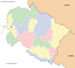
- Mohanpur Mohammadpur
-
Mohanpur Mohammadpur — city — Coordinates 29°47′N 77°58′E / 29.78°N 77.97°ECoordinates: 29°47′N 77°58′E / 29.78°N 77.97°E Country India State Uttarakhand District(s) Haridwar Population 8,700 (2001[update]) Time zone IST (UTC+05:30) Area
• 240 metres (790 ft)
Mohanpur Mohammadpur (Hindi: मोहनपुर मोहम्मदपुर) is a census town in Haridwar district in the Indian state of Uttarakhand.
Geography
Mohanpur Mohammadpur is located at 29°47′N 77°58′E / 29.78°N 77.97°E.[1] It has an average elevation of 240 metres (787 feet).
Demographics
As of 2001[update] India census,[2] Mohanpur Mohammadpur had a population of 8700. Males constitute 52% of the population and females 48%. Mohanpur Mohammadpur has an average literacy rate of 68%, higher than the national average of 59.5%: male literacy is 75%, and female literacy is 59%. In Mohanpur Mohammadpur, 14% of the population is under 6 years of age.
References
- ^ Falling Rain Genomics, Inc - Mohanpur Mohammadpur
- ^ "Census of India 2001: Data from the 2001 Census, including cities, villages and towns (Provisional)". Census Commission of India. Archived from the original on 2004-06-16. http://web.archive.org/web/20040616075334/http://www.censusindia.net/results/town.php?stad=A&state5=999. Retrieved 2008-11-01.
Cities and towns in Haridwar district Haridwar Bahadrabad · BHEL Ranipur · Dhandera · Haridwar · Jhabrera · Laksar · Landhaura · Manglaur · Mohanpur Mohammadpur · Roorkee · Roorkee Cantonment
Cities and towns
in other districtsAlmora · Bageshwar · Chamoli · Champawat · Dehradun · Nainital · Pauri Garhwal · Pithoragarh · Rudraprayag · Tehri Garhwal · Udham Singh Nagar · Uttarkashi
Categories:- Cities and towns in Haridwar district
- Uttarakhand geography stubs
Wikimedia Foundation. 2010.


