Marhaura

Marhaura
Marhaura
—  town  —
Marhaura
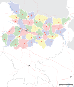
Location of Marhaura
in Bihar and India
Coordinates 25°58′N 84°52′E / 25.97°N 84.87°E / 25.97; 84.87Coordinates: 25°58′N 84°52′E / 25.97°N 84.87°E / 25.97; 84.87
Country India
State Bihar
District(s) Saran
Parliamentary constituency Saran
Assembly constituency Marhaura
Population 24,534 (2001)
Time zone IST (UTC+05:30)
Area

Elevation


52 metres (171 ft)

Marhaura is a town and a notified area in Saran district in the Indian state of Bihar.

Geography

Marhaura is located at 25°58′N 84°52′E / 25.97°N 84.87°E / 25.97; 84.87.[1] It has an average elevation of 52 metres (170 feet).

Demographics

As of 2001 India census,[2] Marhaura had a population of 24,534. Males constitute 52% of the population and females 48%. Marhaura has an average literacy rate of 42%, lower than the national average of 59.5%: male literacy is 54%, and female literacy is 29%. In Marhaura, 19% of the population is under 6 years of age.

References

  1. ^ Falling Rain Genomics, Inc - Marhaura
  2. ^ "Census of India 2001: Data from the 2001 Census, including cities, villages and towns (Provisional)". Census Commission of India. Archived from the original on 2004-06-16. http://web.archive.org/web/20040616075334/http://www.censusindia.net/results/town.php?stad=A&state5=999. Retrieved 2008-11-01. 

PATERHI JALAL FOOFBALL CLUB (GVS)Railway coach factory


Wikimedia Foundation. 2010.

Игры ⚽ Поможем написать реферат

Look at other dictionaries:

  • Marhaura — Original name in latin Marhaura Name in other language Marhaura State code IN Continent/City Asia/Kolkata longitude 25.96927 latitude 84.86221 altitude 61 Population 26138 Date 2012 09 06 …   Cities with a population over 1000 database

  • Marhaura (Vidhan Sabha constituency) — Marhaura   Vidhan Sabha constituency   …   Wikipedia

  • Saran district — सारन जिला Location of Saran district in Bihar State …   Wikipedia

  • Saran (Lok Sabha constituency) — Saran Lok Sabha constituency (Hindi: सारण लोक सभा निर्वाचन क्षेत्र) is one of the 40 Lok Sabha (parliamentary) constituencies in Bihar state in eastern India. This constituency came into existence in 2008 as a part of the implementation of… …   Wikipedia

  • List of India-related articles — Articles (arranged alphabetically) related to India or Indian culture include: NOTOC List of India related topics People are listed by their first names. 1231 SGM 3 STR 2002 Gujarat violence 2005 in India ( previous years ) 2004 Indian Ocean… …   Wikipedia

  • Chhapra —   city   …   Wikipedia

  • Siwan district — Siwan Also known as( Bombay of Bihar )is one of the districts of Bihar state, India, and Siwan town is the administrative headquarters of this district. Siwan district is a part of Saran Division. The town is known for its great past especially… …   Wikipedia

  • Saran division — is an administrative geographical unit of Bihar state of India. Chapra is the administrative headquarters of the division. Currently (2005), the division consists of Saran District, also called Chapra District, Siwan District, Gopalganj District …   Wikipedia

  • Dighwara —   town   …   Wikipedia

  • Mairwa —   town   …   Wikipedia

Share the article and excerpts

Direct link
Do a right-click on the link above
and select “Copy Link”