- Broomhill (ward)
-
Broomhill 
Shown within SheffieldDistrict: Sheffield UK Parliament constituency: Sheffield Central Ceremonial county: South Yorkshire Region: Yorkshire and the Humber Population (2001): 16,800 Councillors Shaffaq Mohammed (Liberal Democrats)
Paul Scriven (Liberal Democrats)
Stuart Wattam (Labour Party)Broomhill ward—which includes the districts of Broomhill, Crookesmoor, Endcliffe, and Tapton—is one of the 28 electoral wards in City of Sheffield, England. It is located in the western part of the city and covers an area of 2.7 km2. The population of this ward in 2001 was 16,800 people in 5,700 households. Broomhill ward is one of the five wards that make up the Sheffield Central Parliamentary Constituency.
Contents
History
According to E. Wilkinson: "Most of what is now Broomhill was used as the Crookesmoor Racecourse from 1711 to 1781, the races only being discontinued when the commons of Ecclesall Bierlow were enclosed between 1778 and 1789. Part of Broomhill lay in Nether Hallam, the common land of which was enclosed in 1791. (The parts lying in Nether Hallam are from the north side of Whitham Road to the east side of Crookes Road, and from the bottom of Endcliffe Crescent, Endcliffe Vale Road, Endcliffe Avenue, Oakholme Road, Westbourne Road from below the old Radio Sheffield building and No. 27, Southbourne Road and the north side of Clarkehouse Road from the bottom of Southbourne Road to Brocco Bank.)
There were a few houses within this area, some of them encroachments on the common land, and a huddle of cottages to the east of the present Botanical Gardens, including an inn "The Ball in the Tree", demolished in 1870. The suburb takes its name from the house built by William Newbould on land to the east of Newbould Lane in 1792, to which he gave the name of "Broomhill", for the simple reason that it was the first house above Broomhall, and was on a hill.
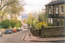 Broomhill, Sheffield (looking East along Beech Hill Rd.)
A few more large houses with considerable grounds were built during the next 30 years, but the real beginning of Broomhill was when the turnpike road to Glossop was opened in 1821. Terraces as well as bigger houses followed the road and the first back-to-back houses were built in Peel Street in 1827. Houses also crept down from Crookes as far as Hoole Road, this area being known as Mount Pisgah, a pun on the biblical reference of Moses viewing the holy land from there, since all the land that could be seen to the east was owned by the Holy family. By the early 1830s Broomhill had five public houses, the Ball, Broomhill Tavern, Fox & Duck, Southseas, and the Travellers Inn, and a few shops. Whilst growth was steady, the 1840s were years of depression and growth only really resumed in the 1850s when the land above and along Fulwood Road was developed. Most of the former household names in the steel and cutlery industry lived or passed through Broomhill, as did many of the founders of the stores in town, brewers, solicitors and medical practitioners. There was always a fairly substantial population of artisans and small shopkeepers, to service the bigger houses. The shopping centre was the best suburban one and probably reached its peak during the second world war when several stores and shops that had been bombed out in the city came to Broomhill, the foremost being John Walsh Ltd., which moved into the Mount.
The district inspired the former poet laureate Sir John Betjeman to write a poem entitled 'An Edwardian Sunday, Broomhill, Sheffield' which draws on the large stone houses, steel industry and hilly landscapes of the city.
Most of the Halls of Residence of the University of Sheffield are in the area, and it is also home to many other students in privately owned accommodation. The name 'Broomhill' is often taken to refer to the parade of shops on Fulwood Road which includes a collection of takeaways, 4 pubs, a Spar supermarket and many other local shops and banks.
Districts of Broomhill ward
Broomhill
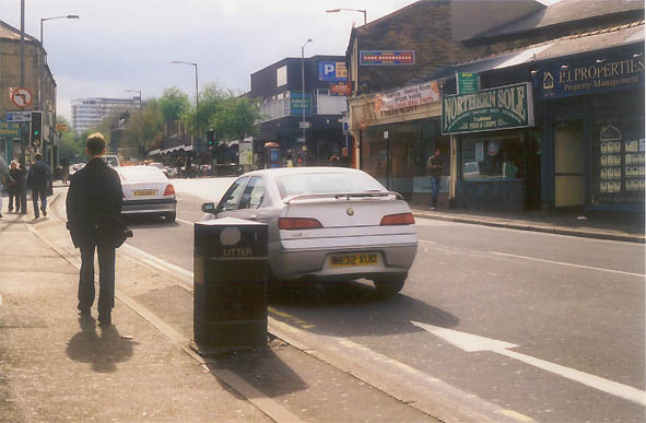
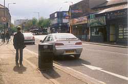 Fulwood Road, Broomhill, Sheffield
Broomhill (grid reference SK333869) is a suburb of western Sheffield, England. Largely developed in the nineteenth century, its prominent buildings include Broomhill Church, The Mount and King Edward VII School, the latter two listed buildings both designed by William Flockton. The area lies west of the main campus of the University of Sheffield and has a large student population, including popular areas such as Parkers Road, and was identified in 2003 as the highest ranking area outside London for overall wealth
The centre of Broomhill is a conservation area, while numerous hospitals and the Sheffield Botanical Gardens lie on its borders. The Yorkshire Ripper, Peter Sutcliffe, was arrested in the area, on Melbourne Avenue, which runs through the middle of Sheffield High School.
Crookesmoor
Crookesmoor (grid reference SK338877) lies immediately north of the University of Sheffield's main campus housing the University's Crookesmoor library, S10 Gym and sports centre, east of Crookes and south of Walkley. A residential area, it consists largely of terraced houses, has a significant student population and is home to Crookes Valley Park which also includes the Dam House. This park contains a lake, the last in what was a chain of reservoirs.[1]
A racecourse lay in Crookesmoor from at least 1711 until 1781, when the land was enclosed. The racecourse had a sizeable grandstand, lying near Fulwood Road.[1]
Endcliffe
Endcliffe (grid reference SK328863) lies south west of Broomhill and north of Hunter's Bar and is a wealthy residential area. It includes Birkdale School (a private school) and part of the "Endcliffe Student Village", containing brand new flats, as well as old halls of residence, all owned by the University of Sheffield. The suburb contains the 36 room mansion Endcliffe Hall built for the steel magnate John Brown in the 1860s.
Tapton
Tapton (grid reference SK322868) lies west of Crookes. It is home to Tapton School and the Tapton Youth Brass Band.
References
External links
- The Broomhill Festival
- The Broomhill Action and Neighbourhood Group
- Tapton Youth Brass Band
- Tapton School
Coordinates: 53°22′36″N 1°30′08″W / 53.376775°N 1.502273°W
The City of Sheffield, England About Sheffield 
Districts of Sheffield by ward Arbourthorne · Beauchief and Greenhill · Beighton · Birley · Broomhill · Burngreave · Central · Crookes · Darnall · Dore and Totley · East Ecclesfield · Ecclesall · Firth Park · Fulwood · Gleadless Valley · Graves Park · Hillsborough · Manor Castle · Mosborough · Nether Edge · Richmond · Shiregreen and Brightside · Southey · Stannington · Stocksbridge and Upper Don · Walkley · West Ecclesfield · WoodhouseCategories:- Districts of Sheffield
- Wards of Sheffield
- Student quarters

Wikimedia Foundation. 2010.