- Danbury Municipal Airport
-
Coordinates: 41°22′18″N 073°28′56″W / 41.37167°N 73.48222°W
Danbury Municipal Airport 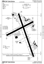
FAA airport diagram IATA: DXR – ICAO: KDXR – FAA LID: DXR Summary Airport type Public Owner City of Danbury Location Danbury, Connecticut Elevation AMSL 458 ft / 140 m Runways Direction Length Surface ft m 8/26 4,422 1,348 Asphalt 17/35 3,135 956 Asphalt Statistics (2007) Aircraft operations 79,282 Based aircraft 227 Source: Federal Aviation Administration[1] Danbury Municipal Airport (IATA: DXR, ICAO: KDXR, FAA LID: DXR) is a public use general aviation airport located three miles (5 km) southwest of the central business district of Danbury, in Fairfield County, Connecticut, United States.[1] The airport opened in 1930. It is currently run by the city of Danbury.
The Reliant Air building burned down on the evening of September 12, 2007. The hangar was located on the northeast side of the airport.[2] It has since been rebuilt and Reliant Air continues in business.
Facilities and aircraft
Danbury Municipal Airport covers 248 acres (1.00 km2) and has two runways:[1]
- Runway 8/26: 4,422 x 150 ft (1,348 x 46 m), Surface: Asphalt
- Runway 17/35: 3,135 x 100 ft (956 x 30 m), Surface: Asphalt
The airport has three instrument approaches:
- Localizer Runway 8: Decision height - 643 feet (196 m) AGL
- VOR or GPS-A: Decision height - 902 feet (275 m) AGL
- GPS Runway 8: Decision height - 802 feet (244 m) AGL
For the 12-month period ending March 31, 2007, the airport had 79,282 aircraft operations, an average of 217 per day: 99% general aviation, <1% air taxi and <1% military. There are 227 aircraft based at this airport: 76% single engine, 21% multi-engine, 1% jet aircraft and 1% helicopters.[1]
References
- ^ a b c d FAA Airport Master Record for DXR (Form 5010 PDF), effective 2007-07-05
- ^ Kevin J. Czarzasty (2007-09-13). "Fire Destroys Hangar at Danbury Airport". FireFightingNews. http://www.firefightingnews.com/articlePSO-US.cfm?articleID=37794. Retrieved 2009-11-14.
External links
- Airport History and Mission Statement at City of Danbury website
- FAA Airport Diagram (PDF), effective 20 October 2011
- Resources for this airport:
- AirNav airport information for KDXR
- ASN accident history for DXR
- FlightAware airport information and live flight tracker
- NOAA/NWS latest weather observations
- SkyVector aeronautical chart, Terminal Procedures for KDXR
Airports in the New York City area Major commercial airports 
Secondary commercial airports General aviation airports Brookhaven • Danbury • Essex County • Linden • Morristown • Republic • Teterboro • Trenton-Mercer • SikorskyHeliports Transportation Categories:- Airports in Connecticut
- Danbury, Connecticut
- Transportation in Fairfield County, Connecticut
- Buildings and structures in Fairfield County, Connecticut
- Northeastern United States airport stubs
- Connecticut building and structure stubs


Wikimedia Foundation. 2010.