- Morristown Municipal Airport
-
Morristown Municipal Airport 
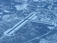
Morristown Municipal Airport seen from a flight departing Newark IATA: MMU – ICAO: KMMU – FAA LID: MMU Summary Airport type Public Operator Town of Morristown Serves Morristown, New Jersey Location Whippany Elevation AMSL 187 ft / 57 m Coordinates 40°47′58″N 074°24′54″W / 40.79944°N 74.415°W Website Runways Direction Length Surface ft m 5/23 5,999 1,828 Asphalt 13/31 3,998 1,219 Asphalt Morristown Municipal Airport (IATA: MMU, ICAO: KMMU, FAA LID: MMU) is a public airport located in Whippany, three miles (5 km) east of the central business district (CBD) of Morristown, in Morris County, New Jersey, USA. It is owned by the town of Morristown and operated by DM AIRPORTS, LTD
Contents
Facilities
Morristown Municipal Airport covers 625 acres (253 ha) and has two runways:
- Runway 5/23: 5,999 x 150 ft (1,828 x 46 m), Surface: Asphalt-Grooved
- Runway 13/31: 3,998 x 150 ft (1,219 x 46 m), Surface: Asphalt-Grooved
FBO's
There are two FBO's on the field: Signature Flight Support FTC FBO
See also
References
- Morristown Municipal Airport (official site)
- FAA Airport Master Record for MMU (Form 5010 PDF)
External links
- FAA Airport Diagram (PDF), effective 20 October 2011
- Resources for this airport:
- AirNav airport information for KMMU
- ASN accident history for MMU
- FlightAware airport information and live flight tracker
- NOAA/NWS latest weather observations
- SkyVector aeronautical chart, Terminal Procedures for KMMU
Categories:- Airports in New Jersey
- Buildings and structures in Morris County, New Jersey
- Transportation in Morris County, New Jersey
- Northeastern United States airport stubs
- New Jersey airport stubs
- New Jersey building and structure stubs
Wikimedia Foundation. 2010.
