- Downtown Manhattan Heliport
-
Downtown Manhattan Heliport 
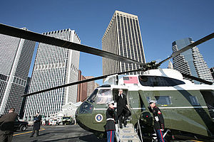
IATA: JRB – ICAO: KJRB – FAA LID: JRB Summary Airport type Public Owner NYCEDC Operator Saker Aviation Services Serves New York City Elevation AMSL 7 ft / 2 m Coordinates 40°42′04″N 74°00′32″W / 40.701116°N 74.008801°WCoordinates: 40°42′04″N 74°00′32″W / 40.701116°N 74.008801°W Website Helipads Number Length Surface ft m H1 62 19 Concrete Statistics (2003) Aircraft operations 10,002 Source: FAA[1] and official site[2]  George W. Bush at the heliport on January 31, 2007
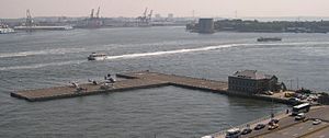
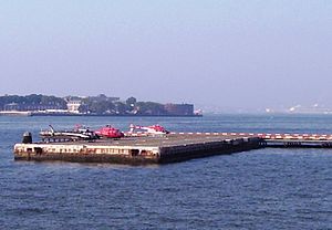
The Downtown Manhattan Heliport (IATA: JRB, ICAO: KJRB, FAA LID: JRB), also known as the Downtown Manhattan/Wall St. Heliport, is a helicopter landing platform at Pier 6 in the East River in Manhattan, New York.
Contents
History
Downtown Manhattan Heliport opened on December 8, 1960, supplementing the existing heliport at West 30th Street which opened in 1956.[3][4] During the 1960s and 1970s, New York Airways provided scheduled service from the heliport to the city's major airports. Scheduled passenger service was discontinued with PanAm's bankruptcy in the mid-1980s. In 2006, US Helicopter resumed scheduled passenger service with hourly flights to John F. Kennedy International Airport until November 2009 as US Helicopter ceased all services.
Much of the heliport's traffic is generated by Wall Street and the lower Manhattan financial district; top business executives and time-sensitive document deliveries often use the heliport. The heliport is also the normal landing spot for the President of the United States on visits to New York. Michael Bloomberg, now mayor of New York, frequently used the heliport to fly between Bloomberg L.P. headquarters and Johns Hopkins University when he was chairman of both institutions.
The Downtown Manhattan Heliport is a public heliport operated by the New York City Economic Development Corporation (NYCEDC) with charter service to Newark Liberty International Airport, Teterboro Airport, Morristown Municipal Airport, and other New York-area airports. Public sightseeing and VIP flights are also common.
Facilities and aircraft
The heliport covers an area of 2 acres (0.81 ha) at an elevation of 7 feet (2 m) above mean sea level. It has one helipad designated H1 with a 62 x 62 ft (19 x 19 m) concrete surface. For the 12-month period ending December 30, 2003, the airport had 10,002 aircraft operations, an average of 27 per day: 90% general aviation and 10% military.[1]
See also
- East 34th Street Heliport
- West 30th Street Heliport
References
- Notes
- ^ a b FAA Airport Master Record for JRB (Form 5010 PDF), effective 2008-04-10
- ^ Downtown Manhattan Heliport, official web site
- ^ "Heliport at Battery Approved by City; Will Open in 1961". The New York Times. May 28, 1960. http://select.nytimes.com/gst/abstract.html?res=F30B15F63E5916738DDDA10A94DD405B808AF1D3. Retrieved 2010-08-26.
- ^ "Port Agency Opens 2d Heliport, Linking Downtown to Airfields". The New York Times. December 9, 1960. http://select.nytimes.com/gst/abstract.html?res=F40D10FE3D541A7A93CBA91789D95F448685F9. Retrieved 2010-08-26.
External links
Airports in the New York City area Major commercial airports 
Secondary commercial airports General aviation airports Brookhaven • Danbury • Essex County • Linden • Morristown • Republic • Teterboro • Trenton-Mercer • SikorskyHeliports Downtown • E 34th St • W 30th StTransportation Port Authority of New York and New Jersey Seaports Airports Bridges and tunnels Rail Bus stations Other Categories:- Airports in New York
- Aviation in New York City
- Transportation in Manhattan
- Port Authority of New York and New Jersey
- Heliports in New York
- 1960 establishments
Wikimedia Foundation. 2010.

