County of Ward, Queensland

County of Ward, Queensland
Ward
Queensland
Ward Qld.PNG
Location within Queensland
Lands administrative divisions around Ward
Churchill Stanley Pacific Ocean
Merivale Ward Pacific Ocean
Buller (NSW) Rous (NSW) Pacific Ocean

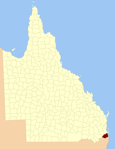
The County of Ward is a county located on the south-east corner of Queensland, Australia. Like all counties in Queensland, it is a non-functional administrative unit, that is used mainly for the purpose of registering land titles.

Ward takes in the south-eastern corner of Queensland, and the main urbanised area within the county is the city of the Gold Coast. It also takes in the southern parts of the West Moreton region centred on Beaudesert and Boonah.[1] The county was officially named and bounded by the Governor in Council on 7 March 1901 under the Land Act 1897.[2]

Contents

Parishes

Like all counties in Queensland, Ward is divided into parishes. The parishes current LGA and mapping coordinates to the approximate centre of each location is as follows:

Parish LGA Coordinates
Albert Gold Coast 27°45′S 153°18′E / 27.75°S 153.3°E / -27.75; 153.3 (Albert Parish)
Alford Scenic Rim 28°10′S 152°33′E / 28.167°S 152.55°E / -28.167; 152.55 (Alford Parish)
Barrow Gold Coast 27°55′S 153°19′E / 27.917°S 153.317°E / -27.917; 153.317 (Barrow Parish)
Beaudesert Scenic Rim 28°02′S 152°59′E / 28.033°S 152.983°E / -28.033; 152.983 (Beaudesert Parish)
Boyd Logan 27°44′S 153°11′E / 27.733°S 153.183°E / -27.733; 153.183 (Boyd Parish)
Bromelton Scenic Rim 27°59′S 152°52′E / 27.983°S 152.867°E / -27.983; 152.867 (Bromelton Parish)
Cedar Gold Coast 27°55′S 153°15′E / 27.917°S 153.25°E / -27.917; 153.25 (Cedar Parish)
Coochin Scenic Rim 28°06′S 152°37′E / 28.1°S 152.617°E / -28.1; 152.617 (Coochin Parish)
Coomera Gold Coast 27°52′S 153°21′E / 27.867°S 153.35°E / -27.867; 153.35 (Coomera Parish)
Currigee Gold Coast 27°50′S 153°26′E / 27.833°S 153.433°E / -27.833; 153.433 (Currigee Parish)
Darlington Gold Coast 27°47′S 153°11′E / 27.783°S 153.183°E / -27.783; 153.183 (Darlington Parish)
Dugandan Scenic Rim 27°55′S 152°47′E / 27.917°S 152.783°E / -27.917; 152.783 (Dugandan Parish)
Gilston Gold Coast 28°04′S 153°21′E / 28.067°S 153.35°E / -28.067; 153.35 (Gilston Parish)
Jimboomba Logan 27°51′S 153°02′E / 27.85°S 153.033°E / -27.85; 153.033 (Jimboomba Parish)
Kerry Scenic Rim 28°08′S 153°03′E / 28.133°S 153.05°E / -28.133; 153.05 (Kerry Parish)
Knapp Scenic Rim 28°07′S 152°48′E / 28.117°S 152.8°E / -28.117; 152.8 (Knapp Parish)
Logan Logan 27°53′S 153°00′E / 27.883°S 153°E / -27.883; 153 (Logan Parish)
Melcombe Scenic Rim 28°13′S 152°37′E / 28.217°S 152.617°E / -28.217; 152.617 (Melcombe Parish)
Moffatt Logan 27°54′S 153°06′E / 27.9°S 153.1°E / -27.9; 153.1 (Moffatt Parish)
Mudgeeraba Gold Coast 28°07′S 153°22′E / 28.117°S 153.367°E / -28.117; 153.367 (Mudgeeraba Parish)
Mundoolun Logan 27°53′S 153°03′E / 27.883°S 153.05°E / -27.883; 153.05 (Mundoolun Parish)
Nerang Gold Coast 27°59′S 153°22′E / 27.983°S 153.367°E / -27.983; 153.367 (Nerang Parish)
Nindooinbah Scenic Rim 28°02′S 153°03′E / 28.033°S 153.05°E / -28.033; 153.05 (Nindooinbah Parish)
Numinbah Gold Coast 28°10′S 153°15′E / 28.167°S 153.25°E / -28.167; 153.25 (Numinbah Parish)
Palen Creek Scenic Rim 28°15′S 152°45′E / 28.25°S 152.75°E / -28.25; 152.75 (Palen Parish)
Pimpama Gold Coast 27°49′S 153°18′E / 27.817°S 153.3°E / -27.817; 153.3 (Pimpama Parish)
Roberts Scenic Rim 28°14′S 153°08′E / 28.233°S 153.133°E / -28.233; 153.133 (Roberts Parish)
Sarabah Scenic Rim 28°06′S 153°07′E / 28.1°S 153.117°E / -28.1; 153.117 (Sarabah Parish)
Tabragalba Scenic Rim 27°59′S 153°07′E / 27.983°S 153.117°E / -27.983; 153.117 (Tabragalba Parish)
Tallebudgera Gold Coast 28°09′S 153°26′E / 28.15°S 153.433°E / -28.15; 153.433 (Tallebudgera Parish)
Tamborine Mountain Scenic Rim 27°54′S 153°08′E / 27.9°S 153.133°E / -27.9; 153.133 (Tamborine Parish)
Tamrookum Scenic Rim 28°04′S 152°48′E / 28.067°S 152.8°E / -28.067; 152.8 (Tamrookum Parish)
Telemon Scenic Rim 28°14′S 152°57′E / 28.233°S 152.95°E / -28.233; 152.95 (Telemon Parish)
Teviot Scenic Rim 27°53′S 152°56′E / 27.883°S 152.933°E / -27.883; 152.933 (Teviot Parish)
Wickham Logan 27°49′S 153°08′E / 27.817°S 153.133°E / -27.817; 153.133 (Wickham Parish)
Witheren Scenic Rim 28°04′S 153°11′E / 28.067°S 153.183°E / -28.067; 153.183 (Witheren Parish)

References

  1. ^ Moreton District, County of Ward Maps - A5 Series at Queensland Archives.
  2. ^ Department of Environment and Resource Management. "Place name details — Ward". http://www.derm.qld.gov.au/property/placenames/details.php?id=36551. Retrieved 4 June 2011. 

See also

External links

Coordinates: 27°55′S 153°10′E / 27.917°S 153.167°E / -27.917; 153.167


Wikimedia Foundation. 2010.

Игры ⚽ Поможем сделать НИР

Look at other dictionaries:

  • County of Stanley, Queensland — Map of all coordinates from Google Map of all coordinates from Bing Export all coordinates as KML …   Wikipedia

  • County of Churchill, Queensland — Churchill Queensland Location within Queensland Lands administrative divisions around …   Wikipedia

  • Ward County (disambiguation) — Ward County is the name of several counties in the United States:* Ward County, North Dakota * Ward County, TexasAlso a cadastral unit in Queensland, Australia:* County of Stanley, Queensland …   Wikipedia

  • Ward County — may refer to: Ward County, North Dakota Ward County, Texas Ward County, Queensland This disambiguation page lists articles about distinct geographical locations with the same name. If an internal link …   Wikipedia

  • Cadastral divisions of Queensland — refers to the divisions of Queensland used for the registration of land titles. There are 322 counties, and 5,319 parishes within the state. [http://www.nrw.qld.gov.au/museum/articles complete/mapping/cad.html] . They are part of the cadastral… …   Wikipedia

  • County Armagh — Contae Ard Mhacha Coontie Airmagh / Armagh Coat of arms …   Wikipedia

  • County of Hawke — was a 19th century parliamentary electorate in the Hawke s Bay region of New Zealand in the 2nd New Zealand Parliament in 1860.[1] History In 1858 the General Assembly made some significant changes to electoral boundaries[2] and increased… …   Wikipedia

  • County of Merivale — Merivale Queensland Location within Queensland Lands administrative divisions around Mer …   Wikipedia

  • Townsville, Queensland — Infobox Australian Place | type = city name = Townsville state = qld caption = The CBD from Palmer Street, South Townsville Castle Hill in the background pop = 143,328Census 2006 AUS|id=3057|name=Townsville (QLD) (Statistical… …   Wikipedia

  • Lands administrative divisions of Queensland — The 319 counties of Queensland in 1901. Lands administrative divisions of Queensland refers to the divisions of Queensland used for the registration of land titles. There are 322 counties, and 5,319 parishes within the state.[1]. They are part of …   Wikipedia

Share the article and excerpts

Direct link
Do a right-click on the link above
and select “Copy Link”