- County of Merivale
-
Merivale
Queensland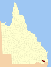
Location within QueenslandLands administrative divisions around Merivale Derby Aubigny Churchill Marsh Merivale Ward Bentinck Buller (NSW) Rous (NSW) The County of Merivale is a county located on the southern boundary of the state of Queensland, Australia. Like all counties in Queensland, it is a non-functional administrative unit, that is used mainly for the purpose of registering land titles. The county was named in honour of Herman Merivale, the British permanent Under-Secretary of State for the Colonies. Its boundaries were declared and made subject to the Land Act 1897 on 7 March 1901.[1] Population centres within the County of Merivale include the towns of Warwick, Allora and Killarney.[2]
Parishes
See also
References
- ^ "Place name details: Merivale". Queensland Government (Department of Environment and Resource Management). 4 March 2008. http://www.derm.qld.gov.au/property/placenames/detail.php?id=21641. Retrieved 10 June 2011.
- ^ Darling Downs District, County of Merivale Maps - C1 Series at Queensland Archives.
Categories:- Counties of Queensland
- Queensland geography stubs

Wikimedia Foundation. 2010.