Menindee County

Menindee County
Menindee
New South Wales
Menindee NSW.PNG
Location in New South Wales
Lands administrative divisions around Menindee
South Australia Yancowinna Tandora
South Australia Menindee Livingstone
South Australia Windeyer Perry

Menindee County is one of the 141 Cadastral divisions of New South Wales. It is located between the Darling River and the South Australian border. Menindee is at its north-eastern edge. The Menindee Lakes are located there.

The name Menindee is of unknown origin.[1]

Parishes within this county

A full list of parishes found within this county; their current LGA and mapping coordinates to the approximate centre of each location is as follows:

Parish LGA Coordinates
Bintullia Unincorporated 32°4032S 142°1108E / 32.67556°S 142.18556°E / -32.67556; 142.18556 (Bintullia)
Buckalow East Unincorporated 32°3822S 141°1512E / 32.63944°S 141.25333°E / -32.63944; 141.25333 (Buckalow East)
Buckalow West Unincorporated 32°3351S 141°0500E / 32.56417°S 141.0833333°E / -32.56417; 141.0833333 (Buckalow West)
Buckalow Unincorporated 32°3335S 141°1343E / 32.55972°S 141.22861°E / -32.55972; 141.22861 (Buckalow)
Burta Unincorporated 32°3000S 141°0459E / 32.5°S 141.08306°E / -32.5; 141.08306 (Burta)
Caari Unincorporated 32°2907S 141°4834E / 32.48528°S 141.80944°E / -32.48528; 141.80944 (Caari)
Cawndilla Central Darling Shire 32°2728S 142°1124E / 32.45778°S 142.19°E / -32.45778; 142.19 (Cawndilla)
Coonalhugga Central Darling Shire 32°4136S 142°1944E / 32.69333°S 142.32889°E / -32.69333; 142.32889 (Coonalhugga)
Coultra Unincorporated 32°1535S 141°0404E / 32.25972°S 141.06778°E / -32.25972; 141.06778 (Coultra)
Doon Unincorporated 32°2027S 141°1256E / 32.34083°S 141.21556°E / -32.34083; 141.21556 (Doon)
Enmore Unincorporated unknown
Ita Unincorporated 32°3933S 141°2612E / 32.65917°S 141.43667°E / -32.65917; 141.43667 (Ita)
Kinchega Central Darling Shire 32°3107S 142°1939E / 32.51861°S 142.3275°E / -32.51861; 142.3275 (Kinchega)
Laidley Central Darling Shire 32°2510S 142°1807E / 32.41944°S 142.30194°E / -32.41944; 142.30194 (Laidley)
Mitta Unincorporated 32°4156S 142°0007E / 32.69889°S 142.00194°E / -32.69889; 142.00194 (Mitta)
Mundybah Unincorporated 32°1953S 141°5544E / 32.33139°S 141.92889°E / -32.33139; 141.92889 (Mundybah)
Naloira Central Darling Shire 32°3422S 142°2032E / 32.57278°S 142.34222°E / -32.57278; 142.34222 (Naloira)
Nettlegoe Unincorporated 32°3310S 142°0055E / 32.55278°S 142.01528°E / -32.55278; 142.01528 (Nettlegoe)
Paringi Unincorporated 32°2203S 142°0806E / 32.3675°S 142.135°E / -32.3675; 142.135 (Paringi)
Perry Central Darling Shire 32°2055S 142°2131E / 32.34861°S 142.35861°E / -32.34861; 142.35861 (Perry)
Pinnelco Central Darling Shire 32°3741S 142°1837E / 32.62806°S 142.31028°E / -32.62806; 142.31028 (Pinnelco)
Putta Unincorporated 32°2528S 141°1203E / 32.42444°S 141.20083°E / -32.42444; 141.20083 (Putta)
Rantyga Unincorporated 32°1809S 141°3613E / 32.3025°S 141.60361°E / -32.3025; 141.60361 (Rantyga)
Tandou Central Darling Shire 32°3232S 142°1205E / 32.54222°S 142.20139°E / -32.54222; 142.20139 (Tandou)
Waneba Unincorporated 32°3708S 141°3728E / 32.61889°S 141.62444°E / -32.61889; 141.62444 (Waneba)
Wanga Unincorporated 32°2605S 141°1854E / 32.43472°S 141.315°E / -32.43472; 141.315 (Wanga)
Wendi Unincorporated 32°3019S 141°3555E / 32.50528°S 141.59861°E / -32.50528; 141.59861 (Wendi)
West Mitta Unincorporated 32°4044S 141°4833E / 32.67889°S 141.80917°E / -32.67889; 141.80917 (West Mitta)
West Wendi Unincorporated 32°2559S 141°2709E / 32.43306°S 141.4525°E / -32.43306; 141.4525 (West Wendi)

References

  1. ^ Geographical Names Board of NSW

Wikimedia Foundation. 2010.

Игры ⚽ Поможем написать реферат

Look at other dictionaries:

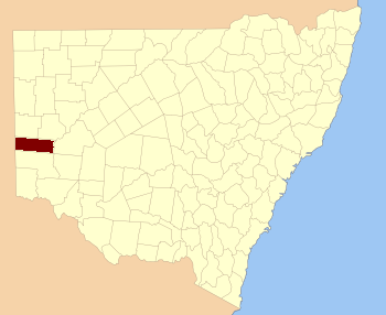
  • Menindee County, New South Wales — Infobox Australian cadastral name = Menindee state = New South Wales caption = Location in New South Wales near nw = South Australia near n = Yancowinna near ne = Tandora near e = Livingstone near se = Perry near s = Windeyer near sw = South… …   Wikipedia

  • Tandora County, New South Wales — Infobox Australian cadastral name = Tandora state = New South Wales caption = Location in New South Wales near nw = Mootwingee near n = Mootwingee near ne = Young near e = Livingstone near se = Livingstone near s = Menindee near sw = Menindee… …   Wikipedia

  • Tandora County — Map of all coordinates from Google Map of all coordinates from Bing Export all coordinates as KML …   Wikipedia

  • Livingstone County, New South Wales — Map of all coordinates from Google Map of all coordinates from Bing Export all coordinates as KML …   Wikipedia

  • Yancowinna County, New South Wales — Infobox Australian cadastral name = Yancowinna state = New South Wales caption = Location in New South Wales near nw = South Australia near n = Farnell near ne = Mootwingee near e = Tandora near se = Tandora near s = Menindee near sw = South… …   Wikipedia

  • Yancowinna County — Map of all coordinates from Google Map of all coordinates from Bing Export all coordinates as KML …   Wikipedia

  • Perry County, New South Wales — Infobox Australian cadastral name = Perry state = New South Wales caption = Location in New South Wales near nw = Menindee near n = Livingstone near ne = Manara near e = Manara near se = Kilfera near s = Wentworth near sw = Wentworth near w =… …   Wikipedia

  • Windeyer County, New South Wales — Infobox Australian cadastral name = Windeyer state = New South Wales caption = Location in New South Wales near nw = South Australia near n = Menindee near ne = Livingstone near e = Perry near se = Wentworth near s = Tara near sw = South… …   Wikipedia

  • Windeyer County — Map of all coordinates from Google Map of all coordinates from Bing Export all coordinates as KML …   Wikipedia

  • Robert O'Hara Burke — Robert O Hara Burke. Robert O Hara Burke (* 1821 in St. Clerans, County Galway, Irland; † 30. Juni 1861 am Cooper Creek, South Australia) war Polizist in Melbourne. Er war der Führer der ersten Süd Nord Durchquerung Australiens von …   Deutsch Wikipedia

Share the article and excerpts

Direct link
https://en-academic.com/dic.nsf/enwiki/11583902 Do a right-click on the link above
and select “Copy Link”