Livingstone County, New South Wales

Livingstone County, New South Wales
Livingstone
New South Wales
Livingstone NSW.PNG
Location in New South Wales
Lands administrative divisions around Livingstone
Tandora Young Werunda
Menindee Livingstone Woore
Windeyer Perry Manara

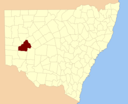
Livingstone County is one of the 141 Cadastral divisions of New South Wales. The Darling River is the western and north-western boundary, near Menindee.

Livingstone County was named in honour after the African missionary and explorer David Livingstone (1813-1873).[1]

Parishes within this county

A full list of parishes found within this county; their current LGA and mapping coordinates to the approximate centre of each location is as follows:

Parish LGA Coordinates
Albemarle Central Darling Shire 32°19′13″S 142°39′40″E / 32.32028°S 142.66111°E / -32.32028; 142.66111 (Albemarle)
Arlington Central Darling Shire 32°27′30″S 143°45′32″E / 32.45833°S 143.75889°E / -32.45833; 143.75889 (Arlington)
Ashbourne Central Darling Shire 32°19′46″S 143°23′35″E / 32.32944°S 143.39306°E / -32.32944; 143.39306 (Ashbourne)
Berangabah Central Darling Shire 32°29′45″S 143°31′58″E / 32.49583°S 143.53278°E / -32.49583; 143.53278 (Berangabah)
Billitong Central Darling Shire 32°08′26″S 143°10′52″E / 32.14056°S 143.18111°E / -32.14056; 143.18111 (Billitong)
Bindi Central Darling Shire 32°27′48″S 143°12′01″E / 32.46333°S 143.20028°E / -32.46333; 143.20028 (Bindi)
Blenalben Central Darling Shire 32°22′43″S 143°49′06″E / 32.37861°S 143.81833°E / -32.37861; 143.81833 (Blenalben)
Blenheim Central Darling Shire 32°21′22″S 142°31′28″E / 32.35611°S 142.52444°E / -32.35611; 142.52444 (Blenheim)
Boliva Central Darling Shire 32°38′00″S 142°51′31″E / 32.6333333°S 142.85861°E / -32.6333333; 142.85861 (Boliva)
Boolaboolka Central Darling Shire 32°36′04″S 143°12′44″E / 32.60111°S 143.21222°E / -32.60111; 143.21222 (Boolaboolka)
Boomery Central Darling Shire 32°16′03″S 143°13′47″E / 32.2675°S 143.22972°E / -32.2675; 143.22972 (Boomery)
Boonditti Central Darling Shire 32°21′29″S 142°56′52″E / 32.35806°S 142.94778°E / -32.35806; 142.94778 (Boonditti)
Boonoona Central Darling Shire 32°38′47″S 143°01′52″E / 32.64639°S 143.03111°E / -32.64639; 143.03111 (Boonoona)
Boothingalla Central Darling Shire 32°11′41″S 143°02′23″E / 32.19472°S 143.03972°E / -32.19472; 143.03972 (Boothingalla)
Brainerd Central Darling Shire 31°59′37″S 143°10′19″E / 31.99361°S 143.17194°E / -31.99361; 143.17194 (Brainerd)
Brunker Central Darling Shire 31°56′48″S 143°04′41″E / 31.94667°S 143.07806°E / -31.94667; 143.07806 (Brunker)
Burndoo Central Darling Shire 32°09′35″S 143°41′52″E / 32.15972°S 143.69778°E / -32.15972; 143.69778 (Burndoo)
Clifford Central Darling Shire 31°52′13″S 143°10′58″E / 31.87028°S 143.18278°E / -31.87028; 143.18278 (Clifford)
Connulpie Central Darling Shire 32°39′58″S 143°22′18″E / 32.66611°S 143.37167°E / -32.66611; 143.37167 (Connulpie)
Conolly Central Darling Shire 32°36′22″S 142°36′31″E / 32.60611°S 142.60861°E / -32.60611; 142.60861 (Conolly)
Coveney Central Darling Shire 32°04′06″S 143°19′15″E / 32.06833°S 143.32083°E / -32.06833; 143.32083 (Coveney)
Cowary Central Darling Shire unknown
Culpaulin Central Darling Shire unknown
Dromore Central Darling Shire 32°23′21″S 143°34′20″E / 32.38917°S 143.57222°E / -32.38917; 143.57222 (Cowary)
Gemini Central Darling Shire 32°24′40″S 142°40′21″E / 32.41111°S 142.6725°E / -32.41111; 142.6725 (Gemini)
Gordon Central Darling Shire 32°25′40″S 142°50′09″E / 32.42778°S 142.83583°E / -32.42778; 142.83583 (Gordon)
Haribel Central Darling Shire 32°00′24″S 143°20′00″E / 32.00667°S 143.3333333°E / -32.00667; 143.3333333 (Haribel)
Huco Central Darling Shire 32°35′03″S 143°02′22″E / 32.58417°S 143.03944°E / -32.58417; 143.03944 (Huco)
Hudson Central Darling Shire 32°17′53″S 143°44′48″E / 32.29806°S 143.74667°E / -32.29806; 143.74667 (Hudson)
Liddell Central Darling Shire 32°12′38″S 142°43′30″E / 32.21056°S 142.725°E / -32.21056; 142.725 (Liddell)
Makingah Central Darling Shire 32°32′52″S 142°37′02″E / 32.54778°S 142.61722°E / -32.54778; 142.61722 (Makingah)
Mandy Central Darling Shire 32°41′50″S 142°45′01″E / 32.69722°S 142.75028°E / -32.69722; 142.75028 (Mandy)
Marlborough Central Darling Shire 31°48′33″S 143°16′31″E / 31.80917°S 143.27528°E / -31.80917; 143.27528 (Marlborough)
Marle Central Darling Shire 32°02′18″S 143°32′31″E / 32.03833°S 143.54194°E / -32.03833; 143.54194 (Marle)
Minden Central Darling Shire 32°09′47″S 143°22′24″E / 32.16306°S 143.37333°E / -32.16306; 143.37333 (Minden)
Mourte Central Darling Shire 32°31′02″S 142°46′30″E / 32.51722°S 142.775°E / -32.51722; 142.775 (Mourte)
Mundy Central Darling Shire 32°17′01″S 142°51′56″E / 32.28361°S 142.86556°E / -32.28361; 142.86556 (Mundy)
Newcome Central Darling Shire 32°11′14″S 142°51′16″E / 32.18722°S 142.85444°E / -32.18722; 142.85444 (Newcome)
Pysant Central Darling Shire 32°18′14″S 143°03′13″E / 32.30389°S 143.05361°E / -32.30389; 143.05361 (Pysant)
Repton Central Darling Shire 32°01′13″S 143°01′40″E / 32.02028°S 143.02778°E / -32.02028; 143.02778 (Repton)
Sadlier Central Darling Shire 32°23′27″S 143°03′42″E / 32.39083°S 143.06167°E / -32.39083; 143.06167 (Sadlier)
Steel Central Darling Shire 32°25′11″S 142°30′49″E / 32.41972°S 142.51361°E / -32.41972; 142.51361 (Steel)
Surbiton Central Darling Shire 32°08′45″S 142°53′14″E / 32.14583°S 142.88722°E / -32.14583; 142.88722 (Surbiton)
Talyawalka Central Darling Shire 32°28′57″S 142°27′25″E / 32.4825°S 142.45694°E / -32.4825; 142.45694 (Talyawalka)
Teryawinya Central Darling Shire 32°28′07″S 143°22′21″E / 32.46861°S 143.3725°E / -32.46861; 143.3725 (Teryawinya)
Tintinalogy Central Darling Shire 32°09′12″S 143°02′11″E / 32.15333°S 143.03639°E / -32.15333; 143.03639 (Tintinalogy)
Toorincaca Central Darling Shire 32°32′21″S 142°52′20″E / 32.53917°S 142.87222°E / -32.53917; 142.87222 (Toorincaca)
Undeathi Central Darling Shire 32°31′18″S 142°27′11″E / 32.52167°S 142.45306°E / -32.52167; 142.45306 (Undeathi)
Victoria Central Darling Shire 32°36′24″S 143°24′08″E / 32.60667°S 143.40222°E / -32.60667; 143.40222 (Victoria)
Wambah Central Darling Shire 32°24′38″S 142°25′22″E / 32.41056°S 142.42278°E / -32.41056; 142.42278 (Wambah)
Wanalla Central Darling Shire 32°15′34″S 143°33′20″E / 32.25944°S 143.55556°E / -32.25944; 143.55556 (Wanalla)
Weatherly Central Darling Shire 32°04′56″S 143°09′24″E / 32.08222°S 143.15667°E / -32.08222; 143.15667 (Weatherly)
Widgera Central Darling Shire 32°21′48″S 143°12′55″E / 32.36333°S 143.21528°E / -32.36333; 143.21528 (Widgera)
Yenda Central Darling Shire unknown

References

  1. ^ Geographical Names Board of NSW

Wikimedia Foundation. 2010.

Игры ⚽ Нужна курсовая?

Look at other dictionaries:

  • Young County, New South Wales — Infobox Australian cadastral name = Young state = New South Wales caption = Location in New South Wales near nw = Mootwingee near n = Yungnulgra near ne = Killara near e = Werunda near se = Livingstone near s = Livingstone near sw = Tandora near… …   Wikipedia

  • Tandora County, New South Wales — Infobox Australian cadastral name = Tandora state = New South Wales caption = Location in New South Wales near nw = Mootwingee near n = Mootwingee near ne = Young near e = Livingstone near se = Livingstone near s = Menindee near sw = Menindee… …   Wikipedia

  • Townsend County, New South Wales — Infobox Australian cadastral name = Townsend state = New South Wales caption = Location in New South Wales near nw = Waradgery near n = Waradgery near ne = Boyd near e = Urana near se = Denison near s = Moira (Vic) near sw = Cadell near w =… …   Wikipedia

  • Windeyer County, New South Wales — Infobox Australian cadastral name = Windeyer state = New South Wales caption = Location in New South Wales near nw = South Australia near n = Menindee near ne = Livingstone near e = Perry near se = Wentworth near s = Tara near sw = South… …   Wikipedia

  • Menindee County, New South Wales — Infobox Australian cadastral name = Menindee state = New South Wales caption = Location in New South Wales near nw = South Australia near n = Yancowinna near ne = Tandora near e = Livingstone near se = Perry near s = Windeyer near sw = South… …   Wikipedia

  • Perry County, New South Wales — Infobox Australian cadastral name = Perry state = New South Wales caption = Location in New South Wales near nw = Menindee near n = Livingstone near ne = Manara near e = Manara near se = Kilfera near s = Wentworth near sw = Wentworth near w =… …   Wikipedia

  • Werunda County, New South Wales — Infobox Australian cadastral name = Werunda state = New South Wales caption = Location in New South Wales near nw = Young near n = Killara near ne = Rankin near e = Rankin near se = Woore near s = Woore near sw = Livingstone near w = YoungWerunda …   Wikipedia

  • Woore County, New South Wales — Infobox Australian cadastral name = Woore state = New South Wales caption = Location in New South Wales near nw = Werunda near n = Rankin near ne = Booroondarra near e = Mossgiel near se = Mossgiel near s = Manara near sw = Livingstone near w =… …   Wikipedia

  • Manara County, New South Wales — Infobox Australian cadastral name = Manara state = New South Wales caption = Location in New South Wales near nw = Livingstone near n = Woore near ne = Mossgiel near e = Mossgiel near se = Waljeers near s = Kilfera near sw = Wentworth near w =… …   Wikipedia

  • Mitchell County, New South Wales — Map of all coordinates from Google Map of all coordinates from Bing Export all coordinates as KML …   Wikipedia

Share the article and excerpts

Direct link
Do a right-click on the link above
and select “Copy Link”