Windeyer County

Windeyer County
Windeyer
New South Wales
Windeyer NSW.PNG
Location in New South Wales
Lands administrative divisions around Windeyer
South Australia Menindee Livingstone
South Australia Windeyer Perry
South Australia Tara Wentworth

Windeyer County is one of the 141 Cadastral divisions of New South Wales. It is located between the Darling River and the border with South Australia. The Silver City Highway runs through it. Coombah Roadhouse is located there.

Windeyer County was named in honour of the barrister and politician Richard Windeyer (1806-1847).[1]

Parishes within this county

A full list of parishes found within this county; their current LGA and mapping coordinates to the approximate centre of each location is as follows:

Parish LGA Coordinates
Abena Unincorporated 33°06′32″S 141°57′53″E / 33.10889°S 141.96472°E / -33.10889; 141.96472 (Abena)
Antita Unincorporated 32°49′37″S 141°31′19″E / 32.82694°S 141.52194°E / -32.82694; 141.52194 (Antita)
Badham Unincorporated 33°04′24″S 141°17′24″E / 33.07333°S 141.29°E / -33.07333; 141.29 (Badham)
Barlow Unincorporated 32°42′27″S 141°22′21″E / 32.7075°S 141.3725°E / -32.7075; 141.3725 (Barlow)
Barrawanna Wentworth Shire 33°17′36″S 142°07′56″E / 33.29333°S 142.13222°E / -33.29333; 142.13222 (Barrawanna)
Barry Unincorporated 32°58′30″S 141°06′12″E / 32.975°S 141.10333°E / -32.975; 141.10333 (Barry)
Bingalong Unincorporated 32°46′46″S 142°11′58″E / 32.77944°S 142.19944°E / -32.77944; 142.19944 (Bingalong)
Bingerry Wentworth Shire 33°17′40″S 141°58′54″E / 33.29444°S 141.98167°E / -33.29444; 141.98167 (Bingerry)
Bluebush Unincorporated 32°49′31″S 141°05′23″E / 32.82528°S 141.08972°E / -32.82528; 141.08972 (Bluebush)
Boree Wentworth Shire 33°06′33″S 141°28′17″E / 33.10917°S 141.47139°E / -33.10917; 141.47139 (Boree)
Buckalow Unincorporated 32°57′40″S 141°26′57″E / 32.96111°S 141.44917°E / -32.96111; 141.44917 (Buckalow)
Coombah Unincorporated 32°53′24″S 141°37′58″E / 32.89°S 141.63278°E / -32.89; 141.63278 (Coombah)
Cuthero Unincorporated 33°03′21″S 142°12′23″E / 33.05583°S 142.20639°E / -33.05583; 142.20639 (Cuthero)
Ellerslie Unincorporated 32°48′51″S 142°04′46″E / 32.81417°S 142.07944°E / -32.81417; 142.07944 (Ellerslie)
Erreman Wentworth Shire 33°27′09″S 142°15′32″E / 33.4525°S 142.25889°E / -33.4525; 142.25889 (Erreman)
Illawla Wentworth Shire 33°21′24″S 141°58′00″E / 33.35667°S 141.9666667°E / -33.35667; 141.9666667 (Illawla)
Kertne Wentworth Shire 33°26′23″S 142°06′02″E / 33.43972°S 142.10056°E / -33.43972; 142.10056 (Kertne)
Kilon Wentworth Shire 33°20′19″S 142°20′19″E / 33.33861°S 142.33861°E / -33.33861; 142.33861 (Kilon)
Kudgee Unincorporated 32°50′09″S 141°42′27″E / 32.83583°S 141.7075°E / -32.83583; 141.7075 (Kudgee)
Mallara Wentworth Shire 33°26′37″S 142°28′49″E / 33.44361°S 142.48028°E / -33.44361; 142.48028 (Mallara)
Meroo Unincorporated 33°02′05″S 141°38′15″E / 33.03472°S 141.6375°E / -33.03472; 141.6375 (Meroo)
Milang Unincorporated 32°58′14″S 141°32′05″E / 32.97056°S 141.53472°E / -32.97056; 141.53472 (Milang)
Mooley Unincorporated 32°54′23″S 142°17′28″E / 32.90639°S 142.29111°E / -32.90639; 142.29111 (Mooley)
Mulga Unincorporated 32°44′36″S 141°05′40″E / 32.74333°S 141.09444°E / -32.74333; 141.09444 (Mulga)
Mullojama Wentworth Shire 33°24′28″S 142°29′23″E / 33.40778°S 142.48972°E / -33.40778; 142.48972 (Mullojama)
Leichhardt Unincorporated 33°03′35″S 142°03′05″E / 33.05972°S 142.05139°E / -33.05972; 142.05139 (Leichhardt)
Nadbuck Unincorporated 32°58′14″S 141°48′47″E / 32.97056°S 141.81306°E / -32.97056; 141.81306 (Nadbuck)
Nalim Unincorporated 32°53′46″S 141°43′08″E / 32.89611°S 141.71889°E / -32.89611; 141.71889 (Nalim)
Ootoowa Wentworth Shire 33°25′47″S 141°54′42″E / 33.42972°S 141.91167°E / -33.42972; 141.91167 (Ootoowa)
Orara Wentworth Shire 33°25′38″S 142°22′07″E / 33.42722°S 142.36861°E / -33.42722; 142.36861 (Orara)
Palinor Wentworth Shire 33°17′57″S 141°50′16″E / 33.29917°S 141.83778°E / -33.29917; 141.83778 (Palinor)
Pearson Unincorporated 32°39′26″S 141°04′35″E / 32.65722°S 141.07639°E / -32.65722; 141.07639 (Pearson)
Polia Wentworth Shire 33°16′07″S 142°18′45″E / 33.26861°S 142.3125°E / -33.26861; 142.3125 (Polia)
Popilta Wentworth Shire 33°08′20″S 141°46′18″E / 33.13889°S 141.77167°E / -33.13889; 141.77167 (Popilta)
Popio Unincorporated 33°05′36″S 141°47′34″E / 33.09333°S 141.79278°E / -33.09333; 141.79278 (Popio)
Power Unincorporated 32°57′27″S 142°03′06″E / 32.9575°S 142.05167°E / -32.9575; 142.05167 (Power)
Ramleh Unincorporated 32°45′17″S 141°50′19″E / 32.75472°S 141.83861°E / -32.75472; 141.83861 (Ramleh)
Spinifex Unincorporated 32°51′13″S 141°17′53″E / 32.85361°S 141.29806°E / -32.85361; 141.29806 (Spinifex)
Urntah Wentworth Shire 33°12′02″S 142°05′48″E / 33.20056°S 142.09667°E / -33.20056; 142.09667 (Urntah)
Wallara Unincorporated 32°46′01″S 141°57′55″E / 32.76694°S 141.96528°E / -32.76694; 141.96528 (Wallara)
Wanneba Unincorporated 32°43′17″S 141°42′25″E / 32.72139°S 141.70694°E / -32.72139; 141.70694 (Wanneba)
Wannella Unincorporated 32°55′07″S 141°56′27″E / 32.91861°S 141.94083°E / -32.91861; 141.94083 (Wannella)
Whurlie Unincorporated 32°57′18″S 142°09′54″E / 32.955°S 142.165°E / -32.955; 142.165 (Whurlie)
Willotia Unincorporated 32°51′41″S 142°18′26″E / 32.86139°S 142.30722°E / -32.86139; 142.30722 (Willotia)
Yaltolka Unincorporated 33°00′25″S 142°17′13″E / 33.00694°S 142.28694°E / -33.00694; 142.28694 (Yaltolka)
Yarlalla Wentworth Shire 33°09′29″S 141°56′05″E / 33.15806°S 141.93472°E / -33.15806; 141.93472 (Yarlalla)
Yartla Wentworth Shire 33°09′38″S 142°11′21″E / 33.16056°S 142.18917°E / -33.16056; 142.18917 (Yartla)

References

  1. ^ Geographical Names Board of NSW

Wikimedia Foundation. 2010.

Игры ⚽ Поможем написать курсовую

Look at other dictionaries:

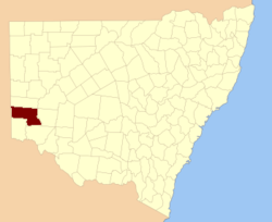
  • Windeyer County, New South Wales — Infobox Australian cadastral name = Windeyer state = New South Wales caption = Location in New South Wales near nw = South Australia near n = Menindee near ne = Livingstone near e = Perry near se = Wentworth near s = Tara near sw = South… …   Wikipedia

  • WINDEYER, Richard (1806-1847) — advocate and politician was the son of Charles Windeyer (1780 1855), first recognized reporter in the house of lords. The elder Windeyer came to Sydney in 1828, intending to go on the land, and obtained a grant of 2560 acres. He, however,… …   Dictionary of Australian Biography

  • Richard Windeyer — (10 August 1806 – 2 December 1847) was a barrister and Australian politician.BackgroundWindeyer was the son of Charles Windeyer (1780 1855), first recognised reporter in the House of Lords. The elder Windeyer went to Sydney in 1828, intending to… …   Wikipedia

  • Tara County, New South Wales — Infobox Australian cadastral name = Tara state = New South Wales caption = Location in New South Wales near nw = Hamley (SA) near n = Windeyer near ne = Windeyer near e = Wentworth near se = Karkarooc (Vic) near s = Millewa (Vic) near sw = Alfred …   Wikipedia

  • Tara County — Map of all coordinates from Google Map of all coordinates from Bing Export all coordinates as KML …   Wikipedia

  • Wentworth County — For the former county in Canada, see Wentworth County, Ontario. Map of all coordinates from Google Map of all coordinates from Bing Export all coordinates as KML …   Wikipedia

  • Livingstone County, New South Wales — Map of all coordinates from Google Map of all coordinates from Bing Export all coordinates as KML …   Wikipedia

  • Perry County, New South Wales — Infobox Australian cadastral name = Perry state = New South Wales caption = Location in New South Wales near nw = Menindee near n = Livingstone near ne = Manara near e = Manara near se = Kilfera near s = Wentworth near sw = Wentworth near w =… …   Wikipedia

  • Wentworth County, New South Wales — Infobox Australian cadastral name = Wentworth state = New South Wales caption = Location in New South Wales near nw = Windeyer near n = Perry near ne = Manara near e = Taila near se = Taila near s = Karkarooc (Vic) near sw = Millewa (Vic) near w …   Wikipedia

  • Menindee County, New South Wales — Infobox Australian cadastral name = Menindee state = New South Wales caption = Location in New South Wales near nw = South Australia near n = Yancowinna near ne = Tandora near e = Livingstone near se = Perry near s = Windeyer near sw = South… …   Wikipedia

Share the article and excerpts

Direct link
Do a right-click on the link above
and select “Copy Link”