- Yancowinna County
-
Yancowinna
New South Wales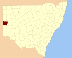
Location in New South WalesLands administrative divisions around Yancowinna South Australia Farnell Mootwingee South Australia Yancowinna Tandora South Australia Menindee Tandora 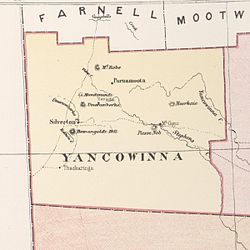 Yancowinna, shown in a map from 1886
Yancowinna County is one of the 141 Cadastral divisions of New South Wales. It contains the city of Broken Hill and village of Silverton.
Some New South Wales industrial relations laws have excluded the county of Yancowinna.[1] The county is also the only part of New South Wales which is in the same timezone as South Australia (+9.5 rather than +10).[2]
The name Yancowinna is believed to be derived from a local Aboriginal word and is also the name of the location within the county of Yancowinna Glen.[3]
Parishes within this county
A full list of parishes found within this county; their current LGA and mapping coordinates to the approximate centre of each location is as follows:
References
- ^ "NSW Office of Industrial Relations: Awards Online". www.industrialrelations.nsw.gov.au. http://www.industrialrelations.nsw.gov.au/awards/pathways/results.jsp?award_code=702&show=AID. Retrieved 2008-03-22.[dead link]
- ^ "New South Wales". wwp.greenwichmeantime.com. http://wwp.greenwichmeantime.com/time-zone/australia/new-south-wales/. Retrieved 2008-03-22.
- ^ "Extract - Geographical Names Board". www.gnb.nsw.gov.au. http://www.gnb.nsw.gov.au/name_search/extract?id=KWQloesyIt. Retrieved 2008-03-22.
Categories:- Counties of New South Wales


Wikimedia Foundation. 2010.