Farnell County

Farnell County
Farnell
New South Wales
Farnell NSW.PNG
Location in New South Wales
Lands administrative divisions around Farnell
South Australia Evelyn Mootwingee
South Australia Farnell Mootwingee
South Australia Yancowinna Mootwingee

Farnell County is one of the 141 Cadastral divisions of New South Wales.

Farnell County was named in honour of the Premier of New South Wales James Squire Farnell (1825-1888).[1]

Parishes within this county

A full list of parishes found within this county; their current LGA and mapping coordinates to the approximate centre of each location is as follows:

Parish LGA Coordinates
Alberta Unincorporated 31°23′10″S 141°23′54″E / 31.38611°S 141.39833°E / -31.38611; 141.39833 (Alberta)
Avenel Unincorporated 30°39′16″S 141°04′47″E / 30.65444°S 141.07972°E / -30.65444; 141.07972 (Avenel)
Badjerrigarn Unincorporated 31°12′35″S 141°29′25″E / 31.20972°S 141.49028°E / -31.20972; 141.49028 (Badjerrigarn)
Bligh Unincorporated 31°14′39″S 141°30′09″E / 31.24417°S 141.5025°E / -31.24417; 141.5025 (Bligh)
Boco Unincorporated 31°00′51″S 141°12′49″E / 31.01417°S 141.21361°E / -31.01417; 141.21361 (Boco)
Border Unincorporated 30°30′40″S 141°04′47″E / 30.51111°S 141.07972°E / -30.51111; 141.07972 (Border)
Brunker Unincorporated 30°57′16″S 141°04′46″E / 30.95444°S 141.07944°E / -30.95444; 141.07944 (Brunker)
Burgess Unincorporated 30°35′06″S 141°15′32″E / 30.585°S 141.25889°E / -30.585; 141.25889 (Burgess)
Byjerkerno Unincorporated 31°25′12″S 141°34′44″E / 31.42°S 141.57889°E / -31.42; 141.57889 (Byjerkerno)
Campbell Unincorporated 31°28′22″S 141°05′31″E / 31.47278°S 141.09194°E / -31.47278; 141.09194 (Campbell)
Chamberlain Unincorporated 31°09′52″S 141°13′56″E / 31.16444°S 141.23222°E / -31.16444; 141.23222 (Chamberlain)
Cook Unincorporated 31°09′58″S 141°21′43″E / 31.16611°S 141.36194°E / -31.16611; 141.36194 (Cook)
Coonbaralba Unincorporated 31°31′14″S 141°33′20″E / 31.52056°S 141.55556°E / -31.52056; 141.55556 (Coonbaralba)
Corona Unincorporated 31°17′26″S 141°23′59″E / 31.29056°S 141.39972°E / -31.29056; 141.39972 (Corona)
Cultee Unincorporated 30°56′07″S 141°24′37″E / 30.93528°S 141.41028°E / -30.93528; 141.41028 (Cultee)
Dering Unincorporated 31°27′43″S 141°35′53″E / 31.46194°S 141.59806°E / -31.46194; 141.59806 (Dering)
Floods Creek Unincorporated 30°51′09″S 141°38′54″E / 30.8525°S 141.64833°E / -30.8525; 141.64833 (Floods Creek)
Fowlers Gap Unincorporated 31°00′58″S 141°36′01″E / 31.01611°S 141.60028°E / -31.01611; 141.60028 (Fowlers Gap)
Giles Unincorporated 30°59′20″S 141°42′07″E / 30.98889°S 141.70194°E / -30.98889; 141.70194 (Giles)
Glenmore Unincorporated 31°09′43″S 141°04′49″E / 31.16194°S 141.08028°E / -31.16194; 141.08028 (Glenmore)
Gould Unincorporated 30°37′04″S 141°28′01″E / 30.61778°S 141.46694°E / -30.61778; 141.46694 (Gould)
Harris Unincorporated 31°13′48″S 141°14′41″E / 31.23°S 141.24472°E / -31.23; 141.24472 (Harris)
Kantappa Unincorporated 31°20′13″S 141°14′09″E / 31.33694°S 141.23583°E / -31.33694; 141.23583 (Kantappa)
Mulcatcha Unincorporated 31°27′34″S 141°14′27″E / 31.45944°S 141.24083°E / -31.45944; 141.24083 (Mulcatcha)
Patterson Unincorporated 31°03′05″S 141°20′06″E / 31.05139°S 141.335°E / -31.05139; 141.335 (Patterson)
Stanley Unincorporated 30°47′49″S 141°04′46″E / 30.79694°S 141.07944°E / -30.79694; 141.07944 (Stanley)
Sturt Unincorporated 31°05′48″S 141°28′10″E / 31.09667°S 141.46944°E / -31.09667; 141.46944 (Sturt)
Table Top Unincorporated 30°41′31″S 141°37′18″E / 30.69194°S 141.62167°E / -30.69194; 141.62167 (Table Top)
Tanyarto Unincorporated 31°08′39″S 141°36′52″E / 31.14417°S 141.61444°E / -31.14417; 141.61444 (Tanyarto)
Teilta Unincorporated 30°52′05″S 141°14′37″E / 30.86806°S 141.24361°E / -30.86806; 141.24361 (Teilta)
Torrowangee Unincorporated 31°28′57″S 141°23′59″E / 31.4825°S 141.39972°E / -31.4825; 141.39972 (Torrowangee)
Wammerra Unincorporated 30°46′06″S 141°24′49″E / 30.76833°S 141.41361°E / -30.76833; 141.41361 (Wammerra)
Wonna Unincorporated 30°41′34″S 141°15′08″E / 30.69278°S 141.25222°E / -30.69278; 141.25222 (Wonna)
Yowahro Unincorporated 31°14′17″S 141°05′38″E / 31.23806°S 141.09389°E / -31.23806; 141.09389 (Yowahro)

References

  1. ^ Geographical Names Board of NSW

Wikimedia Foundation. 2010.

Игры ⚽ Нужно сделать НИР?

Look at other dictionaries:

  • Farnell County, New South Wales — Infobox Australian cadastral name = Farnell state = New South Wales caption = Location in New South Wales near nw = South Australia near n = Evelyn near ne = Mootwingee near e = Mootwingee near se = Mootwingee near s = Yancowinna near sw = South… …   Wikipedia

  • Farnell — is a surname, thought to originate from Fern Hill . It is most common to the English county of Yorkshire.It may refer to:* Robert Farnell (1967), Consultant Orthopaedic Hand and Wrist Surgeon, Leeds * Anthony Farnell (1978), English boxer. *… …   Wikipedia

  • Farnell —    FARNELL, a parish, in the county of Forfar, 4 miles (S. E.) from Brechin; containing 620 inhabitants. This place derives its name, of Gaelic origin, from its having been anciently the resort of swans. The parish is about three miles in length …   A Topographical dictionary of Scotland

  • Farnell — This long established and widely distributed surname is of Anglo Saxon origin, and may be either a topographical name from residence by a fern covered hill, deriving from the Olde English pre 7th Century fearn , fern (a collective noun), with… …   Surnames reference

  • Cowper County — Cowper New South Wales Location in New South Wales Lands administrative divisions around Cowper …   Wikipedia

  • Clive County, New South Wales — Map of all coordinates from Google Map of all coordinates from Bing Export all coordinates as KML …   Wikipedia

  • Hillsborough County Public Schools — SDHC Logo Hillsborough County Public Schools, Florida is a school district headquartered in Tampa, Florida. It is more commonly referred to as the School District of Hillsborough County, or SDHC. The SDHC serves all of Hillsborough County and is… …   Wikipedia

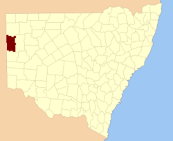
  • Yancowinna County, New South Wales — Infobox Australian cadastral name = Yancowinna state = New South Wales caption = Location in New South Wales near nw = South Australia near n = Farnell near ne = Mootwingee near e = Tandora near se = Tandora near s = Menindee near sw = South… …   Wikipedia

  • Yancowinna County — Map of all coordinates from Google Map of all coordinates from Bing Export all coordinates as KML …   Wikipedia

  • Evelyn County, New South Wales — Infobox Australian cadastral name = Evelyn state = New South Wales caption = Location in New South Wales near nw = South Australia near n = Poole near ne = Tongowoko near e = Yantara near se = Mootwingee near s = Farnell near sw = South Australia …   Wikipedia

Share the article and excerpts

Direct link
Do a right-click on the link above
and select “Copy Link”