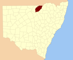
Finch County

Finch County
Finch
New South Wales
Finch NSW.PNG
Location in New South Wales
Lands administrative divisions around Finch
Queensland Queensland Queensland
Narran Finch Benarba
Clyde Leichardt Denham

Finch County is one of the 141 Cadastral divisions of New South Wales. It is bounded by the Narran River in the west, the Barwon River to the south and east, and the Queensland border to the north. It includes Lightning Ridge.

Finch County was named in honour of surveyor Heneage Finch.[1]

Parishes within this county

A full list of parishes found within this county; their current LGA and mapping coordinates to the approximate centre of each location is as follows:

Parish LGA Coordinates
Bagot Walgett Shire 29°05′46″S 148°39′44″E / 29.09611°S 148.66222°E / -29.09611; 148.66222 (Bagot)
Baloon Walgett Shire 29°00′55″S 148°36′21″E / 29.01528°S 148.60583°E / -29.01528; 148.60583 (Baloon)
Barnbah Walgett Shire 29°54′45″S 147°45′24″E / 29.9125°S 147.75667°E / -29.9125; 147.75667 (Barnbah)
Barrangeel Walgett Shire 29°27′16″S 148°03′55″E / 29.45444°S 148.06528°E / -29.45444; 148.06528 (Barrangeel)
Bibble Moree Plains Shire 29°07′28″S 148°50′55″E / 29.12444°S 148.84861°E / -29.12444; 148.84861 (Bibble)
Bimber Walgett Shire 29°49′43″S 147°57′07″E / 29.82861°S 147.95194°E / -29.82861; 147.95194 (Bimber)
Birben Walgett Shire 29°17′09″S 147°51′08″E / 29.28583°S 147.85222°E / -29.28583; 147.85222 (Birben)
Birrah Walgett Shire 29°13′26″S 148°02′04″E / 29.22389°S 148.03444°E / -29.22389; 148.03444 (Birrah)
Blackwood Walgett Shire 29°38′29″S 147°36′58″E / 29.64139°S 147.61611°E / -29.64139; 147.61611 (Blackwood)
Bloxsome Walgett Shire 29°28′12″S 148°09′35″E / 29.47°S 148.15972°E / -29.47; 148.15972 (Bloxsome)
Bogra Walgett Shire 29°54′29″S 147°52′09″E / 29.90806°S 147.86917°E / -29.90806; 147.86917 (Bogra)
Bon Bon Walgett Shire 29°53′36″S 148°00′58″E / 29.89333°S 148.01611°E / -29.89333; 148.01611 (Bon Bon)
Boorara Walgett Shire 29°01′30″S 148°29′08″E / 29.025°S 148.48556°E / -29.025; 148.48556 (Boorara)
Boorooma Walgett Shire 30°00′44″S 147°29′08″E / 30.01222°S 147.48556°E / -30.01222; 147.48556 (Boorooma)
Borah Walgett Shire 29°39′00″S 148°08′00″E / 29.65°S 148.1333333°E / -29.65; 148.1333333 (Borah)
Buddah Walgett Shire 29°48′14″S 147°34′45″E / 29.80389°S 147.57917°E / -29.80389; 147.57917 (Buddah)
Buggee Walgett Shire 29°33′08″S 147°59′26″E / 29.55222°S 147.99056°E / -29.55222; 147.99056 (Buggee)
Bukkulla Walgett Shire 29°24′02″S 148°25′06″E / 29.40056°S 148.41833°E / -29.40056; 148.41833 (Bukkulla)
Bumble Walgett Shire 29°07′43″S 148°10′56″E / 29.12861°S 148.18222°E / -29.12861; 148.18222 (Bumble)
Bundabarrina Walgett Shire 29°39′08″S 148°24′29″E / 29.65222°S 148.40806°E / -29.65222; 148.40806 (Bundabarrina)
Bundah Walgett Shire 29°36′14″S 148°08′30″E / 29.60389°S 148.14167°E / -29.60389; 148.14167 (Bundah)
Bunghill Walgett Shire 29°47′17″S 147°43′21″E / 29.78806°S 147.7225°E / -29.78806; 147.7225 (Bunghill)
Burbah Walgett Shire 29°01′08″S 148°17′25″E / 29.01889°S 148.29028°E / -29.01889; 148.29028 (Burbah)
Burrabebe Walgett Shire 29°23′02″S 147°54′30″E / 29.38389°S 147.90833°E / -29.38389; 147.90833 (Burrabebe)
Burran Burran Walgett Shire 29°11′25″S 148°42′14″E / 29.19028°S 148.70389°E / -29.19028; 148.70389 (Burran Burran)
Burrandown Walgett Shire 29°01′25″S 148°50′41″E / 29.02361°S 148.84472°E / -29.02361; 148.84472 (Burrandown)
Burrawandool Walgett Shire 29°07′09″S 148°27′50″E / 29.11917°S 148.46389°E / -29.11917; 148.46389 (Burrawandool)
Calmuldi Walgett Shire 29°44′46″S 148°20′58″E / 29.74611°S 148.34944°E / -29.74611; 148.34944 (Calmuldi)
Cambo Cambo Walgett Shire 29°05′41″S 148°33′23″E / 29.09472°S 148.55639°E / -29.09472; 148.55639 (Cambo Cambo)
Campbell Walgett Shire 29°39′13″S 148°13′32″E / 29.65361°S 148.22556°E / -29.65361; 148.22556 (Campbell)
Collarindabri Walgett Shire 29°32′03″S 148°35′13″E / 29.53417°S 148.58694°E / -29.53417; 148.58694 (Collarindabri)
Combadery Walgett Shire 30°00′02″S 147°58′29″E / 30.00056°S 147.97472°E / -30.00056; 147.97472 (Combadery)
Coocoran Walgett Shire 29°26′41″S 147°44′35″E / 29.44472°S 147.74306°E / -29.44472; 147.74306 (Coocoran)
Coogarah Walgett Shire 29°34′41″S 147°52′47″E / 29.57806°S 147.87972°E / -29.57806; 147.87972 (Coogarah)
Corona Walgett Shire 29°45′42″S 147°27′59″E / 29.76167°S 147.46639°E / -29.76167; 147.46639 (Corona)
Cowelba Walgett Shire 29°22′00″S 148°20′20″E / 29.3666667°S 148.33889°E / -29.3666667; 148.33889 (Cowelba)
Cumborah Walgett Shire 29°45′50″S 147°43′50″E / 29.76389°S 147.73056°E / -29.76389; 147.73056 (Cumborah)
Cunnianna Walgett Shire 29°33′17″S 148°18′46″E / 29.55472°S 148.31278°E / -29.55472; 148.31278 (Cunnianna)
Currall Walgett Shire 29°38′56″S 147°26′34″E / 29.64889°S 147.44278°E / -29.64889; 147.44278 (Currall)
Daraaba Walgett Shire 29°04′57″S 148°16′04″E / 29.0825°S 148.26778°E / -29.0825; 148.26778 (Daraaba)
Deripas Walgett Shire 29°31′29″S 148°03′40″E / 29.52472°S 148.06111°E / -29.52472; 148.06111 (Deripas)
Dungalear Walgett Shire 29°49′16″S 148°15′15″E / 29.82111°S 148.25417°E / -29.82111; 148.25417 (Dungalear)
Dungell Walgett Shire 29°21′43″S 148°05′46″E / 29.36194°S 148.09611°E / -29.36194; 148.09611 (Dungell)
Dunumbral Walgett Shire 29°30′54″S 148°13′47″E / 29.515°S 148.22972°E / -29.515; 148.22972 (Dunumbral)
Durabeba Walgett Shire 29°32′25″S 147°53′54″E / 29.54028°S 147.89833°E / -29.54028; 147.89833 (Durabeba)
Eales Walgett Shire 29°58′17″S 147°38′02″E / 29.97139°S 147.63389°E / -29.97139; 147.63389 (Eales)
Eckford Walgett Shire 29°18′23″S 148°39′04″E / 29.30639°S 148.65111°E / -29.30639; 148.65111 (Eckford)
Elphinstone Walgett Shire 29°12′51″S 147°53′53″E / 29.21417°S 147.89806°E / -29.21417; 147.89806 (Elphinstone)
Eulan Walgett Shire 29°20′37″S 147°58′09″E / 29.34361°S 147.96917°E / -29.34361; 147.96917 (Eulan)
Euminbah Walgett Shire 29°54′34″S 148°09′17″E / 29.90944°S 148.15472°E / -29.90944; 148.15472 (Euminbah)
Eurawin Walgett Shire 29°40′50″S 147°52′39″E / 29.68056°S 147.8775°E / -29.68056; 147.8775 (Eurawin)
Finch Walgett Shire 29°23′36″S 147°39′52″E / 29.39333°S 147.66444°E / -29.39333; 147.66444 (Finch)
Gamalally Walgett Shire 29°20′49″S 148°32′22″E / 29.34694°S 148.53944°E / -29.34694; 148.53944 (Gamalally)
Gingie Walgett Shire 29°58′10″S 148°03′24″E / 29.96944°S 148.05667°E / -29.96944; 148.05667 (Gingie)
Glatherindi Walgett Shire 29°36′30″S 148°23′16″E / 29.60833°S 148.38778°E / -29.60833; 148.38778 (Glatherindi)
Gooningeri Walgett Shire 29°22′51″S 148°15′31″E / 29.38083°S 148.25861°E / -29.38083; 148.25861 (Gooningeri)
Gooraway Walgett Shire 29°35′10″S 148°01′34″E / 29.58611°S 148.02611°E / -29.58611; 148.02611 (Gooraway)
Gordon Walgett Shire 29°44′20″S 148°03′59″E / 29.73889°S 148.06639°E / -29.73889; 148.06639 (Gordon)
Gorie Gorie Walgett Shire 29°52′32″S 147°45′33″E / 29.87556°S 147.75917°E / -29.87556; 147.75917 (Gorie Gorie)
Grawin Walgett Shire 29°31′11″S 147°40′04″E / 29.51972°S 147.66778°E / -29.51972; 147.66778 (Grawin)
Greaves Walgett Shire 29°02′30″S 148°05′59″E / 29.04167°S 148.09972°E / -29.04167; 148.09972 (Greaves)
Green Walgett Shire 29°29′56″S 148°30′36″E / 29.49889°S 148.51°E / -29.49889; 148.51 (Green)
Gummanaldi Walgett Shire 29°18′25″S 148°20′45″E / 29.30694°S 148.34583°E / -29.30694; 148.34583 (Gummanaldi)
Gundabloui Walgett Shire 29°12′26″S 148°34′39″E / 29.20722°S 148.5775°E / -29.20722; 148.5775 (Gundabloui)
Gurilly Walgett Shire 29°32′46″S 147°30′22″E / 29.54611°S 147.50611°E / -29.54611; 147.50611 (Gurilly)
Gurley Walgett Shire 29°32′03″S 147°48′25″E / 29.53417°S 147.80694°E / -29.53417; 147.80694 (Gurley)
Hungerford Walgett Shire 29°45′52″S 148°16′28″E / 29.76444°S 148.27444°E / -29.76444; 148.27444 (Hungerford)
Imbergee Walgett Shire unknown
Kee Kee Walgett Shire 29°46′44″S 147°57′15″E / 29.77889°S 147.95417°E / -29.77889; 147.95417 (Kee Kee)
Keilmoi Walgett Shire 29°02′00″S 148°11′33″E / 29.0333333°S 148.1925°E / -29.0333333; 148.1925 (Keilmoi)
Kennedy Walgett Shire 29°17′54″S 148°27′04″E / 29.29833°S 148.45111°E / -29.29833; 148.45111 (Kennedy)
Kigwigil Walgett Shire 29°40′55″S 147°37′32″E / 29.68194°S 147.62556°E / -29.68194; 147.62556 (Kigwigil)
Kurragong Walgett Shire 29°58′22″S 147°31′34″E / 29.97278°S 147.52611°E / -29.97278; 147.52611 (Kurragong)
Langloh Walgett Shire 29°22′14″S 147°49′21″E / 29.37056°S 147.8225°E / -29.37056; 147.8225 (Langloh)
Llanillo Walgett Shire 29°35′39″S 147°56′15″E / 29.59417°S 147.9375°E / -29.59417; 147.9375 (Llanillo)
Lolleep Walgett Shire 29°52′26″S 147°38′57″E / 29.87389°S 147.64917°E / -29.87389; 147.64917 (Lolleep)
Maggarie Walgett Shire 29°08′54″S 147°56′49″E / 29.14833°S 147.94694°E / -29.14833; 147.94694 (Maggarie)
Manning Walgett Shire 29°43′27″S 147°35′16″E / 29.72417°S 147.58778°E / -29.72417; 147.58778 (Manning)
Mebea Walgett Shire 29°24′27″S 147°54′11″E / 29.4075°S 147.90306°E / -29.4075; 147.90306 (Mebea)
Mein Walgett Shire 29°35′24″S 147°36′05″E / 29.59°S 147.60139°E / -29.59; 147.60139 (Mein)
Milrea Walgett Shire 30°03′00″S 147°37′16″E / 30.05°S 147.62111°E / -30.05; 147.62111 (Milrea)
Mogil Mogul Walgett Shire 29°23′39″S 148°38′05″E / 29.39417°S 148.63472°E / -29.39417; 148.63472 (Mogil Mogul)
Moongulla Walgett Shire 29°27′28″S 148°19′31″E / 29.45778°S 148.32528°E / -29.45778; 148.32528 (Moongulla)
Mooni Walgett Shire 29°02′37″S 148°43′32″E / 29.04361°S 148.72556°E / -29.04361; 148.72556 (Mooni)
Mooroo Walgett Shire 29°51′28″S 148°05′19″E / 29.85778°S 148.08861°E / -29.85778; 148.08861 (Mooroo)
Moramina Walgett Shire 29°52′40″S 147°54′27″E / 29.87778°S 147.9075°E / -29.87778; 147.9075 (Moramina)
Morendah Walgett Shire 29°33′34″S 147°42′22″E / 29.55944°S 147.70611°E / -29.55944; 147.70611 (Morendah)
Mullingowba Walgett Shire 29°12′17″S 148°19′45″E / 29.20472°S 148.32917°E / -29.20472; 148.32917 (Mullingowba)
Mundoo Walgett Shire 29°14′59″S 148°10′08″E / 29.24972°S 148.16889°E / -29.24972; 148.16889 (Mundoo)
Mureabun Walgett Shire 29°36′32″S 147°28′10″E / 29.60889°S 147.46944°E / -29.60889; 147.46944 (Mureabun)
Narran Walgett Shire 29°02′30″S 148°23′03″E / 29.04167°S 148.38417°E / -29.04167; 148.38417 (Narran)
Peelborough Walgett Shire 29°25′04″S 148°11′43″E / 29.41778°S 148.19528°E / -29.41778; 148.19528 (Peelborough)
Pine Walgett Shire 29°39′48″S 147°33′08″E / 29.66333°S 147.55222°E / -29.66333; 147.55222 (Pine)
Pinegobla Walgett Shire 29°15′58″S 148°15′39″E / 29.26611°S 148.26083°E / -29.26611; 148.26083 (Pinegobla)
Plumbolah Walgett Shire 29°48′01″S 147°50′08″E / 29.80028°S 147.83556°E / -29.80028; 147.83556 (Plumbolah)
Queega Walgett Shire 29°29′19″S 147°49′43″E / 29.48861°S 147.82861°E / -29.48861; 147.82861 (Queega)
Rose Walgett Shire 29°43′43″S 147°56′51″E / 29.72861°S 147.9475°E / -29.72861; 147.9475 (Rose)
Scott Walgett Shire 30°01′59″S 147°50′15″E / 30.03306°S 147.8375°E / -30.03306; 147.8375 (Scott)
Somerville Walgett Shire 29°36′59″S 148°13′31″E / 29.61639°S 148.22528°E / -29.61639; 148.22528 (Somerville)
Talawa Walgett Shire 29°12′16″S 148°10′43″E / 29.20444°S 148.17861°E / -29.20444; 148.17861 (Talawa)
Telinebone Walgett Shire 29°49′54″S 147°50′46″E / 29.83167°S 147.84611°E / -29.83167; 147.84611 (Telinebone)
Tomorrago Walgett Shire 29°22′33″S 148°01′28″E / 29.37583°S 148.02444°E / -29.37583; 148.02444 (Tomorrago)
Townday Walgett Shire 29°06′41″S 148°45′26″E / 29.11139°S 148.75722°E / -29.11139; 148.75722 (Townday)
Tutawa Walgett Shire 29°11′36″S 148°07′29″E / 29.19333°S 148.12472°E / -29.19333; 148.12472 (Tutawa)
Ulah Walgett Shire 30°01′11″S 147°43′42″E / 30.01972°S 147.72833°E / -30.01972; 147.72833 (Ulah)
Urandool Walgett Shire 29°41′21″S 148°02′52″E / 29.68917°S 148.04778°E / -29.68917; 148.04778 (Urandool)
Wallah Walgett Shire 29°36′18″S 148°18′18″E / 29.605°S 148.305°E / -29.605; 148.305 (Wallah)
Wallangulla Walgett Shire 29°27′47″S 147°58′33″E / 29.46306°S 147.97583°E / -29.46306; 147.97583 (Wallangulla)
Wammell Walgett Shire 29°25′53″S 147°49′00″E / 29.43139°S 147.8166667°E / -29.43139; 147.8166667 (Wammell)
Waugh Walgett Shire 29°49′19″S 148°05′44″E / 29.82194°S 148.09556°E / -29.82194; 148.09556 (Waugh)
Wee Warra Walgett Shire 29°42′06″S 147°44′25″E / 29.70167°S 147.74028°E / -29.70167; 147.74028 (Wee Warra)
Werribilla Walgett Shire 29°27′21″S 148°38′17″E / 29.45583°S 148.63806°E / -29.45583; 148.63806 (Werribilla)
Wilby Wilby Walgett Shire 29°26′18″S 147°36′04″E / 29.43833°S 147.60111°E / -29.43833; 147.60111 (Wilby Wilby)
Wilga Walgett Shire 29°43′14″S 148°10′55″E / 29.72056°S 148.18194°E / -29.72056; 148.18194 (Wilga)
Wilkie Walgett Shire 29°52′22″S 147°32′26″E / 29.87278°S 147.54056°E / -29.87278; 147.54056 (Wilkie)
Wooburrabebe Walgett Shire 29°16′29″S 148°00′06″E / 29.27472°S 148.00167°E / -29.27472; 148.00167 (Wooburrabebe)
Yarraman Walgett Shire 29°29′33″S 148°23′41″E / 29.4925°S 148.39472°E / -29.4925; 148.39472 (Yarraman)
Yeranbah Walgett Shire 29°04′53″S 148°06′56″E / 29.08139°S 148.11556°E / -29.08139; 148.11556 (Yeranbah)
Yerangle Walgett Shire 29°47′42″S 148°11′30″E / 29.795°S 148.19167°E / -29.795; 148.19167 (Yerangle)
Yourblah Walgett Shire 29°19′09″S 148°06′20″E / 29.31917°S 148.10556°E / -29.31917; 148.10556 (Yourblah)

References

  1. ^ Geographical Names Board of NSW

Wikimedia Foundation. 2010.

Игры ⚽ Нужно сделать НИР?

Look at other dictionaries:

  • Finch County, New South Wales — Infobox Australian cadastral name = Finch state = New South Wales caption = Location in New South Wales near nw = Queensland near n = Queensland near ne = Queensland near e = Benarba near se = Denham near s = Leichardt near sw = Clyde near w =… …   Wikipedia

  • Finch Farm — is the training ground for Everton F.C., in the Knowsley suburb of Halewood. The football academy is also on site.The School of Science is the nickname given to the complex by some supporters, referring to a long standing nickname for the club.… …   Wikipedia

  • County of Belmore — Belmore Queensland Location within Queensland Lands administrative divisions around Belmore …   Wikipedia

  • Clement Finch — Finch, Clement Alfred Born Broadalbin Town, New York Died La Jolla, San Diego, California Ethnicity Caucasian Citizenship US Citizen Education …   Wikipedia

  • Cleo Finch — Michael Michele as Cleo Finch First appearance September 30, 1999 (Season 6, Leave It to Weaver ) Last appearance …   Wikipedia

  • House Finch — Taxobox name = House Finch status = LC | status system = IUCN3.1 status ref = [IUCN2006|assessors=BirdLife International|year=2004|id=53468|title=Carpodacus mexicanus|downloaded=12 May 2006] image width = 250px regnum = Animalia phylum = Chordata …   Wikipedia

  • National Register of Historic Places listings in Spokane County, Washington — List of entries on the National Register of Historic Places in Spokane County, Washington See also National Register of Historic Places listings in Washington This National Park Service list is complete through NPS recent listings posted November …   Wikipedia

  • Atticus Finch — is a fictional character in Harper Lee s Pulitzer Prize winning novel To Kill a Mockingbird . Atticus is a lawyer and resident of Maycomb County, Alabama, and the father of Jeremy Atticus Jem Finch and Jean Louise Scout Finch. Atticus is one of… …   Wikipedia

  • National Register of Historic Places listings in Ramsey County, Minnesota — Ramsey County This is a complete list of National Register of Historic Places listings in Ramsey County, Minnesota. There are 111 properties in the county listed on the National Register of Historic Places including three National Historic… …   Wikipedia

  • National Register of Historic Places listings in Kootenai County, Idaho — Location of Kootenai County in Idaho This is a list of the National Register of Historic Places listings in Kootenai County, Idaho. This is intended to be a complete list of the properties and districts on the National Register of Historic Places …   Wikipedia

Share the article and excerpts

Direct link
Do a right-click on the link above
and select “Copy Link”