County of Belmore

County of Belmore
Belmore
Queensland
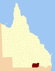
Belmore-county-queensland.png
Location within Queensland
Lands administrative divisions around Belmore
Tomoo Maranoa,
Elgin
Pring
Mungallala,
Nebine
Belmore Carnarvon
Narran (NSW) Finch (NSW) Benarba (NSW)

The County of Belmore is a county in Queensland, Australia, located west of the Darling Downs in the Shire of Balonne. Like all counties in Queensland, it is a non-functional administrative unit, that is used mainly for the purpose of registering land titles.[1] It was officially named and bounded by the Governor in Council on 7 March 1901 under the Land Act 1897.[2]

Parishes

Belmore is divided into parishes, listed as follows:

Parish LGA Coordinates
Alton Balonne 28°06′S 149°15′E / 28.1°S 149.25°E / -28.1; 149.25 (Alton Parish)
Bogiria Balonne 28°54′S 147°47′E / 28.9°S 147.783°E / -28.9; 147.783 (Bogiria Parish)
Bollon Balonne 28°00′S 147°26′E / 28°S 147.433°E / -28; 147.433 (Bollon Parish)
Bookalong Balonne 28°37′S 148°22′E / 28.617°S 148.367°E / -28.617; 148.367 (Bookalong Parish)
Booligar Balonne 28°42′S 148°15′E / 28.7°S 148.25°E / -28.7; 148.25 (Booligar Parish)
Bullamon Balonne 28°39′S 148°52′E / 28.65°S 148.867°E / -28.65; 148.867 (Bullamon Parish)
Burgorah Balonne 27°59′S 148°44′E / 27.983°S 148.733°E / -27.983; 148.733 (Burgorah Parish)
Collyben Balonne 28°52′S 148°59′E / 28.867°S 148.983°E / -28.867; 148.983 (Collyben Parish)
Currawildi Balonne 28°40′S 148°07′E / 28.667°S 148.117°E / -28.667; 148.117 (Currawildi Parish)
Dareel Balonne 28°49′S 148°49′E / 28.817°S 148.817°E / -28.817; 148.817 (Dareel Parish)
Doondi Balonne 28°22′S 148°25′E / 28.367°S 148.417°E / -28.367; 148.417 (Doondi Parish)
Euraba Balonne 28°47′S 148°00′E / 28.783°S 148°E / -28.783; 148 (Euraba Parish)
Gerar Balonne 28°31′S 148°52′E / 28.517°S 148.867°E / -28.517; 148.867 (Gerar Parish)
Goonaro Balonne 28°55′S 147°59′E / 28.917°S 147.983°E / -28.917; 147.983 (Goonaro Parish)
Gurardera Goondiwindi 28°25′S 149°15′E / 28.417°S 149.25°E / -28.417; 149.25 (Gurardera Parish)
Karee Balonne 28°20′S 148°33′E / 28.333°S 148.55°E / -28.333; 148.55 (Karee Parish)
Mugan Goondiwindi 28°45′S 149°04′E / 28.75°S 149.067°E / -28.75; 149.067 (Mugan Parish)
Mungindi Balonne 28°55′S 148°52′E / 28.917°S 148.867°E / -28.917; 148.867 (Mungindi Parish)
Nindigully Balonne 28°22′S 148°52′E / 28.367°S 148.867°E / -28.367; 148.867 (Nindigully Parish)
St George Balonne 28°05′S 148°40′E / 28.083°S 148.667°E / -28.083; 148.667 (St George Parish)
Wagaily Balonne 27°59′S 148°33′E / 27.983°S 148.55°E / -27.983; 148.55 (Wagaily Parish)
Wandibingie Goondiwindi 28°34′S 149°07′E / 28.567°S 149.117°E / -28.567; 149.117 (Wandibingie Parish)
Weengallon Goondiwindi 28°22′S 149°02′E / 28.367°S 149.033°E / -28.367; 149.033 (Weengallon Parish)
Weeyan Balonne 27°44′S 148°49′E / 27.733°S 148.817°E / -27.733; 148.817 (Weeyan Parish)

References

  1. ^ Maranoa District, County of Belmore Maps - R1 Series at Queensland Archives.
  2. ^ Department of Environment and Resource Management. "Place name details — Belmore". http://www.derm.qld.gov.au/property/placenames/details.php?id=2237. Retrieved 10 June 2011. 

Coordinates: 28°02′S 148°35′E / 28.033°S 148.583°E / -28.033; 148.583


Wikimedia Foundation. 2010.

Игры ⚽ Нужна курсовая?

Look at other dictionaries:

  • County Fermanagh — Contae Fhear Manach Coontie Fermanagh Coat of arms …   Wikipedia

  • Belmore Mountain — Infobox Mountain Name = Belmore Mountain Photo = Belmore Mountain.jpg Caption = Elevation = 398 m Location = Northern Ireland Range = Prominence = 322 m Coordinates = Topographic Type = Age = Last eruption = First ascent = Easiest route = Grid… …   Wikipedia

  • Belmore, Ohio — Infobox Settlement official name = Belmore, Ohio settlement type = Village nickname = motto = imagesize = image caption = image mapsize = 250x200px map caption = Location of Belmore, Ohio mapsize1 = map caption1 = subdivision type = Country… …   Wikipedia

  • Putnam County (Ohio) — Putnam County Courthouse in Ottawa, gelistet im NRHP mit der Nr. 74001608[1] Verwaltung …   Deutsch Wikipedia

  • Somerset Lowry-Corry, 4th Earl Belmore — Somerset Richard Lowry Corry, 4th Earl Belmore GCMG PC (9 April 1835 ndash;6 April 1913), known as Viscount Corry from 1841 to 1845, was an Irish nobleman and Conservative politician.LifeBelmore was born in Bruton Street, London, the eldest son… …   Wikipedia

  • Earl Belmore — is a title in the Peerage of Ireland created in 1797 for Armar Lowry Corry, 1st Viscount Belmore, who had previously represented County Tyrone in the Irish House of Commons. He had already been created Baron Belmore, of Castle Coole in County… …   Wikipedia

  • Armar Lowry-Corry, 1st Earl Belmore — (April 7, 1740 February 2, 1802) was an Irish nobleman and politician.He was High Sheriff of County Tyrone from 1769 and of County Fermanagh from 1779. He was also Member of Parliament for County Tyrone in the Irish House of Commons from 1769 to… …   Wikipedia

  • Armar Lowry-Corry, 5th Earl Belmore — (5 May 1870 12 February 1948) was an Irish nobleman and the eldest son of Somerset Lowry Corry, 4th Earl Belmore.He was born in Government House, Sydney in Australia during his father s term as Governor of New South Wales, baptised in Sydney… …   Wikipedia

  • Earl Belmore — Castle Coole Earl Belmore ist ein erblicher Adelstitel in der Peerage of Ireland, der von der Familie Lowry Corry geführt wird. Frühere Familiensitz war Castle Coole bei Enniskillen im County Fermanagh. Verleihung Der Titel wurde 1797 für Armar… …   Deutsch Wikipedia

  • Armar Lowry-Corry, 3. Earl Belmore — (* 23. Dezember 1801 in Dublin; † 17. Dezember 1845 in County Fermanagh) war ein britischer Politiker irischer Herkunft. Von 1802 bis 1841 war er unter seinem damaligen Höflichkeitstitel Viscount Corry bekannt. Armar Lowry Corry wurde Dezember… …   Deutsch Wikipedia
Share the article and excerpts

Direct link
Do a right-click on the link above
and select “Copy Link”