- Menindee Lakes
-
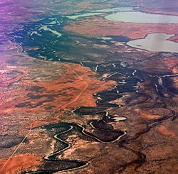 Aerial view of the Darling River and some of the Menindee Lakes
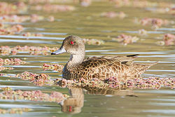 The lakes are important for Grey Teals
The Menindee Lakes comprise a system of historically ephemeral, freshwater lakes fed by the Darling River when in flood. They lie in the far west of New South Wales, Australia, near the town of Menindee 100 km south-east of the mining city of Broken Hill. Some of the lakes have been incorporated in an artificially regulated overflow system providing both for flood mitigation and as storage for domestic use, livestock and irrigation downstream. The lakes are also important for waterbirds.
Contents
Description
The lakes range in size from 103 ha to 15,900 ha. The largest are Lakes Menindee, Wetherell, Pamamaroo and Cawndilla. These four, with Tandure, Bijijie and Balaka, are part of the Menindee Lakes Water Storage Scheme, with Cawndilla and Menindee also within the Kinchega National Park. Lakes Nettlegoe, Kangaroo, Stir Tank, New and Malta are unregulated. Lake Tandou is managed as irrigated cropland and is no longer subject to flooding. The lakes lie in the semi-arid zone on grey clay and duplex soils, and siliceous and calcareous sands. The shallow margins of the overflow lakes are studded with dead Black Box trees while the shores are dominated by Bluerod and Sandhill Canegrass.[1]
Birds
Some 423 km² of the lakes and their surrounds, with the exception of Lake Tandou, have been identified by BirdLife International as an Important Bird Area (IBA) because it has supported up to 222,000 waterbirds, including over 1% of the world populations of Freckled Ducks, Grey Teals, Pink-eared Ducks, Red-necked Avocets, Sharp-tailed Sandpipers and Red-capped Plovers.[2] Other waterbirds sometimes using the lakes in large numbers are Australasian Shovelers, Australian Shelducks, Pied Cormorants, Yellow-billed Spoonbills, Eurasian Coots and White-headed Stilts. Other species recorded in the IBA include Australian Bustard, Black and Pied Honeyeaters, Chirruping Wedgebill and Grey Falcon.[1]
See also
- List of lakes of Australia
References
- ^ a b BirdLife International. (2011). Important Bird Areas factsheet: Menindee Lakes. Downloaded from http://www.birdlife.org on 15 August 2011.
- ^ "IBA: Menindee Lakes". Birdata. Birds Australia. http://www.birdata.com.au/iba.vm. Retrieved 2011-08-15.
Coordinates: 32°20′59″S 142°22′08″E / 32.34972°S 142.36889°E
Categories:- Important Bird Areas of Australia
- Lakes of New South Wales
- Darling River


Wikimedia Foundation. 2010.