Rous County

Rous County
Rous
New South Wales
Rous NSW.PNG
Location in New South Wales
Lands administrative divisions around Rous
Merivale (Qld) Ward (Qld) Pacific Ocean
Buller Rous Pacific Ocean
Drake Richmond Pacific Ocean

Rous County is one of the 141 Cadastral divisions of New South Wales. It is located at the north-east tip of the state. It is bordered on the north by the border with Queensland and on the south by the Richmond River. It contains Lismore, Byron Bay and Murwillumbah.

Rous County was named in honour of Admiral Henry John Rous (1795-1877).[1]

Parishes within this county

A full list of parishes found within this county; their current LGA and mapping coordinates to the approximate centre of each location is as follows:

Parish LGA Coordinates
Babyil Kyogle Shire 28°3754S 152°4504E / 28.63167°S 152.75111°E / -28.63167; 152.75111 (Babyil Parish)
Ballina Ballina Shire 28°4954S 153°3304E / 28.83167°S 153.55111°E / -28.83167; 153.55111 (Ballina Parish)
Berwick Tweed Shire 28°1354S 153°2504E / 28.23167°S 153.41778°E / -28.23167; 153.41778 (Berwick Parish)
Bexhill City of Lismore 28°4554S 153°2204E / 28.765°S 153.36778°E / -28.765; 153.36778 (Bexhill Parish)
Billinudgel Tweed Shire 28°3054S 153°3004E / 28.515°S 153.50111°E / -28.515; 153.50111 (Billinudgel Parish)
Bingal Ballina Shire 28°5654S 153°2804E / 28.94833°S 153.46778°E / -28.94833; 153.46778 (Bingal Parish)
Blakebrook City of Lismore 28°4554S 153°1604E / 28.765°S 153.26778°E / -28.765; 153.26778 (Blakebrook Parish)
Boorabee City of Lismore 28°3954S 153°0504E / 28.665°S 153.08444°E / -28.665; 153.08444 (Boorabee Parish)
Broadwater City of Lismore 29°0054S 153°2404E / 29.015°S 153.40111°E / -29.015; 153.40111 (Broadwater Parish)
Brunswick Byron Shire 28°3554S 153°3104E / 28.59833°S 153.51778°E / -28.59833; 153.51778 (Brunswick Parish)
Bungabbee City of Lismore 28°4354S 153°0804E / 28.73167°S 153.13444°E / -28.73167; 153.13444 (Bungabbee Parish)
Burrell Kyogle Shire 28°2354S 153°1504E / 28.39833°S 153.25111°E / -28.39833; 153.25111 (Burrell Parish)
Byron Byron Shire 28°3954S 153°3204E / 28.665°S 153.53444°E / -28.665; 153.53444 (Byron Parish)
Chillingham Kyogle Shire 28°1654S 153°1304E / 28.28167°S 153.21778°E / -28.28167; 153.21778 (Chillingham Parish)
Clunes City of Lismore 28°4054S 153°2504E / 28.68167°S 153.41778°E / -28.68167; 153.41778 (Clunes Parish)
Condong Tweed Shire 28°1954S 153°2704E / 28.33167°S 153.45111°E / -28.33167; 153.45111 (Condong Parish)
Coraki City of Lismore 29°0054S 153°1904E / 29.015°S 153.31778°E / -29.015; 153.31778 (Coraki Parish)
Cougal Kyogle Shire 28°2254S 152°5704E / 28.38167°S 152.95111°E / -28.38167; 152.95111 (Cougal Parish)
Cudgen Tweed Shire 28°1654S 153°3304E / 28.28167°S 153.55111°E / -28.28167; 153.55111 (Cudgen Parish)
Dunbible Tweed Shire 28°2254S 153°2304E / 28.38167°S 153.38444°E / -28.38167; 153.38444 (Dunbible Parish)
Dunoon City of Lismore 28°3954S 153°1904E / 28.665°S 153.31778°E / -28.665; 153.31778 (Dunoon Parish)
Dyraaba Kyogle Shire 28°4754S 152°4704E / 28.79833°S 152.78444°E / -28.79833; 152.78444 (Dyraaba Parish)
East Gundurimba City of Lismore 28°5154S 153°1804E / 28.865°S 153.30111°E / -28.865; 153.30111 (East Gundurimba Parish)
Ettrick Kyogle Shire 28°3454S 152°5204E / 28.58167°S 152.86778°E / -28.58167; 152.86778 (Ettrick Parish)
Fairy Mount Kyogle Shire 28°3354S 153°0304E / 28.565°S 153.05111°E / -28.565; 153.05111 (Fairy Mount Parish)
Findon Kyogle Shire 28°2254S 152°5104E / 28.38167°S 152.85111°E / -28.38167; 152.85111 (Findon Parish)
Geneva Kyogle Shire 28°3654S 152°5704E / 28.615°S 152.95111°E / -28.615; 152.95111 (Geneva Parish)
Gooninbar Kyogle Shire 28°2954S 153°1604E / 28.49833°S 153.26778°E / -28.49833; 153.26778 (Gooninbar Parish)
Hanging Rock City of Lismore 28°3154S 153°0804E / 28.53167°S 153.13444°E / -28.53167; 153.13444 (Hanging Rock Parish)
Jasper Byron Shire 28°3654S 153°2604E / 28.615°S 153.43444°E / -28.615; 153.43444 (Jasper Parish)
Jiggi City of Lismore 28°3654S 153°0804E / 28.615°S 153.13444°E / -28.615; 153.13444 (Jiggi Parish)
Kunghur Tweed Shire 28°2754S 153°1204E / 28.465°S 153.20111°E / -28.465; 153.20111 (Kunghur Parish)
Kynnumboon Tweed Shire 28°1654S 153°2004E / 28.28167°S 153.33444°E / -28.28167; 153.33444 (Kynnumboon Parish)
Kyogle Shire Richmond Valley Council 28°4554S 153°0004E / 28.765°S 153.00111°E / -28.765; 153.00111 (Kyogle Shire Parish)
Langwell Kyogle Shire 28°3854S 152°5104E / 28.64833°S 152.85111°E / -28.64833; 152.85111 (Langwell Parish)
Lismore City of Lismore 28°4954S 153°2304E / 28.83167°S 153.38444°E / -28.83167; 153.38444 (Lismore Parish)
Loadstone Kyogle Shire 28°2554S 152°5704E / 28.43167°S 152.95111°E / -28.43167; 152.95111 (Loadstone Parish)
Meerschaum Ballina Shire 28°5354S 153°2404E / 28.89833°S 153.40111°E / -28.89833; 153.40111 (Meerschaum Parish)
Mooball Tweed Shire 28°2454S 153°2904E / 28.415°S 153.48444°E / -28.415; 153.48444 (Mooball Parish)
Mullumbimby Byron Shire 28°3154S 153°2604E / 28.53167°S 153.43444°E / -28.53167; 153.43444 (Mullumbimby Parish)
Mummulgum Kyogle Shire 28°5254S 152°4704E / 28.88167°S 152.78444°E / -28.88167; 152.78444 (Mummulgum Parish)
Murwillumbah Tweed Shire 28°1954S 153°1704E / 28.33167°S 153.28444°E / -28.33167; 153.28444 (Murwillumbah Parish)
Newrybar Ballina Shire 28°4454S 153°3304E / 28.74833°S 153.55111°E / -28.74833; 153.55111 (Newrybar Parish)
Nimbin City of Lismore 28°3754S 153°1404E / 28.63167°S 153.23444°E / -28.63167; 153.23444 (Nimbin Parish)
North Casino Richmond Valley Council 28°4654S 153°0404E / 28.78167°S 153.06778°E / -28.78167; 153.06778 (North Casino Parish)
North Codrington City of Lismore 28°5554S 153°1504E / 28.93167°S 153.25111°E / -28.93167; 153.25111 (North Codrington Parish)
North Lismore City of Lismore 28°4454S 153°1804E / 28.74833°S 153.30111°E / -28.74833; 153.30111 (North Lismore Parish)
Nullum Tweed Shire 28°2654S 153°2204E / 28.44833°S 153.36778°E / -28.44833; 153.36778 (Nullum Parish)
Pimlico Ballina Shire 28°5354S 153°3004E / 28.89833°S 153.50111°E / -28.89833; 153.50111 (Pimlico Parish)
Queebun Kyogle Shire 28°4454S 152°5104E / 28.74833°S 152.85111°E / -28.74833; 152.85111 (Queebun Parish)
Roseberry Kyogle Shire 28°2954S 152°5204E / 28.49833°S 152.86778°E / -28.49833; 152.86778 (Roseberry Parish)
Runnymede Kyogle Shire 28°3954S 153°0204E / 28.665°S 153.03444°E / -28.665; 153.03444 (Runnymede Parish)
Runnymede Kyogle Shire 28°4054S 153°0004E / 28.68167°S 153.00111°E / -28.68167; 153.00111 (Runnymede Parish)
Sherwood Kyogle Shire 28°2854S 152°4604E / 28.48167°S 152.76778°E / -28.48167; 152.76778 (Sherwood Parish)
South Gundurimba City of Lismore 28°5154S 153°1304E / 28.865°S 153.21778°E / -28.865; 153.21778 (South Gundurimba Parish)
South Lismore City of Lismore 28°4854S 153°1504E / 28.815°S 153.25111°E / -28.815; 153.25111 (South Lismore Parish)
Stratheden Kyogle Shire 28°4454S 152°5704E / 28.74833°S 152.95111°E / -28.74833; 152.95111 (Stratheden Parish)
Terania City of Lismore 28°3354S 153°1504E / 28.565°S 153.25111°E / -28.565; 153.25111 (Terania Parish)
Terranora Tweed Shire 28°1254S 153°3004E / 28.215°S 153.50111°E / -28.215; 153.50111 (Terranora Parish)
Teven Byron Shire 28°4554S 153°3204E / 28.765°S 153.53444°E / -28.765; 153.53444 (Teven Parish)
Tomki Richmond Valley Council 28°4954S 153°0804E / 28.83167°S 153.13444°E / -28.83167; 153.13444 (Tomki Parish)
Toolond Tweed Shire 28°3154S 153°2104E / 28.53167°S 153.35111°E / -28.53167; 153.35111 (Toolond Parish)
Toonumbar Kyogle Shire 28°3254S 152°4604E / 28.54833°S 152.76778°E / -28.54833; 152.76778 (Toonumbar Parish)
Tuckombil Ballina Shire 28°4954S 153°2804E / 28.83167°S 153.46778°E / -28.83167; 153.46778 (Tuckombil Parish)
Tuckurimba City of Lismore 28°5554S 153°1904E / 28.93167°S 153.31778°E / -28.93167; 153.31778 (Tuckurimba Parish)
Tunstall City of Lismore 28°4154S 153°1404E / 28.69833°S 153.23444°E / -28.69833; 153.23444 (Tunstall Parish)
Tyalgum Tweed Shire 28°2254S 153°0904E / 28.38167°S 153.15111°E / -28.38167; 153.15111 (Tyalgum Parish)
Tygalgah Tweed Shire 28°1854S 153°2504E / 28.315°S 153.41778°E / -28.315; 153.41778 (Tygalgah Parish)
Unumgar Kyogle Shire 28°2254S 152°4504E / 28.38167°S 152.75111°E / -28.38167; 152.75111 (Unumgar Parish)
Warrazambil Kyogle Shire 28°2954S 153°0404E / 28.49833°S 153.06778°E / -28.49833; 153.06778 (Warrazambil Parish)
Whian Whian City of Lismore 28°3554S 153°2004E / 28.59833°S 153.33444°E / -28.59833; 153.33444 (Whian Whian Parish)
Wiangaree Kyogle Shire 28°3354S 153°0004E / 28.565°S 153.00111°E / -28.565; 153.00111 (Wiangaree Parish)
Wollumbin Tweed Shire 28°2254S 153°1904E / 28.38167°S 153.31778°E / -28.38167; 153.31778 (Wollumbin Parish)
Worendo Kyogle Shire 28°2254S 153°0404E / 28.38167°S 153.06778°E / -28.38167; 153.06778 (Worendo Parish)
Wyndham Kyogle Shire 28°3054S 152°5604E / 28.515°S 152.93444°E / -28.515; 152.93444 (Wyndham Parish)

References

  1. ^ Geographical Names Board of NSW

Wikimedia Foundation. 2010.

Игры ⚽ Поможем решить контрольную работу

Look at other dictionaries:

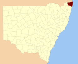
  • Rous County, New South Wales — Infobox Australian cadastral name = Rous state = New South Wales caption = Location in New South Wales near nw = Merivale (Qld) near n = Ward (Qld) near ne = Pacific Ocean near e = Pacific Ocean near se = Pacific Ocean near s = Richmond near sw …   Wikipedia

  • Electoral district of Rous — Rous was an electoral district of the Legislative Assembly in the Australian state of New South Wales, created in 1904, replacing Ballina and part of Lismore, and named after Rous County, between the Tweed and Richmond Rivers and Henry John Rous …   Wikipedia

  • County of Merivale — Merivale Queensland Location within Queensland Lands administrative divisions around Mer …   Wikipedia

  • County of Ward, Queensland — Ward Queensland Location within Queensland Lands administrative divisions around Ward …   Wikipedia

  • Henry John Rous — (* 23. Januar 1795; † 19. Juni 1877), ein britischer Marineoffizier und Sportsmann, wurde als zweiter Sohn von John Rous, 1. Earl of Stradbroke, geboren. Er absolvierte seine Schulzeit auf der Westminster School und war zwischen 1808 und ca. 1840 …   Deutsch Wikipedia

  • Henry John Rous — (23 January 1795 ndash; 19 June 1877), British admiral and sportsman, was born the second son of John Rous, 1st Earl of Stradbroke. He was educated at Westminster School, and entered the British navy in 1808, serving as a midshipman in the… …   Wikipedia

  • John Rous, 1st Earl of Stradbroke — (30 May 1750 ndash;27 August 1827), known as Sir John Rous, 6th Baronet, from 1771 to 1796 and as Lord Rous from 1796 to 1821, was a British nobleman, race horse owner and Member of Parliament. Stradbroke was the son of Sir John Rous, 5th Baronet …   Wikipedia

  • Buller County, New South Wales — Infobox Australian cadastral name = Buller state = New South Wales caption = Location in New South Wales near nw = Queensland near n = Queensland near ne = Queensland near e = Rous near se = Richmond near s = Drake near sw = Clive near w =… …   Wikipedia

  • Drake County, New South Wales — Infobox Australian cadastral name = Drake state = New South Wales caption = Location in New South Wales near nw = Buller near n = Buller near ne = Rous near e = Richmond near se = Clarence near s = Gresham near sw = Gough near w = CliveDrake… …   Wikipedia

  • Richmond County, New South Wales — Infobox Australian cadastral name = Richmond state = New South Wales caption = Location in New South Wales near nw = Buller near n = Rous near ne = Pacific Ocean near e = Pacific Ocean near se = Pacific Ocean near s = Clarence near sw = Drake… …   Wikipedia

Share the article and excerpts

Direct link
https://en-academic.com/dic.nsf/enwiki/11583940 Do a right-click on the link above
and select “Copy Link”