- County of Bentinck
-
Bentinck
Queensland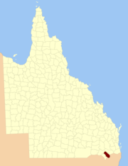
Location within QueenslandLands administrative divisions around Bentinck Marsh Merivale Merivale Clive Bentinck Buller (NSW) Clive Clive (NSW) Clive (NSW) The County of Bentinck is a county located on the southern boundary of the state of Queensland, Australia. Like all counties in Queensland, it is a non-functional administrative unit, that is used mainly for the purpose of registering land titles. The county was named in 1838 after William Cavendish-Bentinck, 3rd Duke of Portland[1], who served as Prime Minister of Great Britain twice, in 1783 and again between 1807 and 1809. Population centres within the County of Bentinck include the towns of Stanthorpe, Wallangarra, Glen Aplin, Applethorpe and Inglewood.[2]
Parishes
See also
References
- ^ "Place name details: Bentinck". Queensland Government (Department of Environment and Resource Management). 4 March 2008. http://www.derm.qld.gov.au/property/placenames/detail.php?id=2331. Retrieved 2009-11-04.
- ^ Darling Downs District, County of Bentinck Maps - B3 Series at Queensland Archives.
Categories:- Counties of Queensland
- Queensland geography stubs

Wikimedia Foundation. 2010.