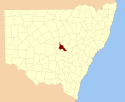
Kennedy County

Kennedy County
Kennedy
New South Wales
Kennedy NSW.PNG
Location in New South Wales
Lands administrative divisions around Kennedy
Flinders Oxley Narromine
Flinders Kennedy Gordon
Cunningham Cunningham Ashburnham

Kennedy County is one of the 141 Cadastral divisions of New South Wales. It is located to the west of the Bogan River in the area around Tottenham and Tullamore.

Kennedy County was named in honour of the explorer Edmund Besley Court Kennedy (1818-1848).[1]

Parishes within this county

A full list of parishes found within this county; their current LGA and mapping coordinates to the approximate centre of each location is as follows:

Parish LGA Coordinates
Albert Lachlan Shire 32°24′54″S 147°30′04″E / 32.415°S 147.50111°E / -32.415; 147.50111 (Albert)
Babathnil Lachlan Shire 32°31′54″S 147°26′04″E / 32.53167°S 147.43444°E / -32.53167; 147.43444 (Babathnil)
Beaconsfield Lachlan Shire 32°14′54″S 147°21′04″E / 32.24833°S 147.35111°E / -32.24833; 147.35111 (Beaconsfield)
Belardery Parkes Shire 32°46′54″S 148°00′04″E / 32.78167°S 148.00111°E / -32.78167; 148.00111 (Belardery)
Bentinck Parkes Shire 32°29′54″S 147°37′04″E / 32.49833°S 147.61778°E / -32.49833; 147.61778 (Bentinck)
Beugamel Parkes Shire 32°39′54″S 147°47′04″E / 32.665°S 147.78444°E / -32.665; 147.78444 (Beugamel)
Boona Lachlan Shire 32°37′54″S 147°12′04″E / 32.63167°S 147.20111°E / -32.63167; 147.20111 (Boona)
Braalghy Lachlan Shire 32°34′54″S 147°18′04″E / 32.58167°S 147.30111°E / -32.58167; 147.30111 (Braalghy)
Bulbodney Lachlan Shire 32°29′54″S 147°15′04″E / 32.49833°S 147.25111°E / -32.49833; 147.25111 (Bulbodney)
Burdenda Lachlan Shire 32°01′54″S 147°20′04″E / 32.03167°S 147.33444°E / -32.03167; 147.33444 (Burdenda)
Burra Lachlan Shire 32°42′54″S 147°24′04″E / 32.715°S 147.40111°E / -32.715; 147.40111 (Burra)
Burrill Parkes Shire 32°48′54″S 148°13′04″E / 32.815°S 148.21778°E / -32.815; 148.21778 (Burrill)
Carolina Lachlan Shire 32°09′54″S 147°26′04″E / 32.165°S 147.43444°E / -32.165; 147.43444 (Carolina)
Cavendish Lachlan Shire 32°25′54″S 143°32′04″E / 32.43167°S 143.53444°E / -32.43167; 143.53444 (Cavendish)
Cookopie Parkes Shire 32°44′54″S 148°08′04″E / 32.74833°S 148.13444°E / -32.74833; 148.13444 (Cookopie)
Coradgery West Parkes Shire 32°52′54″S 147°52′04″E / 32.88167°S 147.86778°E / -32.88167; 147.86778 (Coradgery West)
Coradgery Parkes Shire 32°48′54″S 148°00′04″E / 32.815°S 148.00111°E / -32.815; 148.00111 (Coradgery)
Dandaloo Lachlan Shire 32°14′54″S 147°30′04″E / 32.24833°S 147.50111°E / -32.24833; 147.50111 (Dandaloo)
Davison Parkes Shire 32°59′54″S 148°11′04″E / 32.99833°S 148.18444°E / -32.99833; 148.18444 (Davison)
Derribong Lachlan Shire 32°19′54″S 147°38′04″E / 32.33167°S 147.63444°E / -32.33167; 147.63444 (Derribong)
Euchabil Parkes Shire 32°40′54″S 147°52′04″E / 32.68167°S 147.86778°E / -32.68167; 147.86778 (Euchabil)
Fitzroy Lachlan Shire 32°40′54″S 147°28′04″E / 32.68167°S 147.46778°E / -32.68167; 147.46778 (Fitzroy)
Genanaguy Parkes Shire 32°41′54″S 148°05′04″E / 32.69833°S 148.08444°E / -32.69833; 148.08444 (Genanaguy)
Genaren Parkes Shire 32°34′54″S 147°49′04″E / 32.58167°S 147.81778°E / -32.58167; 147.81778 (Genaren)
Gillenbine Lachlan Shire 32°43′54″S 147°29′04″E / 32.73167°S 147.48444°E / -32.73167; 147.48444 (Gillenbine)
Gobondry Parkes Shire 32°45′54″S 147°34′04″E / 32.765°S 147.56778°E / -32.765; 147.56778 (Gobondry)
Graddle Parkes Shire 32°28′54″S 147°55′04″E / 32.48167°S 147.91778°E / -32.48167; 147.91778 (Graddle)
Hartington Lachlan Shire 32°22′54″S 147°14′04″E / 32.38167°S 147.23444°E / -32.38167; 147.23444 (Hartington)
Hastings Parkes Shire 32°24′54″S 147°39′04″E / 32.415°S 147.65111°E / -32.415; 147.65111 (Hastings)
Hawarden Lachlan Shire 32°23′54″S 147°21′04″E / 32.39833°S 147.35111°E / -32.39833; 147.35111 (Hawarden)
Houston Parkes Shire 32°56′54″S 148°18′04″E / 32.94833°S 148.30111°E / -32.94833; 148.30111 (Houston)
Kadina Parkes Shire 32°52′54″S 148°18′04″E / 32.88167°S 148.30111°E / -32.88167; 148.30111 (Kadina)
Limestone Parkes Shire 32°59′54″S 148°03′04″E / 32.99833°S 148.05111°E / -32.99833; 148.05111 (Limestone)
Merilba Bogan Shire 32°00′54″S 147°15′04″E / 32.015°S 147.25111°E / -32.015; 147.25111 (Merilba)
Meryula Lachlan Shire 32°14′54″S 147°16′04″E / 32.24833°S 147.26778°E / -32.24833; 147.26778 (Meryula)
Mickibri Parkes Shire 32°52′54″S 148°11′04″E / 32.88167°S 148.18444°E / -32.88167; 148.18444 (Mickibri)
Mickimill Lachlan Shire 32°38′54″S 147°24′04″E / 32.64833°S 147.40111°E / -32.64833; 147.40111 (Mickimill)
Mingelo Lachlan Shire 32°07′54″S 147°15′04″E / 32.13167°S 147.25111°E / -32.13167; 147.25111 (Mingelo)
Mingerong Parkes Shire 32°41′54″S 148°00′04″E / 32.69833°S 148.00111°E / -32.69833; 148.00111 (Mingerong)
Moodana South Lachlan Shire 32°10′54″S 147°19′04″E / 32.18167°S 147.31778°E / -32.18167; 147.31778 (Moodana South)
Moodana Lachlan Shire 32°06′54″S 147°21′04″E / 32.115°S 147.35111°E / -32.115; 147.35111 (Moodana)
Mungerie Parkes Shire 32°36′54″S 148°02′04″E / 32.615°S 148.03444°E / -32.615; 148.03444 (Mungerie)
Ormonde Parkes Shire 32°29′54″S 147°43′04″E / 32.49833°S 147.71778°E / -32.49833; 147.71778 (Ormonde)
Ossory Parkes Shire 32°26′54″S 147°44′04″E / 32.44833°S 147.73444°E / -32.44833; 147.73444 (Ossory)
Redcliffe Parkes Shire 32°45′54″S 147°41′04″E / 32.765°S 147.68444°E / -32.765; 147.68444 (Redcliffe)
Russell Parkes Shire 32°36′54″S 147°43′04″E / 32.615°S 147.71778°E / -32.615; 147.71778 (Russell)
Salisbury Parkes Shire 32°46′54″S 147°44′04″E / 32.78167°S 147.73444°E / -32.78167; 147.73444 (Salisbury)
Sarsfield Lachlan Shire 32°33′54″S 147°24′04″E / 32.565°S 147.40111°E / -32.565; 147.40111 (Sarsfield)
Somerset Lachlan Shire 32°37′54″S 147°29′04″E / 32.63167°S 147.48444°E / -32.63167; 147.48444 (Somerset)
Stanley Parkes Shire 32°37′54″S 147°37′04″E / 32.63167°S 147.61778°E / -32.63167; 147.61778 (Stanley)
Strahorn Parkes Shire 32°35′54″S 147°56′04″E / 32.59833°S 147.93444°E / -32.59833; 147.93444 (Strahorn)
Tabratong Lachlan Shire 32°14′54″S 147°27′04″E / 32.24833°S 147.45111°E / -32.24833; 147.45111 (Tabratong)
Talingaboolba Lachlan Shire 32°32′54″S 147°02′04″E / 32.54833°S 147.03444°E / -32.54833; 147.03444 (Talingaboolba)
Tanilogo Parkes Shire 32°47′54″S 147°52′04″E / 32.79833°S 147.86778°E / -32.79833; 147.86778 (Tanilogo)
Tout Lachlan Shire 32°43′54″S 147°25′04″E / 32.73167°S 147.41778°E / -32.73167; 147.41778 (Tout)
Wellwood Parkes Shire 32°27′54″S 147°38′04″E / 32.465°S 147.63444°E / -32.465; 147.63444 (Wellwood)
Weridgery Parkes Shire 32°59′54″S 148°02′04″E / 32.99833°S 148.03444°E / -32.99833; 148.03444 (Weridgery)
Willanbalang Parkes Shire 32°27′54″S 147°50′04″E / 32.465°S 147.83444°E / -32.465; 147.83444 (Willanbalang)
Wilmatha Lachlan Shire 32°32′54″S 147°08′04″E / 32.54833°S 147.13444°E / -32.54833; 147.13444 (Wilmatha)
Wombin Parkes Shire 32°50′54″S 148°03′04″E / 32.84833°S 148.05111°E / -32.84833; 148.05111 (Wombin)
Yralla Lachlan Shire 32°29′54″S 147°32′04″E / 32.49833°S 147.53444°E / -32.49833; 147.53444 (Yralla)

References

  1. ^ Geographical Names Board of NSW

Wikimedia Foundation. 2010.

Игры ⚽ Нужен реферат?

Look at other dictionaries:

  • Kennedy County, New South Wales — Infobox Australian cadastral name = Kennedy state = New South Wales caption = Location in New South Wales near nw = Flinders near n = Oxley near ne = Narromine near e = Gordon near se = Ashburnham near s = Cunningham near sw = Cunningham near w …   Wikipedia

  • County Route 501 (New Jersey) — County Route 501 Route information Length: 53.07 mi[1] (85.41 km) …   Wikipedia

  • County Wexford — Contae Loch Garman Coat of arms …   Wikipedia

  • County of Riverside v. McLaughlin — Supreme Court of the United States Argued January 17, 1991 Decided …   Wikipedia

  • County of Sacramento v. Lewis — Supreme Court of the United States Argued December 9, 1997 Decided May …   Wikipedia

  • County Cricket Ground, Southampton — County Ground Ground information Location Southampton, Hampshire Demolished 2001 Capacity 7,000 End names City End Northlands Road End …   Wikipedia

  • County Route 505 (New Jersey) — County Route 505 Route information Length: 20.64 mi[1] (33.22 km) …   Wikipedia

  • Kennedy Road — may refer to:Transportation *Kennedy Road, Hong Kong *Kennedy Road (Toronto) *Kennedy Road, Eastern Cape *Peel Regional Road 16 in Peel Region and Dufferin County in Ontario is also called Kennedy Road (as well as Kennedy Road North and Kennedy… …   Wikipedia

  • Kennedy Township, Pennsylvania — Kennedy Township is a township in Allegheny County, Pennsylvania, United States. It is a suburb of Pittsburgh. The population was 7,504 at the 2000 census. Kennedy Township is part of the Montour School District. Montour s David E. Williams… …   Wikipedia

  • County Route 527 (New Jersey) — County Route 527 Route information …   Wikipedia

Share the article and excerpts

Direct link
Do a right-click on the link above
and select “Copy Link”