Gordon County, New South Wales

Gordon County, New South Wales
Gordon
New South Wales
Gordon NSW.PNG
Location in New South Wales
Lands administrative divisions around Gordon
Narromine Lincoln Bligh
Kennedy Gordon Wellington
Ashburnham Ashburnham Wellington

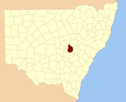
Gordon County is one of the 141 Cadastral divisions of New South Wales. The Macquarie River is the north-eastern boundary.

Gordon County was named in honour of George Hamilton Gordon, Fourth Earl of Aberdeen (1784-1860).[1]

Parishes within this county

A full list of parishes found within this county; their current LGA and mapping coordinates to the approximate centre of each location is as follows:

Parish LGA Coordinates
Belmore Cabonne Shire Council 32°37′54″S 148°25′04″E / 32.63167°S 148.41778°E / -32.63167; 148.41778 (Belmore)
Benolong City of Dubbo 32°25′54″S 148°39′04″E / 32.43167°S 148.65111°E / -32.43167; 148.65111 (Benolong)
Benya Cabonne Shire Council 32°57′54″S 148°33′04″E / 32.965°S 148.55111°E / -32.965; 148.55111 (Benya)
Bolderogery Cabonne Shire Council 32°48′54″S 148°36′04″E / 32.815°S 148.60111°E / -32.815; 148.60111 (Bolderogery)
Buckinbah Cabonne Shire Council 32°47′54″S 148°40′04″E / 32.79833°S 148.66778°E / -32.79833; 148.66778 (Buckinbah)
Burgoon Cabonne Shire Council 32°51′54″S 148°38′04″E / 32.865°S 148.63444°E / -32.865; 148.63444 (Burgoon)
Burrawong Cabonne Shire Council 32°50′54″S 148°44′04″E / 32.84833°S 148.73444°E / -32.84833; 148.73444 (Burrawong)
Caloma City of Dubbo 32°29′54″S 148°30′04″E / 32.49833°S 148.50111°E / -32.49833; 148.50111 (Caloma)
Cardington Cabonne Shire Council 32°50′54″S 148°55′04″E / 32.84833°S 148.91778°E / -32.84833; 148.91778 (Cardington)
Catombal Wellington Council 32°47′54″S 148°49′04″E / 32.79833°S 148.81778°E / -32.79833; 148.81778 (Catombal)
Cullen City of Dubbo 32°25′54″S 148°24′04″E / 32.43167°S 148.40111°E / -32.43167; 148.40111 (Cullen)
Curra Wellington Council 32°36′54″S 148°54′04″E / 32.615°S 148.90111°E / -32.615; 148.90111 (Curra)
Dilga Cabonne Shire Council 32°56′54″S 148°40′04″E / 32.94833°S 148.66778°E / -32.94833; 148.66778 (Dilga)
Draway City of Dubbo 32°35′54″S 148°35′04″E / 32.59833°S 148.58444°E / -32.59833; 148.58444 (Draway)
City of Dubbo City of Dubbo 32°13′54″S 148°35′04″E / 32.23167°S 148.58444°E / -32.23167; 148.58444 (City of Dubbo)
Eurimbula Cabonne Shire Council 32°53′54″S 148°49′04″E / 32.89833°S 148.81778°E / -32.89833; 148.81778 (Eurimbula)
Ganoo Wellington Council 32°39′54″S 148°41′04″E / 32.665°S 148.68444°E / -32.665; 148.68444 (Ganoo)
Gilgal City of Dubbo 32°31′54″S 148°38′04″E / 32.53167°S 148.63444°E / -32.53167; 148.63444 (Gilgal)
Gullengambel City of Dubbo 32°36′54″S 148°32′04″E / 32.615°S 148.53444°E / -32.615; 148.53444 (Gullengambel)
Gundy Wellington Council 32°34′54″S 148°51′04″E / 32.58167°S 148.85111°E / -32.58167; 148.85111 (Gundy)
Hyandra Cabonne Shire Council 32°52′54″S 148°26′04″E / 32.88167°S 148.43444°E / -32.88167; 148.43444 (Hyandra)
Loombah Wellington Council 32°45′54″S 148°44′04″E / 32.765°S 148.73444°E / -32.765; 148.73444 (Loombah)
Narragal Wellington Council 32°46′54″S 148°57′04″E / 32.78167°S 148.95111°E / -32.78167; 148.95111 (Narragal)
Neurea Wellington Council 32°46′54″S 148°53′04″E / 32.78167°S 148.88444°E / -32.78167; 148.88444 (Neurea)
Obley Cabonne Shire Council 32°44′54″S 148°36′04″E / 32.74833°S 148.60111°E / -32.74833; 148.60111 (Obley)
Oxley City of Dubbo 32°25′54″S 148°32′04″E / 32.43167°S 148.53444°E / -32.43167; 148.53444 (Oxley)
Ponto Wellington Council 32°30′54″S 148°49′04″E / 32.515°S 148.81778°E / -32.515; 148.81778 (Ponto)
Redbank Wellington Council 32°34′54″S 148°44′04″E / 32.58167°S 148.73444°E / -32.58167; 148.73444 (Redbank)
Roche City of Dubbo 32°30′54″S 148°33′04″E / 32.515°S 148.55111°E / -32.515; 148.55111 (Roche)
Rocky Ponds Cabonne Shire Council 31°59′54″S 148°30′04″E / 31.99833°S 148.50111°E / -31.99833; 148.50111 (Rocky Ponds)
Strathorn Cabonne Shire Council 32°44′54″S 148°23′04″E / 32.74833°S 148.38444°E / -32.74833; 148.38444 (Strathorn)
Terrabella Wellington Council 32°28′54″S 148°45′04″E / 32.48167°S 148.75111°E / -32.48167; 148.75111 (Terrabella)
The Gap Cabonne Shire Council 32°56′54″S 148°45′04″E / 32.94833°S 148.75111°E / -32.94833; 148.75111 (The Gap)
The Springs City of Dubbo 32°29′54″S 148°39′04″E / 32.49833°S 148.65111°E / -32.49833; 148.65111 (The Springs)
Veech Wellington Council 32°40′54″S 148°46′04″E / 32.68167°S 148.76778°E / -32.68167; 148.76778 (Veech)
Wagstaff Cabonne Shire Council 32°46′54″S 148°31′04″E / 32.78167°S 148.51778°E / -32.78167; 148.51778 (Wagstaff)
Wandawandong Cabonne Shire Council 32°44′54″S 148°32′04″E / 32.74833°S 148.53444°E / -32.74833; 148.53444 (Wandawandong)
Warraberry Cabonne Shire Council 32°53′54″S 148°33′04″E / 32.89833°S 148.55111°E / -32.89833; 148.55111 (Warraberry)
Whylandra City of Dubbo 32°20′54″S 148°34′04″E / 32.34833°S 148.56778°E / -32.34833; 148.56778 (Whylandra)

References

  1. ^ Geographical Names Board of NSW

Wikimedia Foundation. 2010.

Игры ⚽ Поможем написать курсовую

Look at other dictionaries:

  • Narromine County, New South Wales — Infobox Australian cadastral name = Narromine state = New South Wales caption = Location in New South Wales near nw = Oxley near n = Ewenmar near ne = Lincoln near e = Gordon near se = Gordon near s = Kennedy near sw = Kennedy near w =… …   Wikipedia

  • Bligh County, New South Wales — Infobox Australian cadastral name = Bligh state = New South Wales caption = Location in New South Wales near nw = Napier near n = Pottinger near ne = Buckland near e = Brisbane near se = Phillip near s = Wellington near sw = Gordon near w =… …   Wikipedia

  • Richmond County, New South Wales — Infobox Australian cadastral name = Richmond state = New South Wales caption = Location in New South Wales near nw = Buller near n = Rous near ne = Pacific Ocean near e = Pacific Ocean near se = Pacific Ocean near s = Clarence near sw = Drake… …   Wikipedia

  • Lincoln County, New South Wales — Infobox Australian cadastral name = Lincoln state = New South Wales caption = Location in New South Wales near nw = Ewenmar near n = Gowen near ne = Napier near e = Bligh near se = Bligh near s = Bligh near sw = Gordon near w = Narromine Lincoln… …   Wikipedia

  • Ashburnham County, New South Wales — Infobox Australian cadastral name = Ashburnham state = New South Wales caption = Location in New South Wales near nw = Kennedy near n = Gordon near ne = Wellington near w = Cunningham near e = Bathurst near sw = Gipps near s = Forbes near se =… …   Wikipedia

  • Kennedy County, New South Wales — Infobox Australian cadastral name = Kennedy state = New South Wales caption = Location in New South Wales near nw = Flinders near n = Oxley near ne = Narromine near e = Gordon near se = Ashburnham near s = Cunningham near sw = Cunningham near w …   Wikipedia

  • Cumberland County, New South Wales — Map of all coordinates from Google Map of all coordinates from Bing Export all coordinates as KML …   Wikipedia

  • Livingstone County, New South Wales — Map of all coordinates from Google Map of all coordinates from Bing Export all coordinates as KML …   Wikipedia

  • Wellington County, New South Wales — Infobox Australian cadastral name = Wellington state = New South Wales caption = Location in New South Wales near nw = Gordon near n = Bligh near ne = Phillip near e = Roxburgh near se = Roxburgh near s = Bathurst near sw = Ashburnham near w =… …   Wikipedia

  • New South Wales Legislative Assembly electoral districts — The New South Wales Legislative Assembly is elected from 93 single member electorates called districts. Current districts This is a list of districts for the 2007 general election.* Albury * Auburn * Ballina * Balmain (1880 1894: Balmain; 1894… …   Wikipedia

Share the article and excerpts

Direct link
Do a right-click on the link above
and select “Copy Link”