- North Sulawesi
-
North Sulawesi
Sulawesi Utara— Province — 
SealMotto: Si Tou Timou Tumou Tou (Minahasan)
(Human purpose in life is to nurture and educate others)Location of North Sulawesi in Indonesia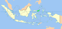
Coordinates: 1°15′N 124°50′E / 1.25°N 124.833°ECoordinates: 1°15′N 124°50′E / 1.25°N 124.833°E Country Indonesia Capital Manado Government - Governor Sinyo Harry Sarundajang Area - Total 15,359 km2 (5,930.1 sq mi) Population (2010)[1] - Total 2,265,937 - Density 147.5/km2 (382.1/sq mi) Demographics - Ethnic groups Minahasan, Mongondow, Sangir, Talaud - Religion Protestantism (65%), Islam (27%), Roman Catholicism (6%), Confucianism (1%), Buddhism & Hinduism (1%) - Languages Indonesian (official) Time zone WITA (UTC+8) Website www.sulut.go.id North Sulawesi (Indonesian: Sulawesi Utara) is a province of Indonesia. It is on the island of Sulawesi, and borders the province of Gorontalo to the west (originally a part of North Sulawesi until 2001 when it became its own province). The islands of Sangihe and Talaud form the northern part of the province, which border Davao del Sur in the Philippines.
The capital and largest city in North Sulawesi is Manado. In 2006 the province's population was about two million [1], of whom about 70% were Christian (predominantly Protestantism with a sizeable Catholic minority), one of the few exceptions in predominantly Muslim Indonesia. There are also Muslim, Hindu, and Buddhist minorities. The largest ethnic group is Minahasan.
Contents
Demographics
North Sulawesi recorded 2,265,937 people in the decennial 2010 Census, with 1,157,551 males and 1,108,378 females, growing at 1.41% over the previous census.[2] The slowest growing regency was that of the Sangihe Islands. The province's largest city is Manado with 408,354 people.
Administrative areas
North Sulawesi is divided into ten regencies (Indonesian: kabupaten) and four cities (Indonesian: kotamadya).
Regencies (seat):
- Minahasa (Tondano)
- North Minahasa (Airmadidi)
- South Minahasa (Amurang)
- Southeast Minahasa (Ratahan)
- Talaud Islands (Melonguane)
- Bolaang Mongondow (Kotamobagu)
- North Bolaang Mongondow (Boroko)
- South Bolaang Mongondow (Molibagu)
- Sangihe Islands (Tahuna)
- Sitaro Islands (Ondong)
Cities:
Biodiversity
A 30 hectares of land at Paniki will be built as a biodiversity garden in an effort to restore the role of plantations and environment by showcasing a number of unique seeds and plants. It has been declared at the minister of agriculture's letter number 07/PD.320/M/1/2011 dated January 3, 2011.[3]
References
- ^ a b http://sulut.bps.go.id/terkinipenduduk2.cfm Accessed July 26, 2007.
- ^ BPS
- ^ http://www.antaranews.com/en/news/69674/n-sulawesi-to-have-biodiversity-garden
External links
- (Indonesian) Sulut
- (Indonesian) Official site
- (Indonesian) Kotamobagu
- North Sulawesi travel guide from Wikitravel
- 12 surprises in North Sulawesi
North Sulawesi Capital: ManadoRegencies
Bolaang Mongondow • East Bolaang Mongondow • North Bolaang Mongondow • South Bolaang Mongondow • Minahasa • North Minahasa • South Minahasa • Southeast Minahasa • Sangihe Islands • Sitaro Islands • Talaud Islands

Cities
Provinces of Indonesia Sumatra Aceh · Bangka–Belitung Islands · Bengkulu · Jambi · Lampung · North Sumatra · Riau · Riau Islands · South Sumatra · West SumatraJava Kalimantan Lesser Sunda Sulawesi Central Sulawesi · Gorontalo · North Sulawesi · South East Sulawesi · South Sulawesi · West SulawesiMaluku Western New Guinea Papua · West PapuaCategories:- Regencies of North Sulawesi
- Provinces of Indonesia
- North Sulawesi

Wikimedia Foundation. 2010.