- Clyde Dam
-
Clyde Dam 
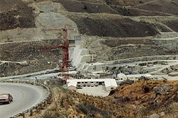
Clyde Dam from the east, looking westLocation of Clyde Dam Location Clyde, Otago, New Zealand Coordinates 45°10′46″S 169°18′25″E / 45.179314°S 169.306955°ECoordinates: 45°10′46″S 169°18′25″E / 45.179314°S 169.306955°E Dam and spillways Type of dam Concrete gravity dam Height 100 m (330 ft) Length 490 m (1,610 ft) Crest width 10 m (33 ft) Base width 70 m (230 ft) Impounds Clutha River Reservoir Creates Lake Dunstan Surface area 26 km2 (10 sq mi) Power station Operator(s) Contact Energy Commission date 1992 Turbines 4× 10⁸ MW Francis turbines Installed capacity 432 MW[1] Annual generation 2,100 GWh The Clyde Dam, New Zealand's third largest hydroelectric dam, is built on the Clutha River near the town of Clyde. It is owned and operated by Contact Energy.
Contents
History
There was considerable controversy when the dam was planned because it would flood many houses and orchards upstream at Cromwell,[2] as well as the scenic Cromwell Gorge, which was a highlight of the then young but growing New Zealand tourism industry. Construction also required replacement of a stretch of highway[3] and the closure of the Otago Central Railway beyond Clyde, though materials for the dam would provide significant traffic for the rest of the line which was experiencing a drop in freight tonnage. To mitigate these problems, the Kirk Labour government decided a low dam should be built at Clyde. This decision was overturned by the following National government, who preferred a high dam.[4]
There was also debate about whether the dam was needed. National's support for a controversial aluminium smelter at Aramoana, another of Prime Minister Sir Robert Muldoon's Think Big projects of the late 1970s and early 1980s, was one justification propounded for the dam.[4] An initial grant of water rights for the dam was overturned by the High Court following an appeal by landowners. National overturned this decision, after bargaining for the support of Social Credit (who had initially opposed a high dam), in the Clutha Development (Clyde Dam) Empowering Act 1982.[2][4] The Act was later repealed by the following National government on 1 October 1991, when it was superseded by the Resource Management Act 1991. [5]
The dam was constructed between 1982 and 1993. Filling it was done in four controlled stages beginning in April 1992, and completed the following year, creating Lake Dunstan.[2] The power station has a capacity of four 120 MW francis turbines (for a total of 480 MW), but is only allowed to run 432 MW due to resource consent conditions. The dam is built such that two further penstocks and turbines can be installed, but if they were installed there will not be enough water to keep them running.[citation needed]
During construction, the adjacent rock was discovered to be microfractured, because of an earthquake fault running underneath the dam site. The dam was redesigned, losing a sluice channel and cutting its generation capacity from 612 MW to 432 MW. A slip joint was built into the dam to accommodate 1-2 metres of potential ground movement,[6][7] and a large amount of slurry cement was pumped into the rock to stop water leaks. This additional work was one reason for a major project cost over-run, which made the dam the most expensive in New Zealand. The other areas of over-run were due to stabilisation of landslides in the Cromwell Gorge.[8][9] There are over 18 km of tunnels throughout the gorge for draining purposes. Because of all this extra work it overran the budget by nearly an extra 50% and delayed the filling of Lake Dunstan by a few years.
Maintenance workers accidentally activated fire alarms in the dam on 15 December 2008. The alarms triggered the release of a large bank of CO2 cylinders at the generators, flooding the equipment with the gas. Extractor fans to clear the CO2 then activated, and firefighters with breathing apparatus and gas detectors checked through the dam to ensure it had cleared.[10]
Trivia
The Clyde Dam, while still under construction, was used for on-location filming in the 1985 movie Shaker Run.[11]
See also
References
- ^ Hydroelectricity: turning water into power, Contact Energy.
- ^ a b c Gilchrist, Shane (31 January 2009). "Reflections on Lake Dunstan". Otago Daily Times. http://www.odt.co.nz/lifestyle/magazine/41410/reflections-lake-dunstan. Retrieved 2009-03-18.
- ^ Dai Redshaw (1997). Sustainable Energy, New Zealand Science Monthly, March 1997.
- ^ a b c Aynsley John Kellow (1996). Transforming power: the politics of electricity planning. Cambridge University Press. ISBN 9780521471220.
- ^ "Resource Management Act 1991 No 69 - New Zealand Legislation". http://www.legislation.govt.nz/act/public/1991/0069/latest/contents. Retrieved 30 December 2010.
- ^ Fault Provisioned Design Examples, Chapter 7 in Key Points for Rational Design for Civil-Infrastructures near Seismic Faults Reflecting Soil-Structure Interaction Features, Japan Society for Promoting Science, 2007.
- ^ Eileen McSaveney. Earthquakes - Building for earthquake resistance, Te Ara - the Encyclopedia of New Zealand. Updated 2 March 2009.
- ^ Michael J. Crozier. Landslides - People and landslides, Te Ara - the Encyclopedia of New Zealand. Updated 2 March 2009.
- ^ Vicki Hyde (1990). Slip Sliding Away, New Zealand Science Monthly, November 1990 (Via Archive.org).
- ^ Brown, Diane (16 December 2008). "Gas cylinders inadvertently activated at Clyde dam". Otago Daily Times. http://www.odt.co.nz/the-regions/central-otago/36210/gas-cylinders-inadvertently-activated-clyde-dam. Retrieved 2008-12-15.
- ^ "Shaker Run". IMDB. http://www.imdb.com/title/tt0090006/.
Further reading
- Martin, John E, ed (1991). People, Politics and Power Stations. Wellington: Bridget Williams Books Ltd and Electricity Corporation of New Zealand. pp. 316 pages. ISBN 0-908912-16-1.
- Reeves, Trevor; Wolfe, Judith (1994). An Abuse of Power: The Story of the Clyde Dam. Dunedin: Square One Press. ISBN 0-908562-12-8.
- Sheridan, Marion (1995). Dam Dwellers – End of an Era. Twizel: Sheridan Press. pp. 392 pages. ISBN 0-473-03402-6.
External links
- LEARNZ photos showing various stages of the construction
- Timeline of Clutha hydroelectric development
Clutha River Source: Southern Alps — Flows into: Pacific Ocean Administrative areas Towns and settlements (upstream to downstream) Wanaka · Albert Town · Luggate · Lowburn · Cromwell · Clyde · Alexandra · Roxburgh Hydro · Roxburgh · Teviot · Ettrick · Millers Flat · Beaumont · Tuapeka Mouth · Clydevale · Balclutha · Stirling · KaitangataMajor tributaries (upstream to downstream by confluence) Makarora River · Matukituki River · Hawea River · Cardrona River · Lindis River · Kawarau River · Manuherikia River · Teviot River · Tuapeka River · Pomahaka River · Waitahuna RiverLakes in catchment (upstream to downstream by location or tributary) Islands in catchment (upstream to downstream by location or tributary) Other features (upstream to downstream) Longest New Zealand rivers 1: Waikato · 2: Clutha / Mata-Au · 3: Whanganui · 4: Taieri · 5: Rangitikei · 6: Mataura · 7: Waiau (Southland) · 8: Clarence · 9: Waitaki · 10: OretiCategories:- Dams in New Zealand
- Hydroelectric power stations in New Zealand
- Buildings and structures in the Otago Region
- Dam controversies
- Clutha River
Wikimedia Foundation. 2010.


