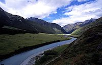
- Matukituki River
-
The Matukituki River is found in the Southern Alps of New Zealand's South Island. It flows for 30 kilometres from Mount Aspiring National Park into the southwestern edge of Lake Wanaka just after passing under the West Wanaka bridge.
The Matukituki River valley is home to a ski resort (Treble Cone), a jetboat operator (River Journeys) and numerous tramping (walking) trails providing access to most notably the Rob Roy Glacier and the Dart Saddle.
Maori called Mount Aspiring, Tititea, meaning steep peak of glistening white. Throughout the year the maori would come from Foveaux Strait and Coastal Otago to the inland lakes to collect Kakapo (night parrot), Kākā, Kereru (wood pigeon) and Tui from the forest. For the first 200 years of Maori settlement there would also have been moa along the forest edges. Kati Mamoe and Kai Tahu both had named settlements around the shores of Lakes Wanaka and Hawea, including Nehenehe (literally meaning forest), on the north side of the mouth of the Matukituki River. There are several sites on the lake shore with ovens for cooking ti rakau (cabbage tree) roots. The first European to see Mount Aspiring/Tititea was government surveyor John Turnbull Thompson in 1857. The first European to explore the West Matukituki Valley was James Hector in 1862. Farming began in the valley in the 1870s.
Most of the Southern Alps/Ka Tiritiri o te Moana started over 220 million years ago as sediment and rock on top of volcanic rocks on the seafloor. Under intense heat and pressure the rock was consolidated, then uplifted to form the Main Divide. The present landscape was shaped by glacial processes during the Ice Ages, when huge glaciers filled and scoured out the valleys. Beech is the dominant forest in the Matukituki Valley. Red beech prefers warm valley sites, and is common just below Aspiring Hut. Mountain beech dominates the drier, eastern end of the valley, while silver beech increases towards the wetter, western end. Ferns and mosses are a feature of the usually open forest. Above the tree line, at about 1100 metres, stunted, sub-alpine shrub land gives way to alpine tussock grasslands and fell fields.
Insect-eating birds such as fantail/piwakawaka, tomtit/miromiro and Rifleman/titipounamu, thrive in beech forest and seed-eating Kakariki (parakeet) are common in the red beech. The paradise shelduck/putakitaki is a conspicuous and noisy feature of the river flats, and in summer spur-winged plover and oystercatcher/torea are common on farmland and along the drive from Wanaka.
Clutha River Source: Southern Alps — Flows into: Pacific OceanAdministrative areas Towns and settlements (upstream to downstream) Wanaka · Albert Town · Luggate · Lowburn · Cromwell · Clyde · Alexandra · Roxburgh Hydro · Roxburgh · Teviot · Ettrick · Millers Flat · Beaumont · Tuapeka Mouth · Clydevale · Balclutha · Stirling · KaitangataMajor tributaries (upstream to downstream by confluence) Makarora River · Matukituki River · Hawea River · Cardrona River · Lindis River · Kawarau River · Manuherikia River · Teviot River · Tuapeka River · Pomahaka River · Waitahuna RiverLakes in catchment (upstream to downstream by location or tributary) Islands in catchment (upstream to downstream by location or tributary) Other features (upstream to downstream) Longest New Zealand rivers 1: Waikato · 2: Clutha / Mata-Au · 3: Whanganui · 4: Taieri · 5: Rangitikei · 6: Mataura · 7: Waiau (Southland) · 8: Clarence · 9: Waitaki · 10: OretiCategories:- Rivers of the Otago Region
- Mount Aspiring National Park
Wikimedia Foundation. 2010.


