- Millers Flat
-
 Millers Flat
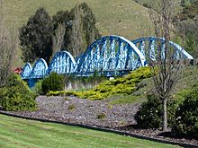 The heritage-listed Millers Flat Bridge, a four span steel truss bridge which crosses the Clutha River.
Millers Flat is a small town (population about 200) in inland Otago, in the South Island of New Zealand. It is located on the Clutha River, 17 kilometres south of Roxburgh. Fruit growing is the main industry in the area. Most of the town lies on the north bank of the Clutha; the main road - State Highway 8 passes close by on the river's other bank. The Roxburgh Branch railway used to pass through the town; it was opened to Millers Flat in 1925 and was the terminus for approximately two and a half years, until the section to Roxburgh was opened. The line was closed in 1968, though the town's station platform and some of the railway formation still exist.
Millers Flat was originally called Ovens Hill; its current name is in honour of an early European settler, Walter Miller, who farmed in the area from about 1849.
Approximately 8km downstream of Millers Flat on the Clutha River are the remains of the Horseshoe Bend Gold Diggings, now largely remembered for the story of "Somebody's Darling" and the Lonely Graves.
Early in 1865 the body of a young man was discovered at Rag Beach, upstream and on the opposite side of the river from the present site of the Lonely Graves. An inquest held on 22 February 1865 in the Horseshoe Hotel determined the body to be that of Charles Alms who had fallen in the river at Mutton Town Creek, some considerable distance upstream. Alms, a butcher from the Nevis had been swimming cattle across the river when he had been thrown from his horse and washed away. The body was buried in an unmarked grave and the gravesite remained untended. Later in that same year a miner named William Rigney arrived at Horseshoe Bend, and with John Ord erected a fence of rough manuka poles around the previously untended grave. Rigney obtained a piece of black pine and made a simple headstone for the grave. With a four inch nail he inscribed the words "Somebody's Darling lies buried here." In 1903 a marble headstone was erected. William Rigney died in 1912 and was buried beside "Somebody's Darling."[1][2][3][4]
References
- ^ http://www.historic.org.nz/magazinefeatures/2004summer/2004_summer_cemeteries.htm
- ^ http://www.nextstop.com/p/RMKh_K3bmL8/somebodys-darling-grave/
- ^ http://www.TeAra.govt.nz/otago-places/14/3
- ^ http://nzlibrariescatalogue.natlib.govt.nz/cgi-bin/Pwebrecon.cgi?BBID=5036738
External links
 Media related to Millers Flat at Wikimedia Commons
Coordinates: 45°40′S 169°25′E / 45.667°S 169.417°E
Categories:- Populated places in New Zealand
- Otago Region
- Otago Region geography stubs


Wikimedia Foundation. 2010.