- New York State Route 361
-
NYS Route 361
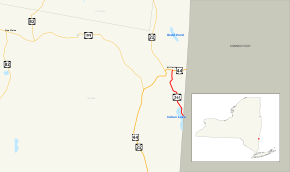
Map of northeastern Dutchess County with NY 361 highlighted in redRoute information Maintained by NYSDOT Length: 2.4 mi[4] (3.9 km) Existed: ca. 1936[1][2] – April 1, 1980[3] Major junctions South end:  Route 361 at North East
North end:  US 44 in Millerton
Location Counties: Dutchess Highway system Numbered highways in New York
Interstate • U.S. • N.Y. (former) • Reference • County←  NY 360
NY 362  →
→New York State Route 361 (NY 361) was a state highway located in Dutchess County, New York, United States. The southern terminus of the route was at the Connecticut state line, where it continued to Sharon, Connecticut, as Route 361. The northern terminus was at U.S. Route 44 (US 44) in Millerton. NY 361 was designated in the mid-1930s and removed from the state highway system and replaced with County Route 62 (CR 62) in 1980 as part of a large-scale highway maintenance swap between the New York State Department of Transportation and the Dutchess County highway department.
Contents
Route description
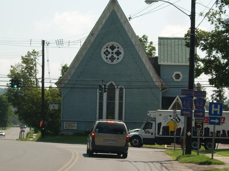
 Current view of NY 361's northern terminus at US 44
NY 361 began as a continuation of Connecticut Route 361 adjacent to the bi-state water body of Indian Lake in the town of North East. The route traveled northward on Sharon Road, paralleling the Webatuck Creek to Millerton, where it became South Maple Avenue and terminated at an intersection with US 44 (Main Street). The road itself, however, continued northward to NY 22 in the hamlet of Mount Riga as North Maple Avenue and, outside the village, Rudd Pond Road, connecting Millerton to the Rudd Pond area of Taconic State Park.
History
NY 361 was assigned ca. 1936 to a short north–south highway connecting US 44 in Millerton to Connecticut Route 4 (later Route 361) at the Connecticut state line.[1][2] The route remained unchanged until April 1, 1980, when the route was transferred to Dutchess County as part of a large scale highway maintenance swap. As part of the swap, NY 361, the routing of NY 82A from Amenia to Pine Plains, NY 402, and three reference routes near the hamlets of Barrytown (near Red Hook), Pine Plains, and East Park (near Hyde Park) were given to the county by the New York State Department of Transportation in exchange for maintenance of the segment of NY 82 between NY 199 and the Columbia County line. Also exchanged was a county route bypassing Millbrook to the northwest (which became NY 44A and later US 44), the portion of the Salt Point Turnpike north of Smith Street in Poughkeepsie (NY 115), and Spackenkill Road between US 9 and NY 376 in Poughkeepsie (NY 113).[3] NY 361, now under the control of Dutchess County, was redesignated as CR 62 and extended north to NY 22 in Mount Riga.[5]
Major intersections
The entire route was in Dutchess County.
Location Mile[4] Destinations Notes North East 0.0 Route 361Continuation into Connecticut Millerton 2.4  US 44 / CR 62
1.000 mi = 1.609 km; 1.000 km = 0.621 mi See also
References
- ^ a b Sun Oil Company (1935). Road Map & Historical Guide – New York (Map). Cartography by Rand McNally and Company.
- ^ a b Standard Oil Company (1936). New York (Map). Cartography by General Drafting.
- ^ a b New York State Legislature. "Highway Law, Article 12, Section 341". http://public.leginfo.state.ny.us/menugetf.cgi?COMMONQUERY=LAWS. Retrieved January 22, 2008.
- ^ a b Google, Inc. Google Maps – overview map of former NY 361 (Map). Cartography by Google, Inc. http://maps.google.com/maps?hl=en&q=from:+CR-62/S+Maple+Ave+%4041.952973,+-73.506166+to:+CR-62/Sharon+Rd+%4041.922390,+-73.496630&um=1&ie=UTF-8&sa=N&tab=wl. Retrieved March 22, 2008.
- ^ Google, Inc. Google Maps – overview map of Dutchess CR 62 (Map). Cartography by Google, Inc. http://maps.google.com/maps?sourceid=navclient&ie=UTF-8&rlz=1T4ADBF_enUS232US232&q=from%3A%20CR-62%2FRudd%20Pond%20Rd%20%4041.994147%2C%20-73.520046%20to%3A%20CR-62%2FSharon%20Rd%20%4041.922390%2C%20-73.496630&um=1&sa=N&tab=wl. Retrieved August 21, 2008.
External links
Categories:- Former state highways in New York
- Transportation in Dutchess County, New York


Wikimedia Foundation. 2010.