- Nanjō, Okinawa
-
Nanjō
南城市
Nanjoo— City — 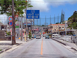

FlagLocation of Nanjō in Okinawa Prefecture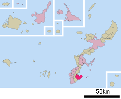

 Nanjō
NanjōCoordinates: 26°8′40″N 127°46′1″E / 26.14444°N 127.76694°ECoordinates: 26°8′40″N 127°46′1″E / 26.14444°N 127.76694°E Country Japan Region Kyūshū Prefecture Okinawa Prefecture Government – Mayor Keishun Koja Area – Total 49.69 km2 (19.2 sq mi) Population (January 31, 2007) – Total 40,695 – Density 819.0/km2 (2,121.2/sq mi) Time zone Japan Standard Time (UTC+9) City symbols - Tree Ebony - Flower Hibiscus - Flowering tree Common Gardenia - Fish Grouper Phone number 098-948-7111 Address Nanjō-shi, Tamagusuku, Aza Fusato 143
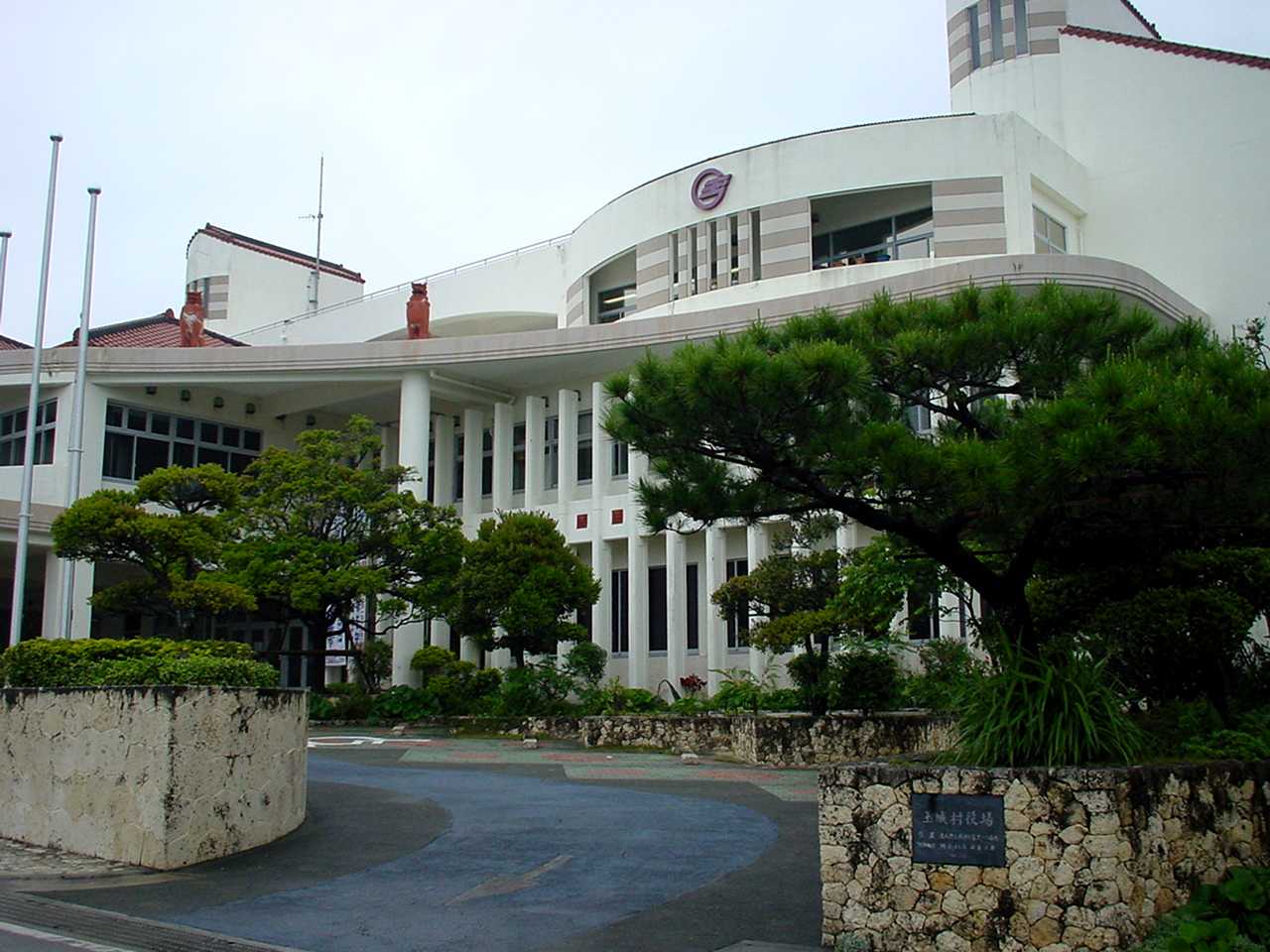
901-0695Website Nanjō City Hall  Nanjō city hall
Nanjō (南城市 Nanjō-shi, Okinawan: Nanjoo) is a city in the southern part of Okinawa Island in Okinawa Prefecture, Japan.
It was formed on January 1, 2006, from the merger of the town of Sashiki, and the villages of Chinen, Ōzato and Tamagusuku, all from Shimajiri District.
Nanjō has an area of 49.69 km² and, as of the date of its inception, a population of 40,759, and a population density of 820.3 per km².
Translated literally, the name Nanjō means something like "the city of the southern castle". Many castle ruins, called gusuku in the Okinawan language, can be found throughout the city.
Of the eleven cities in Okinawa Prefecture, Nanjō has the smallest population. It does not have a separate police station nor a high school. For those services, citizens have to refer to the neighbouring towns of Yonabaru and Yaese. The city hosts a fire station responsible for Chinen, Ōzato and Tamagusuku and parts of Yaese, while Sashiki is served by a separate station.
The city's main economical activities are agriculture and tourism. Important crops include sugarcane, for sugar and vinegar production, and turmeric, a popular medicinal herb in Okinawa. Several turmeric processing plants are based in the city, producing semi-processed goods to be used by industries on the mainland or consumer products like tea and dietary supplements.
Contents
Geography
Nanjō is a city located in the southern region (南部 - Nanbu) of Okinawa's main island. The isle of Kudaka, off the coast of Chinen, also belongs to the city.
Districts
- Chinen (知念)
- Azama (安座真)
- Umino (海野)
- Gushiken (具志堅)
- Kudaka (久高)
- Kudeken (久手堅)
- Kuhara (久原)
- Shikiya (志喜屋)
- China (知名)
- Chinen (知念)
- Yamazato (山里)
- Yoshitomi (吉富)
- Ōzato (大里)
- Furugen (古堅)
- Inamine (稲嶺)
- Minei (嶺井)
- Nakama (仲間))
- Ōzato (大里)
- Ōshiro (大城)
- Takahira (高平)
- Sashiki (佐敷)
- Fusozaki (富祖崎)
- Ibara (伊原)
- Kaneku (兼久)
- Nakaiho (仲伊保)
- Okoku (小谷)
- Sashiki (佐敷)
- Shinkai (新開)
- Shinzato (新里)
- Tedokon (手登根)
- Tsuhako (津波古)
- Yabiku (屋比久)
- Tamagusuku (玉城)
- Aichi (愛地)
- Funakosi (船越)
- Fusato (富里)
- Horikawa (堀川)
- Hyakuna (百名)
- Itokazu (糸数)
- Kakinohana (垣花)
- Kibaru (喜良原)
- Maekawa (前川)
- Nakayama (中山)
- Nakandakari (仲村渠)
- Ō (奥武)
- Oyakebaru (親慶原)
- Shikenbaru (志堅原)
- Tamagusuku (玉城)
- Tōyama (當山)
- Yakabu (屋嘉部)
Surrounding Municipalities
Tourism and Culture
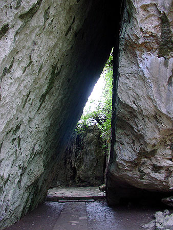
 Sefa-utaki
Located in Chinen, the seifa-utaki (斎場御嶽) shrine is listed by UNESCO as part of the Gusuku Sites and Related Properties of the Kingdom of Ryukyu World Heritage Site. It was believed to be a sacred place, from where one could see the "Isle of the Gods". In the shrine, noro priestesses from Shuri Castle would pray for the well-being of the king and the kingdom.
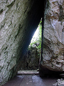
In Tamagusuku, the Gyokusendō cave with a total length of five kilometers is known for its beautiful stalagmites and stalactites. 850 metres of these caves are open to tourists. The cave is located inside a theme park, named Okinawa World. Other attractions of the theme park are native dances such as Eisa, a traditional Ryūkyū-style village and a Habu snake zoo.
Also located in Tamagusku, the Itokazu-Abuchiragama cave was used in World War II as a bomb shelter by soldiers and civilians alike. It is also open to tourists. Himeyuri Students were used as nurses in this location among others.
The isle of Kudaka, also called Isle of the Gods, can be accessed from Azama Port, located in Chinen.
From the isle of Ōjima, in Tamagusuku, one can board a "Glass boat", a boat with a transparent floor used in marine-life observations.
As golf is a popular sport in Okinawa, a famous site in Nanjō is the Ryūkyū Golf Club, with three 27-hole courses. Every spring, the Ryūkyū Golf Club welcomes the Daikin Orchid Ladies Golf Tournament.
Gusuku in Nanjō
- Tamagusuku-gusuku
- Sahiki gusuku
- Ōzato gusuku
- Kakinohana gusuku
Beaches
- Azama Sansan Beach
- Hyakuna Beach
- Mībaru Beach
Historical Facts
Shō Hashi was the leader of Sashiki-gusuku before uniting the Ryūkyū Kingdom.
- 1908 (Meiji Era, year 41) One year after Okinawa Prefecture is established by an Imperial Edict, the Magiri system is abolished and the villages of Chinen, Ōzato, Sashiki and Tamagusuku are created.
- 1945 (Showa Era, year 20) After the Battle of Okinawa, Chinen is given the status of city by the occuping American Army. In the following year, it reverts to being a village.
- 1949 (Showa Era, year 24) The districts (字) of Yonabaru, Ueyonabaru and Itarashiki are severed from the village of Ōzato to form the new village of Yonabaru.
- 1980 (Showa Era, year 55) Sashiki receives the status of town.
- 2005 (Heisei Era, year 17), March The name Nanjō-shi was selected for the soon to be founded city.
- 2006 (Heisei Era, year 18), January 1 Foundation of the city of Nanjō.
Sister Town
 Tamaki, Mie Prefecture since 1993 (domestic)
In kanji, Tamaki has the same spelling as Tamagusuku (玉城). Neither name follows the standard readings for the kanji in Japanese.
Access
By plane
Passengers traveling from mainland Japan and overseas arrive at Naha Airport.
By bus
Several lines serve the city of Nanjo, departing from the bus terminals at Naha and Itoman.
External links
- (Japanese) Nanjo City home page
- (Japanese) Gyokusendo - Okinawa World
- (Japanese) Wel Sunpia
- (English) Ryukyu Golf Club
 Okinawa Prefecture
Cities - Ginowan
- Ishigaki
- Itoman
- Miyakojima
- Nago
- Naha (capital)
- Nanjō
- Okinawa
- Tomigusuku
- Urasoe
- Uruma

Districts Categories:- Cities in Okinawa Prefecture
- Chinen (知念)


Wikimedia Foundation. 2010.