- Coldean
-
Coordinates: 50°51′41″N 0°06′36″W / 50.86139°N 0.11°W
Coldean 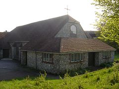
Saint Mary Magdalene ChurchUnitary authority Brighton and Hove Ceremonial county East Sussex Region South East Country England Sovereign state United Kingdom Post town BRIGHTON Postcode district BN1 Dialling code 01273 Police Sussex Fire East Sussex Ambulance South East Coast EU Parliament South East England List of places: UK • England • East Sussex Coldean is a suburb of Brighton and Hove, England and is one of its most well defined and self contained. Unlike its neighbours Moulsecoomb or Hollingbury, it sits in a steep sided valley ("dean" is Anglo-Saxon for valley) on the extreme north-east of the city. It is surrounded by the Wild Park, the Ditchling Road ridge and the estate of Stanmer Park.
On its southern border, where it abuts the busy Lewes Road, there is an expanse of urban parkland. Until the early 1990s, this was the main A27 road, although this number and trunk status has since been allocated to the "Brighton bypass" relief road, a short distance to the north of the old road.
Coldean benefits from a small primary school with morning and afternoon nursery classes, a local church, St Mary Magdalene that is very involved with the local community and a care home for elderly and long term sick patients. There is a small post office/newsagent, convenience store/chemist, hairdressers and doctors surgery at the heart of Coldean just off Hawkhurst Road, which is on the main bus route through Coldean. Bus numbers; 24, 26 and 46 stop regular, and all go into town and now the N25 night bus runs through the night to provide the student residents of Varley Halls a direct link to the city centre overnight. There is a pub upon entry from the Lewes Road, The Hikers Rest which serves food, has a car park and beer garden. A fast food outlet selling Pizza, Kebabs, Burgers, Fish & Chips amongst other foods next door to the pub and also on Park Road a second convenience store, bookmakers, newsagent and a private dental technician. A new Coldean library opened in late July 2008 and now provides a base for community meetings, a monthly councillor surgery and housing information, as well as a rich stock of fiction, non-fiction, local history and children's resources.
Cultural references
Coldean is referenced in the chapter "The Concluding Chaotic Conundrum of the Coldean Cat" of the fantasy novel The Brightonomicon.
External links
Categories:- Districts of Brighton and Hove
- East Sussex geography stubs

Wikimedia Foundation. 2010.