- Chalton, Hampshire
-
Coordinates: 50°56′21″N 0°57′37″W / 50.93926°N 0.96027°W
Chalton
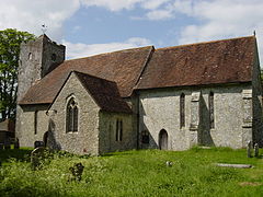
St. Michael & All Angels
 Chalton shown within Hampshire
OS grid reference SU731160 Parish Clanfield District East Hampshire Shire county Hampshire Region South East Country England Sovereign state United Kingdom Post town WATERLOOVILLE Postcode district PO8 Dialling code 023 Police Hampshire Fire Hampshire Ambulance South Central EU Parliament South East England UK Parliament East Hampshire List of places: UK • England • Hampshire Chalton is a small village and civil parish in the East Hampshire district of Hampshire, England. It is 2.3 miles (3.7 km) northeast of Horndean, just east of the A3 road.
The nearest railway station is 3.1 miles (5 km) south of the village, at Rowlands Castle.
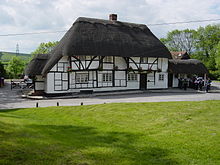
Chalton green and The Red Lion pub
The village pub, The Red Lion, is believed to be the oldest in Hampshire, dating from the 16th century, though possibly earlier.[1] The Church of England Parish Church of St. Michael and All Angels has a thirteenth century chancel;[2] the registers include burials in woollen cloth from 1678-1746. Clanfield and Chalton parishes were amalgamated 1932. Chalton was listed as part of the 'Hundred of Finchdean' in the Domesday Book.
On Windmill Hill, Hampshire near Chalton is Chalton Windmill which stands at 193 metres above sea level. Also near Chalton, is Butser Ancient Farm and the area around Chalton is home to many ancient sites.
The Staunton Way footpath goes past Chalton from Queen Elizabeth Country Park which is close to the village.
The Admiralty Shutter Telegraph Line had a semaphore line station at Chalton.
Admiral Richard Goodwin Keats, famous for his actions at the Battle of Algeciras Bay in 1801 was born in Chalton in 1757.
References
External links
- Hampshire Treasures Volume 6 (East Hampshire) pages 89, 91, 92, 93, 94 and 95
- Stained Glass Windows at St. Michael Chalton, Hampshire
- Chalton Hampshire
- A history of Chalton
Towns, villages and hamlets in the East Hampshire District of Hampshire, England  Adhurst · Alton · Arford · Ashley · Barford · Beech · Bentley · Bentworth · Binsted · Blackmoor · Blacknest · Blendworth · Bordean · Bordon · Bradley · Bramshott · Bucks Horn Oak · Buriton · Burkham · Catherington · Chalton · Chawton · Clanfield · Cold Ash Hill · Colemore · Conford · Ditcham · Durford Wood · East Meon · East Tisted · East Worldham · Empshott · Farringdon · Finchdean · Flexcombe · Four Marks · Froxfield Green · Froyle · Golden Pot · Grayshott · Greatham · Griggs Green · Hartley Mauditt · Hawkley · Headley · Headley Down · High Cross · Holybourne · Hollywater · Horndean · Idsworth · Isington · Kingsley · Kitwood · Langrish · Lasham · Lindford · Liphook · Liss · Liss Forest · Longmoor · Lovedean · Lower Wield · Medstead · Monkwood · Neatham · Newton Valence · North Street · Nursted · Oakhanger · Oakshott · Passfield · Petersfield · Priors Dean · Privett · Ramsdean · Ropley · Ropley Dean · Rowland's Castle · Selborne · Shalden · Sheet · Sleaford · Soldridge · South Hay · Southrope · Standford · Stansted · Steep · Steep Marsh · Stroud · Thedden · Upper Wield · West Liss · West Tisted · West Worldham · Weston · Wheatley · Whitehill · Wivelrod · WyckCategories:
- East Hampshire
- Villages in Hampshire
- Hampshire geography stubs
Wikimedia Foundation. 2010.


