- Dozmary Pool
-
Dozmary Pool 
Location Bodmin Moor, Cornwall Coordinates 50°32′32″N 4°33′01″W / 50.5423°N 4.5502°WCoordinates: 50°32′32″N 4°33′01″W / 50.5423°N 4.5502°W Basin countries United Kingdom Surface area 14.9 ha / 36.8 acres Shore length1 1.5 km / 0.9 mi Surface elevation 268 m / 879 ft Islands none 1 Shore length is not a well-defined measure. 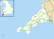
 Map showing the location of Dozmary Pool within Cornwall.
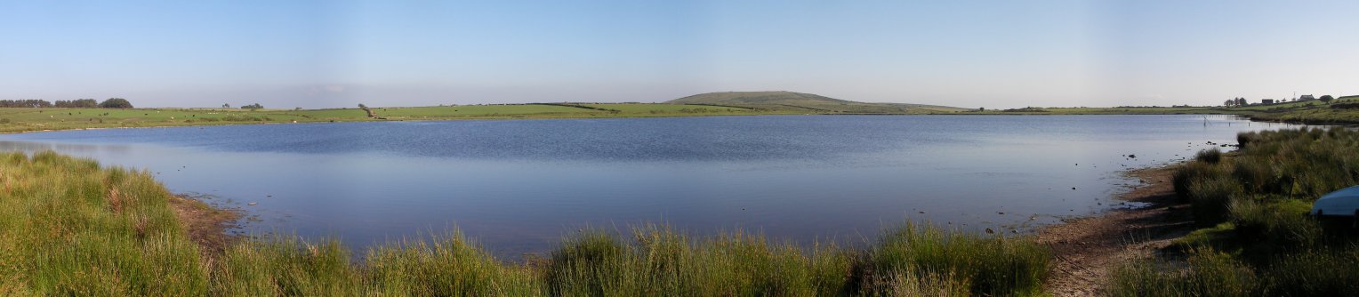
:Some of the information shown above makes use of the following source(s):[1]Dozmary Pool is a small lake on Bodmin Moor, Cornwall, UK situated 16.9 km/10.5 mi from the sea.[1] It lies about 15 km northeast of Bodmin and 2 km south of Bolventor: it originated in the post-glacial period. The outflow from the pool is into Colliford Lake. At one time the name was often spelled 'Dozmaré': at the end of the 19th century it was described by Sabine Baring-Gould as abounding in fish and surrounded by numerous remains of the working of flint in the Stone Age.[2]
It is also a Site of Special Scientific Interest noted for its biological interest.[3]
Legendary tales
It is one site that is claimed to be the home of the Lady of the Lake. According to the legend, it is here that King Arthur rowed out to the Lady of the Lake and received the sword Excalibur. The pool is also the place where Bedivere returned Excalibur as Arthur lay dying after the Battle of Camlann.[4] Another tale associated with Dozmary Pool is that of Jan Tregeagle. In search of deviant exploits, Tregeagle makes a Faustian bargain with the Devil and is given money and power. At the conclusion of his life, he is damned to the bottomless Dozmary Pool, where he is tormented to this day; it is said that Tregagle's ghost can still be heard howling across the moor.[5] (He was set the task of dipping the water out of Dozmary Pool with a leaking limpet shell, but decided to escape to Roche Rock before being set another task, weaving ropes from the sand of Gwenor Cove.)
Carew's account
Richard Carew describes the pool as a mile or more in circumference. He tells how some gentlemen of the district experimented to see whether the pool contained fish and found none, only eels, also that it was nowhere more than nine feet deep.[6]
References
- ^ a b "Data sheet:Dozmary Pool". http://www.uklakes.net/lakeinfo.php?WBID=46232&DM=&CE=&sSE=&DM=Y. Retrieved April 3, 2009.
- ^ Baring-Gould, S. (1899). A Book of the West ... Vol. 2: Cornwall. London: Methuen, p. 87
- ^ "Dozmary Pool". Natural England. 1986. http://www.sssi.naturalengland.org.uk/citation/citation_photo/1000726.pdf. Retrieved 27 October 2011.
- ^ Bishop, Ray (1994). North Cornwall Camera. Bodmin: Bossiney Books. ISBN 0948158 97 2.
- ^ Thompson, E.V. (1984). 100 years on Bodmin Moor. St Teath: Bossiney Books. pp. p9. ISBN 0 906456 90 8.
- ^ Carew, Richard (1602) The Survey of Cornwall; ed. with an introduction by F. E. Halliday. London: Andrew Melrose, 1953; reissued in 1969 by Adams & Dart, London ISBN 0-238-78941-1; pp. 192-93
Geological Sites of Special Scientific Interest in Cornwall Summary SSSIs Belowda Beacon) · Boscawen · Cameron Quarry · Carn Grey Rock and Quarry · Chapel Downs (St Martin's) · Clicker Tor Quarry · Cligga Head · Crocadon Quarry · Cuckoo Rock to Turbot Point · De Lank Quarries · Folly Rocks · Great Wheal Fortune · Greystone Quarry · Harbour Cove · Hawkstor Pit · Hingston Down Quarry & Consols · Lidcott Mine · Luxulyan Quarry · Mulberry Downs Quarry · Penlee Quarry · Polyne Quarry · Polyphant · Porthleven Cliffs · Porthleven Cliffs East · Porthloo · St. Agnes Beacon Pits · St Erth Sand Pits · South Terras Mine · Tater-Du · Tintagel · Tregargus Quarries · Trevone Bay · Trevose Head and Constantine Bay • Viverdon Quarry · Wheal Alfred · Wheal Gorland · Wheal Martyn · Wheal Penrose · Yeolmbridge
Neighbouring areas Cornwall Portal Sites of Special Scientific Interest in Cornwall and the Isles of Scilly - Annet
- Belowda Beacon
- Breney Common
- Crowhill Valley
- Cudden Point to Prussia Cove
- De Lank Quarries
- Dozmary Pool
- Draynes Wood
- Goonhilly Downs
- Goss and Tregoss Moors
- Gugh
- Loe Pool
- Lower Fal & Helford Intertidal
- Marazion Marsh
- Penlee Point
- Plymouth Sound, Shores and Cliffs
- Polyne Quarry
- Porthloo
- Roche Rock
- St. Michael's Mount
- Stepper Point
- Swanpool
- Sylvia's Meadow
- Talland Barton
- Tater–du
- Teän
- Tintagel
- Treen Cliff
- Trevose Head and Constantine Bay
- Upper Fal Estuary and Woods
- Upper Fowey Valley
Neighbouring areas: Sites of Special Scientific Interest in Devon · Sites of Special Scientific Interest in Somerset 
This article about a Site of Special Scientific Interest is a stub. You can help Wikipedia by expanding it.