- Marazion Marsh
-
Coordinates: 50°07′31″N 5°28′33″W / 50.1253°N 5.4758°W
Marazion Marsh
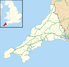
 Marazion Marsh shown within England
OS grid reference SW510312 List of places: UK • England Marazion Marsh is a Royal Society for the Protection of Birds (RSPB) reserve situated in a shallow river valley, half a kilometre to the west of Marazion, Cornwall, England, UK. It is separated from the coast by a shingle bar and small sand dune system and contains Cornwall’s largest reed bed.
Contents
History
About 63 acres (25 ha) were successfully drained for agriculture by Dr Richard Moyle when in May 1793 the first drainage pipes were laid. Of this 36 acres (15 ha) of the area was tidal marsh which was between the sandy embankment formed by the sea and the croft. Open trenches were dug across the marsh in June and in one of the drains, at a depth of three feet, was found a pot containing around one thousand copper coins. The corroded coins have been tentatively identified as having been issued by the Emperor Victorinus (reigned 268 to 270 or 271): ″... these coins were much injured by the corrosion of the marine acid, but several were still perfect enough to trace the outlines of the Emperor″.[1]
In 1951 the marsh was designated a Site of Special Scientific Interest for its biological interest.[2]
The most significant threat to the marsh at present is the runoff of soil particles in the area near the wetland. Because of this, the marsh's catchment is recognized as a Catchment Sensitive Farming Area, and the UK government works with farmers in the area to help control erosion.[3]
Notable birds
Up to five bitterns overwinter at the reserve,[4] although the reed-bed is below the minimum size of twenty ha required by this species for breeding. Funding for the management of the reserve has been received from the EU LIFE Programme's Bittern Project (2001-2007).[5]
Reference
- ^ Moyle, R. (1795) "Transactions of The Society of Arts, Manufactures and Commerce", vol. XIV, 1796, pp. 154-73. In: Penhallurick, R. D., Guest, P. & Wells, N. (eds.) 2009. Ancient and Early Medieval Coins from Cornwall and Scilly. (Special Publication No. 45.) London: Royal Numismatic Society
- ^ "Marazion Marsh". Natural England. 1985. http://www.sssi.naturalengland.org.uk/citation/citation_photo/1004035.pdf. Retrieved 27 October 2011.
- ^ Horsey, S (January 2006). "Case Studies Aimed at Reducing Diffuse Water Pollution from Agriculture in England". DEFRA. http://archive.defra.gov.uk/foodfarm/landmanage/water/csf/documents/dwpa-report.pdf. Retrieved 26 September 2011.
- ^ "Cornwall Birding". http://www.cornwall-birding.co.uk/. Retrieved 26 September 2011.
- ^ Clark N and Bean A, ed (2004). Cornwall's Biodiversity Volume 3: Action Plans. Truro: Environmental Records Centre for Cornwall and the Isles of Scilly.
External links
Sites of Special Scientific Interest in Cornwall and the Isles of Scilly - Annet
- Belowda Beacon
- Breney Common
- Crowhill Valley
- Cudden Point to Prussia Cove
- De Lank Quarries
- Dozmary Pool
- Draynes Wood
- Goonhilly Downs
- Goss and Tregoss Moors
- Gugh
- Loe Pool
- Lower Fal & Helford Intertidal
- Marazion Marsh
- Penlee Point
- Plymouth Sound, Shores and Cliffs
- Polyne Quarry
- Porthloo
- Roche Rock
- St. Michael's Mount
- Stepper Point
- Swanpool
- Sylvia's Meadow
- Talland Barton
- Tater–du
- Teän
- Tintagel
- Treen Cliff
- Trevose Head and Constantine Bay
- Upper Fal Estuary and Woods
- Upper Fowey Valley
Categories:- Royal Society for the Protection of Birds reserves in England
- Nature reserves in Cornwall
- Sites of Special Scientific Interest in Cornwall
- Special Protection Areas in England
Wikimedia Foundation. 2010.

