Mangere Island

Mangere Island
Mangere Island
Māngere (Moriori/Māori)

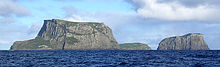
Mangere Island (left) and Little Mangere (right)
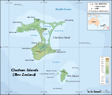
Map showing location of Mangere Island.
Geography
Coordinates 44°16′10″S 176°17′40″W / 44.2695°S 176.2945°W / -44.2695; -176.2945
Archipelago Chatham Islands
Area 1.13 km2 (0.436 sq mi)
Highest elevation 292 m (958 ft)
Highest point Whakapa
Country
Demographics
Population 0

Mangere Island is part of the Chatham Islands archipelago, located 800 kilometres (497 mi) east of New Zealand's South Island and has an area of 113 hectares (279 acres). The island lies off the west coast of Pitt Island, 45 kilometres (28 mi) south-east of the main settlement in the Chathams, Waitangi, on Chatham Island.

Mangere and nearby Tapuaenuku (Little Mangere) are the eroded remains of an ancient volcano of pliocene age. The island's highest point, Whakapa, is 292 metres (958 ft) above sea level.

Forested until the 1890s, the island was largely cleared for sheep grazing[citation needed]. Rabbits and then cats were also introduced but later died out. Farmed until 1966, the island was then purchased by the New Zealand government and gazetted as a Nature Reserve[1]. The last sheep were removed in 1968 and restoration of the island started in 1973 and is ongoing. Several endemic Chatham Island bird species have since been reintroduced to the island, Chatham Snipe in 1970, Black Robin in 1976, Chatham Island Tomtit in 1987 and Shore Plover in the 1990s.

Coordinates: 44°16′10″S 176°17′40″W / 44.2695°S 176.2945°W / -44.2695; -176.2945

See also

References

  1. ^ Mangere Island restoration (from the Department of Conservation website)

External links


Wikimedia Foundation. 2010.

Игры ⚽ Нужно сделать НИР?

Look at other dictionaries:

  • Little Mangere Island — or Tapueanuku is part of the Chatham Islands chain, located 800 km east of New Zealand s South Island. The island lies off the west coast of Pitt Island, 45 km southeast of the chain s main settlement, Waitangi, on Chatham Island. Less than 15… …   Wikipedia

  • Māngere (New Zealand electorate) — Māngere is a New Zealand Parliamentary electorate, returning one Member of Parliament to the New Zealand House of Representatives. The current MP for Māngere is Su a William Sio[1], elected for the Labour Party. He has held this seat since 2008.… …   Wikipedia

  • Mangere Mountain — seen from Ambury Regional Park. Elevation 106 m (348 ft) …   Wikipedia

  • Mangere Lagoon — seen from Mangere Mountain. Mangere Lagoon is a lagoon in the Manukau Harbour, New Zealand. It occupies a volcanic crater or maar which is part of the Auckland volcanic field. Oval and about 600m long, it has a small restored scoria is …   Wikipedia

  • Mangere River — Mouth Wairua River Basin countries New Zealand Length 12 kilometres (7.5 mi) The Mangere River is a river of the Northland Region of New Zealand s North Island. It flows generally westwards from its sources in hills northwest of …   Wikipedia

  • Mangere (Cook Islands) — Mangere is one of 22 islands in the Aitutaki atoll of the Cook Islands. It is located on the northeastern perimeter of Aitutaki Lagoon to the south of the larger island of Ee, three kilometres to the east of the main island of Aitutaki.… …   Wikipedia

  • Ile Mangere — Île Mangere  Pour l’article homonyme, voir Île Petite Mangere.  Île Mangere L île Mangere à gauche et l île Petite Mangere à d …   Wikipédia en Français

  • Île Mangere —  Pour l’article homonyme, voir Île Petite Mangere.  Île Mangere Vue panoramique de l île Mangere (à gauche) et l île Petite Mangere …   Wikipédia en Français

  • Ile Petite Mangere — Île Petite Mangere  Pour l’article homonyme, voir Île Mangere.  Île Petite Mangere L île Mangere à gauche et l île Petite Mang …   Wikipédia en Français

  • Île Little Mangere — Île Petite Mangere  Pour l’article homonyme, voir Île Mangere.  Île Petite Mangere L île Mangere à gauche et l île Petite Mang …   Wikipédia en Français

Share the article and excerpts

Direct link
Do a right-click on the link above
and select “Copy Link”