Mangere Lagoon

Mangere Lagoon
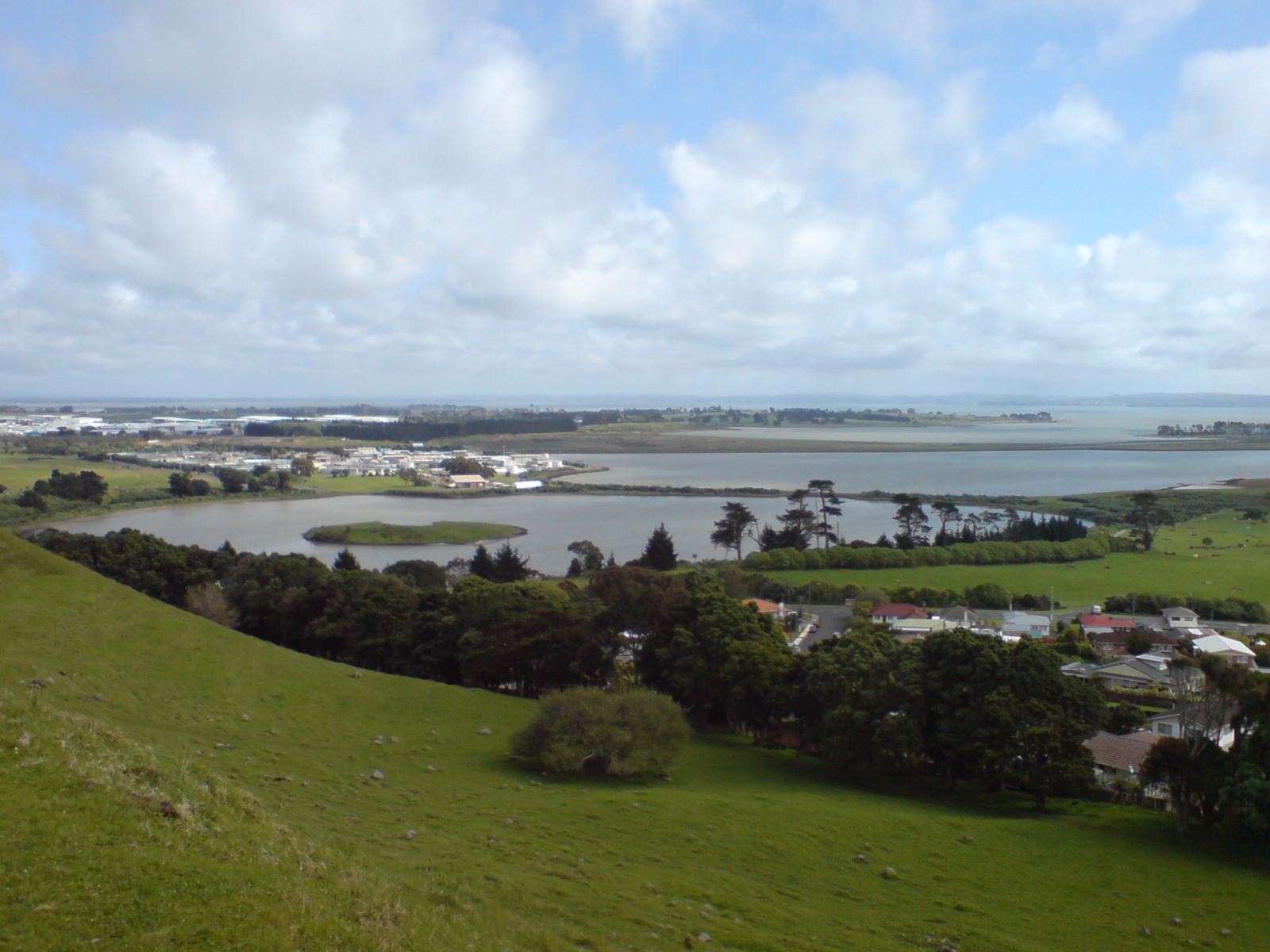
Mangere lagoon seen from Mangere Mountain.

Mangere Lagoon is a lagoon in the Manukau Harbour, New Zealand. It occupies a volcanic crater or maar which is part of the Auckland volcanic field. Oval and about 600m long, it has a small restored scoria island remaining in the centre.[1]

In the 1930s efforts were made to drain the swamp for conversion to pasture, while in the late 1950s, earthworks for sewage sludge ponds in the lagoon removed the scoria cone and the crater was divided into ponds.[1] Public demand for a better sewage treatment system eventually led to a land-based facility, and in 2003, the restoration of the area to a tidal lagoon was completed, with the sludge removed. The scoria cone was rebuilt with an extra flat portion added on the west side as an artificial bird roost.[2][3]

References

  1. ^ a b Mangere Lagoon - City of Fire, insert magazine in the The New Zealand Herald, Friday 15 February 2008
  2. ^ Redemption near for Puketutu - City of Fire, insert magazine in the The New Zealand Herald, Friday 15 February 2008
  3. ^
    • Volcanoes of Auckland: The Essential Guide - Hayward, B.W., Murdoch, G., Maitland, G.; Auckland University Press, 2011.

Coordinates: 36°57′25″S 174°46′39″E / 36.9570251°S 174.7776318°E / -36.9570251; 174.7776318


Wikimedia Foundation. 2010.

Игры ⚽ Поможем решить контрольную работу

Look at other dictionaries:

  • Mangere Mountain — seen from Ambury Regional Park. Elevation 106 m (348 ft) …   Wikipedia

  • Mangere (Cook Islands) — Mangere is one of 22 islands in the Aitutaki atoll of the Cook Islands. It is located on the northeastern perimeter of Aitutaki Lagoon to the south of the larger island of Ee, three kilometres to the east of the main island of Aitutaki.… …   Wikipedia

  • Auckland volcanic field — The Auckland volcanic field is a generally monogenetic volcanic field in the North Island of New Zealand. Basaltic in nature, it underlies much of the metropolitan area of Auckland. The field s many vents have produced a diverse array of… …   Wikipedia

  • Onehunga — For other uses, see Onehunga (disambiguation). Onehunga Onehunga Mall from near the southern end …   Wikipedia

  • Chatham Islands — This article is about an island group of New Zealand. For other islands with this or similar names, see Chatham Island (disambiguation). Chatham Islands Native name: Rekohu, Wharekauri Topographical map of the Chatham Islands …   Wikipedia

  • Chatham Island/Rekohu — Chatham Island redirects here. For other uses, see Chatham Island (disambiguation). Chatham Island Rekohu (Moriori) Wharekauri (Māori) Chatham Island from space …   Wikipedia

  • List of dual place names in New Zealand — The agreed dual name of Te Koko o Kupe / Cloudy Bay remembers both the Māori and British explorations of New Zealand. Many official place names in New Zealand are dual names, incorporating both the original Māori place names and the English names …   Wikipedia

  • Aitutaki — Aitutaki, also traditionally known as Araura, Ararau and Utataki, is one of the Cook Islands, north of Rarotonga. It has a population of approximately 2,000. Aitutaki is the second most visited island of the Cook Islands. The capital (main… …   Wikipedia

  • Ramp meter — Metered ramp on I 894. A Portland, Oregon ramp meter …   Wikipedia

  • Ee (island) — is one of 22 islands in the Aitutaki atoll of the Cook Islands. It is located on the eastern perimeter of Aitutaki Lagoon between the smaller islands of Angarei and Mangere, three kilometres to the east of the main island of Aitutaki …   Wikipedia

Share the article and excerpts

Direct link
Do a right-click on the link above
and select “Copy Link”