- Wainwright Airport (Alaska)
-
Wainwright Airport 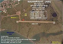
IATA: AIN – ICAO: PAWI – FAA LID: AWI Summary Airport type Public Owner North Slope Borough Serves Wainwright, Alaska Elevation AMSL 41 ft / 12 m Coordinates 70°38′17″N 159°59′41″W / 70.63806°N 159.99472°W Runways Direction Length Surface ft m 5/23 4,494 1,370 Gravel Statistics (2005) Aircraft operations 1,100 Source: Federal Aviation Administration[1] Wainwright Airport (IATA: AIN, ICAO: PAWI, FAA LID: AWI, formerly 5WW) is a public use airport located in Wainwright,[1] a city in the North Slope Borough of the U.S. state of Alaska. The airport is owned by the North Slope Borough.[1]
Although most U.S. airports use the same three-letter location identifier for the FAA and IATA, this airport is assigned AWI by the FAA[1] and AIN by the IATA.[2] The airport's ICAO identifier is PAWI.[3]
Contents
Facilities and aircraft
Wainwright Airport has one runway designated 5/23 with a gravel surface measuring 4,494 by 90 feet (1,370 x 27 m). For the 12-month period ending December 31, 2005, the airport had 1,100 aircraft operations, an average of 91 per month: 73% air taxi and 27% general aviation.[1]
Airlines
- Era Alaska
Top Destinations
Top busiest domestic routes out of NUL
(June 2010 - May 2011) [4]Rank City Passengers Carriers 1  Barrow, AK
3,000 Hageland, Era Alaska History
The airport was built in 1957 to support the Distant Early Warning Line Radar station at Wainwright (LIZ-3). The station was logistically supported by the 711th Aircraft Control and Warning Squadron based at Cape Lisburne Air Force Station, although Point Lay was operated by civilian contract workers.
The radar station was upgraded in the late 1980s with new radars and in 1989 was re-designated part of the North Warning System (NWS) as a Long Range Radar Site, A-16, controlled by the Pacific Air Forces 611th Air Support Group, based at Elmendorf AFB.
The LRR site was inactivated in 2007 due to soil erosion and budget concerns. The airport remains open to support the small settlement.
See also
References
 This article incorporates public domain material from websites or documents of the Air Force Historical Research Agency.
- ^ a b c d e FAA Airport Master Record for AWI (Form 5010 PDF), effective 2009-07-02.
- ^ "AIN / PAWI - Wainwright, Alaska". Great Circle Mapper. http://gc.kls2.com/airport/AIN. Retrieved 2009-08-07.
- ^ "Alaskan ICAO Identifiers". Federal Aviation Administration. http://www.faa.gov/air_traffic/publications/atpubs/LID/L_G2.htm. Retrieved 2009-08-07.
- ^ http://www.transtats.bts.gov/airports.asp?pn=1&Airport=AIN&Airport_Name=Wainwright,%20AK:%20Wainwright%20Airport&carrier=FACTS
External links
- "Diagram of Wainwright Airport" (GIF). Federal Aviation Administration, Alaska Region. 2004-09-30. http://wayback.archive.org/web/http://www.alaska.faa.gov/fai/images/ARPT_DIAGRAMS/AWI.gif.
- FAA Terminal Procedures for AWI, effective 20 October 2011
- Resources for this airport:
- AirNav airport information for PAWI
- ASN accident history for AIN
- FlightAware airport information and live flight tracker for PAWI
- NOAA/NWS latest weather observations for PAWI
- SkyVector aeronautical chart for AWI
Categories:- Airports in North Slope Borough, Alaska
- Radar networks
- Radar stations of the United States Air Force
- Closed facilities of the United States Air Force

Wikimedia Foundation. 2010.