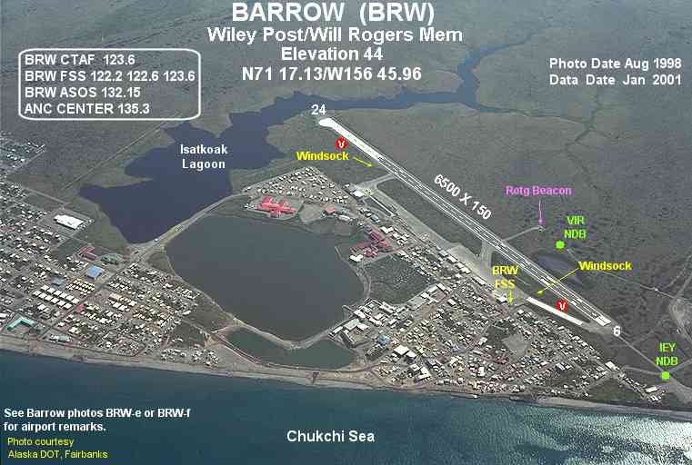
- Wiley Post-Will Rogers Memorial Airport
Infobox Airport
name = Wiley Post-Will Rogers Memorial Airport

IATA = BRW
ICAO = PABR
FAA = BRW
type = Public
owner = State of Alaska DOT&PF - Northern Region
operator =
city-served =
location =Barrow, Alaska
elevation-f = 44
elevation-m = 13
coordinates = coord|71|17|08|N|156|45|58|W|type:airport|display=inline
website =
r1-number = 6/24
r1-length-f = 6,500
r1-length-m = 1,981
r1-surface = Asphalt
stat-year = 2006
stat1-header = Aircraft operations
stat1-data = 11,750
footnotes = Source:Federal Aviation Administration FAA-airport|ID=BRW|use=PU|own=PU|site=50054.3*A, effective 2007-07-05]Wiley Post-Will Rogers Memorial Airport airport codes|BRW|PABR|BRW [ [http://gc.kls2.com/airport/BRW Great Circle Mapper: BRW - Barrow, Alaska (Wiley Post-Will Rogers Memorial Airport)] ] is a public
airport located in Barrow, a city in the North Slope Borough of theU.S. state ofAlaska . It is owned by the state. Situated on theChukchi Sea at alatitude of 71.29°N, the airport is the farthest north of the entire United States.The airport is named after American humorist
Will Rogers and aviatorWiley Post , both of whom died in a plane crash due to inclement weather nearby.Facilities and aircraft
Wiley Post-Will Rogers Memorial Airport has one
asphalt pavedrunway (6/24) measuring 6,500 x 150 ft. (1,981 x 46 m).For the 12-month period ending January 1, 2006, the airport had 11,750 aircraft operations, an average of 32 per day: 51%
air taxi , 38%general aviation , 10% scheduled commercial and <1% military.Airlines and non-stop destinations
*
Alaska Airlines (Anchorage, Fairbanks, Prudhoe Bay)
*Frontier Flying Service (Atqasuk, Nuiqsut, Point Lay, Wainwright) [ [http://www.frontierflying.com/timetable-ffs.pdf Frontier Flying Service: 2007 Timetable] (PDF ). Retrieved 29-Aug-2007.]
*Hageland Aviation Services (Atqasuk, Nuiqsut, Wainwright) [ [http://www.hageland.com/07sched.pdf Hageland Aviation Services: Scheduled Flights] (PDF ). Retrieved 29-Aug-2007.]Cargo airlines
*
Northern Air Cargo References
External links
* [http://www.alaska.faa.gov/fai/images/ARPT_DIAGRAMS/BRW.gifFAA Alaska airport diagram] (
GIF )
*
* [http://pabr.arh.noaa.gov/ National Weather Service Barrow, Alaska]
*
Wikimedia Foundation. 2010.
