- New York State Route 293
-
This article is about the current alignment of NY 293. For the former alignment of NY 293 in Cayuga and Onondaga Counties, see New York State Route 293 (1930–1933).
NYS Route 293
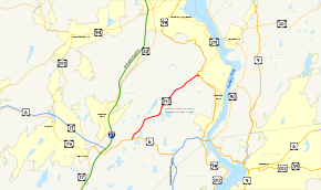
Map of the West Point area with NY 293 highlighted in redRoute information Maintained by NYSDOT Length: 6.82 mi[3] (10.98 km) Existed: ca. 1934[1][2] – present Major junctions South end:  US 6 in Woodbury
North end: 
 US 9W / NY 218 in Highlands
Location Counties: Orange Highway system Numbered highways in New York
Interstate • U.S. • N.Y. (former) • Reference • County←  NY 292
NY 294  →
→New York State Route 293 (NY 293) is a 6.82-mile (10.98 km) state highway located entirely within eastern Orange County, New York, in the United States. The highway starts at U.S. Route 6 (US 6, known as the Long Mountain Parkway) in Woodbury, and heads to the northeast, ending at an intersection with US 9W and NY 218 in the community of Highlands. It does not pass through any notable populated areas as most of the land around it is protected either as state parkland or US military reservation. However, it receives much traffic as the major route between the United States Military Academy at West Point and the New York State Thruway (Interstate 87 or I-87).
What is now NY 293 was originally designated as part of NY 37 in the mid-1920s. All of NY 37 became part of a realigned US 6 in 1928. US 6 was rerouted again ca. 1934 to bypass West Point to the south. Its former routing through the academy grounds became NY 293.
Contents
Route description
 NY 293 southbound headed toward US 6 in Highlands.
NY 293 begins at a junction with US 6 in Woodbury less than 2 miles (3.2 km) east of the Thruway, in Harriman State Park.[4] From there it travels in a roughly east-northeast direction between the Harriman properties and the vast USMA reservation, most of which is only selectively open to the public. Route 293's next major junction also serves as its northern terminus, at US 9W in Highlands. NY 218 ends its concurrency with US 9W there and takes over the roadway that continues east beyond the underpass. West Point's Washington Gate is a short distance past the intersection.
The Long Path hiking trail follows in the woods closely alongside NY 293 near its western terminus.[5] Since truck traffic cannot use US 6, truck drivers may use NY 293 to reach US 9W.[6]
History
 NY 293 at its northern junction with NY 218 and US 9W in Orange County
What is now NY 293 was originally designated as part of NY 37, an east–west highway extending from Monroe to the Connecticut state line near Brewster over most of modern US 6, in the mid-1920s.[7][8] In 1927, the first route log of the U.S. Highway System published by AASHO placed US 6 on what is now US 209 from Port Jervis to Kingston within New York. At the time, the US 6 designation ended in Kingston and resumed at the Connecticut state line in Danbury. The gap in the designation was eliminated in 1928 when US 6 was realigned east of Port Jervis to follow most of its modern alignment; however, from Woodbury to the Bear Mountain Bridge, US 6 followed what had been NY 37 from Central Valley to Highlands and overlapped with US 9W south from Highlands to the bridge.[9][10] Ca. 1934, US 6 was realigned to bypass West Point to the south while its former routing through the academy grounds was redesignated as NY 293.[1][2]
Major intersections
The entire route is in Orange County.
Location Mile[3] Destinations Notes Woodbury 0.00 US 6Highlands 6.82 US 9W / NY 2181.000 mi = 1.609 km; 1.000 km = 0.621 mi References
- ^ a b Texas Oil Company (1933). Texaco Road Map – New York (Map). Cartography by Rand McNally and Company.
- ^ a b Texas Oil Company (1934). Road Map of New York (Map). Cartography by Rand McNally and Company.
- ^ a b "2008 Traffic Data Report for New York State" (PDF). New York State Department of Transportation. June 16, 2009. p. 288. https://www.nysdot.gov/divisions/engineering/technical-services/hds-respository/NYSDOT_Traffic_Data_Report_2008.pdf. Retrieved December 9, 2009.
- ^ Google, Inc. Google Maps – overview map of Route 293 (Map). Cartography by Google, Inc. http://maps.google.com/maps?hl=en&rlz=1T4ADBF_enUS232US232&q=from:+RT-293+%4041.321222,+-74.086950+to:+RT-293+%4041.345098,+-74.053534+to:RT-218/RT-293+%4041.387171,+-73.997112&um=1&ie=UTF-8&sa=N&tab=wl. Retrieved January 2, 2008.
- ^ New York-New Jersey Trail Conference (2005). Harriman-Bear Mountain Trail Maps – Map 4 (Map).
- ^ "Construction and Other Restrictions Report". New York Department of Transportation. April 20, 2009. https://www.nysdot.gov/transportation-partners/nys-transportation-federation/permits/ny-permits/repository/WeeklyRestrictionReportByRoute.PDF. Retrieved April 25, 2009.
- ^ "New York's Main Highways Designated by Numbers". The New York Times: p. XX9. December 21, 1924.
- ^ State of New York Department of Public Works (1926). Official Map Showing State Highways and other important roads (Map). Cartography by Rand McNally and Company.
- ^ Weingroff, Richard F. (July 27, 2009). "U.S. 6 – The Grand Army of the Republic Highway". Highway History. Federal Highway Administration. http://www.fhwa.dot.gov/infrastructure/us6.htm. Retrieved January 18, 2010.
- ^ Standard Oil Company of New York (1929). New York in Soconyland (Map). Cartography by General Drafting.
External links
Categories:- State highways in New York
- Transportation in Orange County, New York
- Highlands, New York


Wikimedia Foundation. 2010.