- Dunsdale
-
Coordinates: 54°33′43″N 1°03′40″W / 54.562°N 1.061°W
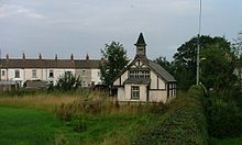 Disused timber-built, tin-roofed chapel in Dunsdale
Dunsdale is a village in the borough of Redcar and Cleveland within the civil parish of Guisborough.
History
The Newcomen family, from nearby Kirkleatham, opened an ironstone mine in Dunsdale, in 1872. It exploited two pockets of ironstone left by glaciation. The two rows of cottages forming the village of Dunsdale were part of the mine property and form the major part of the village as it is today. Traces of the drift and buildings remain with parts of the railbed in the Dunsdale area leading to the top of the incline. Unfortunately, the mine was not a particular success and was abandoned on the 31st December 1886, but the village still remains[1].
References
External links
 Media related to Dunsdale at Wikimedia Commons
Locations in the Unitary authority of Redcar and Cleveland Towns Villages Boosbeck • Boulby • Brotton • Carlin How • Charltons • Coatham • Dormanstown • Dunsdale • Easington • Handale • Kilton • Kilton Thorpe • Kirkleatham • Lazenby • Lingdale • Liverton • Margrove Park • Marske-by-the-Sea • Moorsholm • New Marske • Newton under Roseberry • Normanby • North Skelton • Ormesby • Pinchinthorpe • Scaling • Skinningrove • Stanghow • Teesville • Upleatham • Warrenby • Wilton • YearbyParish & Town Councils See also Cleveland • Greater Eston • Langbaurgh (wapentake) • Langbaurgh East • Eston Nab • Schools in Redcar and Cleveland • South Gare • Teesport • Teesside • Tees Valley
Categories:- Villages in North Yorkshire
- Locations in the Tees Valley
- Redcar and Cleveland
- Redcar and Cleveland geography stubs

Wikimedia Foundation. 2010.