- Marl, North Rhine-Westphalia
-
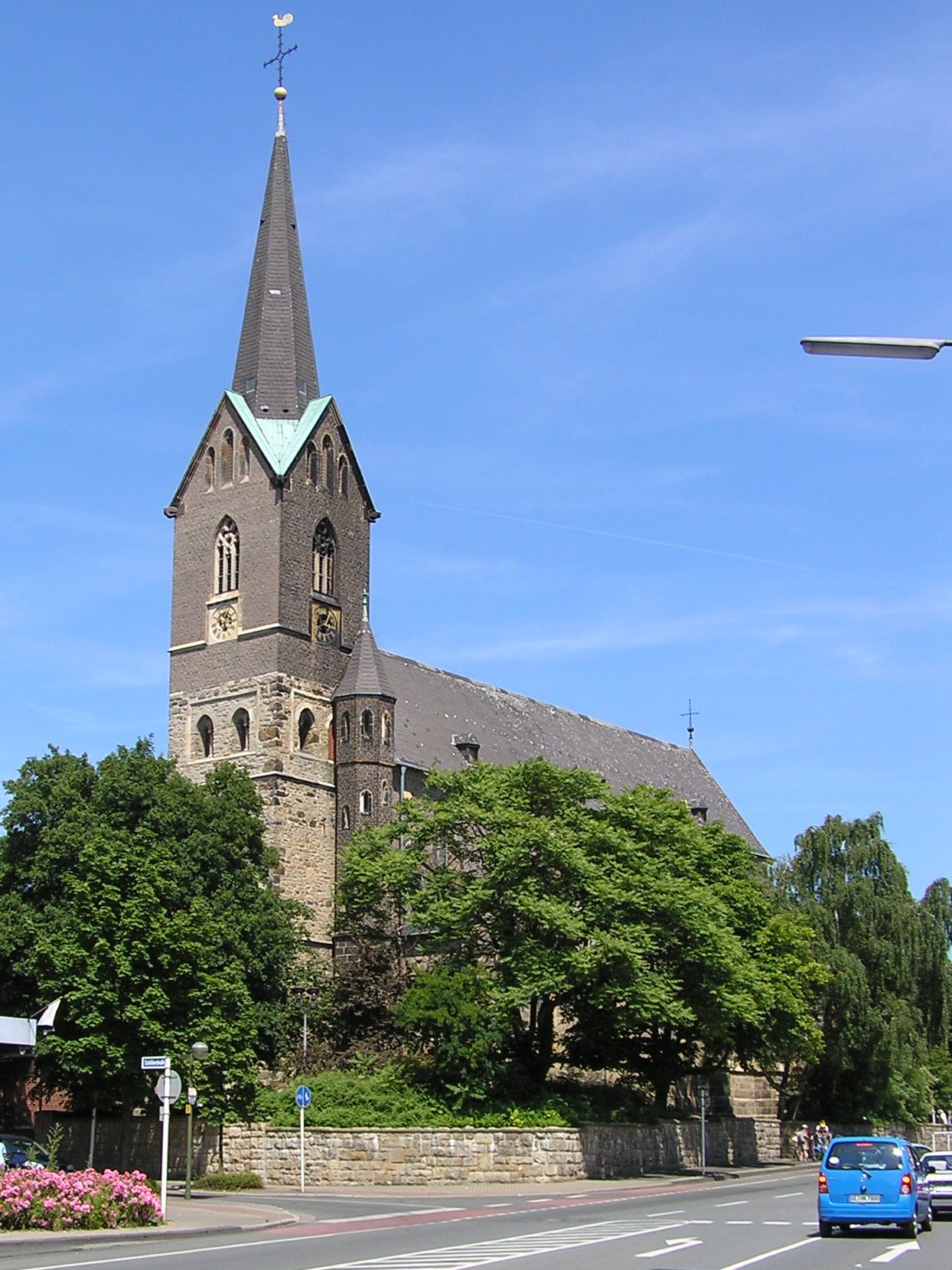
Marl Church of St. Georg in Marl


 MarlLocation of the town of Marl within Recklinghausen district
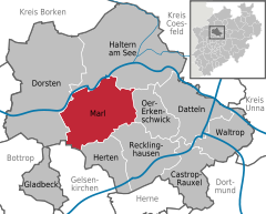

Coordinates 51°40′N 7°07′E / 51.66667°N 7.11667°ECoordinates: 51°40′N 7°07′E / 51.66667°N 7.11667°E Administration Country Germany State North Rhine-Westphalia Admin. region Münster District Recklinghausen Mayor Werner Arndt (SPD) Basic statistics Area 87.69 km2 (33.86 sq mi) Elevation 70 m (230 ft) Population 87,557 (31 December 2010)[1] - Density 998 /km2 (2,586 /sq mi) Other information Time zone CET/CEST (UTC+1/+2) Licence plate RE Postal codes 45768, 45770, 45772 Area codes 0 23 65 Website www.marl.de Marl is a town and a municipality in the district of Recklinghausen, in North Rhine-Westphalia, Germany. It is situated near the Wesel-Datteln Canal, approx. 10 km north-west of Recklinghausen. It has about 90,000 people.
Contents
- 1 Geography
- 2 History
- 3 Population
- 4 Economy
- 5 Politics
- 6 International relations
- 7 References
- 8 External links
Geography
Location
The town adjoins in the north to the woodlands of the Haard and the natural park Hohe Mark. The town forms the smooth transition between the industrial Ruhrgebiet and the rural Münsterland. The northern town border coincides nearly completely with the course of the river Lippe. Approximately 60 % of the total town area are fields, woods, watercourses, parks and other green areas.
Town area
Marl has the following urban districts:
- Stadtkern
- Alt-Marl
- Brassert
- Drewer-Nord
- Drewer-Süd
- Hamm
- Hüls-Nord
- Hüls-Süd
- Polsum
- Chemiezone
- Sinsen-Lenkerbeck
Neighbour towns
In the north Marl adjoins to Haltern am See, in the east to Oer-Erkenschwick, in the southeast to Recklinghausen, in the south to Herten, in the southwest to Gelsenkirchen and in the west to Dorsten
Nature reserves
- Braucksenke
- Die Burg (Natura 2000-area)
- Lippeau (Natura 2000-area)
- Loemühlenbachtal
History
Early History
The town area was already populated in the old and middle Stone Age, as many archeological finds in the district of Sinsen confirm. Remains of the first settlements are dated to 600 BC.
At 300 BC celtic tribes settled in the area but were expelled by invading Germanic tribes. The Brukterer controlled thereupon the area north of the river Lippe and the Marser lived south of the Lippe. The Germanic invasion was stopped by the advance of the Romans, who built a huge fort in Haltern. Remains of a smaller Roman fort were found at the city limit between Polsum and Herten.
After the Battle of the teutoburg forest in 9AC the Romans lost most of their influence and retreated behind the Rhine river. The area was again in Germanic possession.
In 80 AC the Brukterer were expelled by rival tribes and moved to the today’s area of Recklinghausen.
Early Middle Ages
The next migration movement took place in the Marl area between the 5th and 7th century, when the Saxons invaded from the northeast across the Lippe into the former Brukterer area. In the 1920th archeological excavations proofed, that the Brukterer built an circular hillfort in the district of Sinsen to defend against the Saxon attacks. Today the hillfort is only recognisable for the expert and lies in the nature reserve "Die Burg" (which means "the castle") which is named after the hillfort. Archeologists consider the hillfort as an outstanding historical monument which is worth of protection. The hillfort was used by the rural population as a protective barrier until the Late Middle Ages. Assured written regional facts about the Early Middle Ages in the 9th and 10th century were however not documented till the end of the 19th and the beginning of the 20th century.
Origin of the name
Marl was first documented in 890 in the urbarium of the benedictine abbey of Werden, which was founded in 799 during the Saxon wars. There is written, that a Dagubraht donated his possession and revenues to the abbey for his salvation. The name of Marl derives from the medieval place name "meronhlare". Linguists interpreted this name as "marshy range" or "range at a pond". The name changed over the centuries from "Marlar", "Maerl" to "Marler" and finally Marl In the urbarium are furthermore found the names of nearby settlements which later became part of the town. They were called "Threviri (Drewer)", "Vrilinctorpe(Frentrop) und "Haranni (Hamm). In addition to the Werden Abbey there were other great land owners as the Cologne and Xanten chapter, the Essen abbey and some nobles. This scattered property caused massive feuds and fighting in the Middle Ages.
Church history
In the urban district of "Alt-Marl"(Old Marl) the St.George Church is located, which belonged to the local Count Balderich of the Lower Rhine in the 11th century. Later he gave the church to the archbishop Heribert of Cologne. In a manuscript from 1160 is written, that archbishop Heribert of Cologne donated the church to the Deutz Abbey. In the 13th century it changed to a parish church when in 1228 the first priest is recorded. From 1419 the church was under the patronage of the local noble family of Loe. This lasted till 1830. Then the patronage devolved to the Baron Twickel of Lüttinghoff. From 1856 to 1859 the church was completely restored according to the construction plans of Emil von Manger, a builder of the Roman Catholic Diocese of Münster. The romanic foundation walls from the 12th century were kept.
The Counts of Loe
In the year 1111 the noble family of Loe built a castle with a moat named "Strevelsloe". In 1359 it was renamed to "Haus Loe". In official manuscripts of 1373 it was named as "castrum". In 1378 the castle was signed over as an "Offenhaus" by the owner Wessel van Loe to the Archbishop of Cologne, Frederick III. of Saarwerden. "Offenhaus" means, that in the case of war, the owner can use the castle as a stronghold. So the noble family of Loe was subject to the archbishop. The family had very many properties in the region, several farms and mills, like the "Loemill", the "Sickingmill" and the Wermeling manor at the Lippe river.
Although the Loe-family got no male successor, the name lived on as in 1585 the daughter of Wolter van Loe married her cousin Baron Dietrich of Dorneburg-Loe from Eickel.
From 1705 to 1832 the castle and all properties were passed over to the noble Family of Wiedenbrück. They sold it to the baron of Twickel, who sold it on his part to Theodor Waldhausen from Essen. 30 years later it was sold to the Duke of Arenberg, who demolished the castle. Today on the former site of the castle there is a grammar school and several sports grounds. The noble Loe-family is borne in remembrance through several names like "Loe Street", "Grammar school at the Loefield" or "Loemill-Airport".
Middle Ages and Early Modern Age
Throughout the Middle Ages Marl was involved in several wars. Between 1243 and 1384 there were many military operations between the Archbishop of Cologne and the Count of Mark among other things about the possession of the neighbor town of Recklinghausen. 1388 and 1389 Marl was involved in the "Great Dortmund feud" and in the fratricidal war between Adolf IV. of Kleve-Mark and Gerhard of the Mark from Hamm. From 1442 to 1449 Marl suffered from the "Soest feud" in which the town of Soest defended her freedom against the Archbishop of Cologne.
At the end of the 16th century Marl had 800 inhabitants. Most of them lived in the farming community of Drewer.
In the "War of the Jülich-Cleves succession", the farming communities around Marl were plundered by the Dutch and Spanish troops who joined the war. Directly following this war, the Thirty Years’ War began, where the plunderings continued. After the war, there was peace for many centuries. During the French campaign of Charles, Prince of Soubise, in the Seven Years’ War in 1758 the plundering of Marl started again. After the French troops, the Prussians came but without improvement for the situation of the inhabitants.
Until 1803 the insignificant village Marl was part of the Vest Recklinghausen. Then the Duke of Arenberg owned the village. From 1810 to 1813, during the French occupation the village was renamed in "Mairie Marl" and belonged to the Grand Duchy of Berg. After the War of the Sixth Coalition Marl got under Prussian reign and was part of the district Essen until 1816 and afterwards until now to the district Recklinghausen.
In this age, Marl had only village mayors, who were elected for one year and directly responsible to the governors of the Vest Recklinghausen. The village mayors tasks were the collection of the taxes and managing the village real estates. Beside these village mayors there were two Prince-electorial representatives, the "Amtsfron"(village soccage) and the "Amtsführer"(village leader) (from 1785 both offices were combined ) whose task was to supervise the prince-electoral regulations.
From the 1st April 1816 Marl was consolidated with the town of Dorsten to the "Office of mayor Dorsten"("Bürgermeisterei Dorsten") with the mayor of Dorsten as provost.
In 1837, after the territorial reform of the Prussian state, Marl got autonomous again. The village area was enlarged and the village of Altendorf-Ulfkotte was suburbanized, though marl did not get his name back but was named "Dorsten-environs"("Dorsten-Land") On the 31st October 1841 the Royal Administration in Münster founded the "Administration Marl" ("Amt Marl"), an in-between of town and village. The administration area included Marl, the villages of Polsum, Hamm and Altendorf-Ulfkotte, plus the surrounding farming communities.
Agriculture has always been the main source of income in Marl. This becomes apparent in an official list from 1840. The following is recorded there: 493 horses, 1879 cattle, 857 pigs, 98 goats and 4591 sheep. Despite the muchness of sheep, the importance of sheep farming declined in later centuries.
As many farmers needed a sideline, many families weaved, mostly as wageworkers for drapers. The former village mayor Bölling reports in his chronicle:
"…has built here some factories and kudos to the damask weaving mills, which deliver precious table-linen for high-standing persons and earned great reputation. It is an elegant weaving."
In the records of 1842 the following professions are listed:
3 bakers, 1 butcher, 17 shoemakers, 17 tailors, 17 carpenters, 5 cabinetmakers, 6 coopers, 1 bricklayer, 15 blacksmiths, 6 cellarmen, 60 weavers, 42 chandlers, 12 hawkers, 2 inns, 11 taverns, 6 brewer, 2 distilleries, 6 corn dealer, 5 wood dealer…
The turning point in Marls history was the 21st January 1875. On this day the "Simson well-drilling Company" found a coal deposit in the depth of 514 meter in the urban district Polsum. Additional drillings in Marl resulted in the formation coalmines.
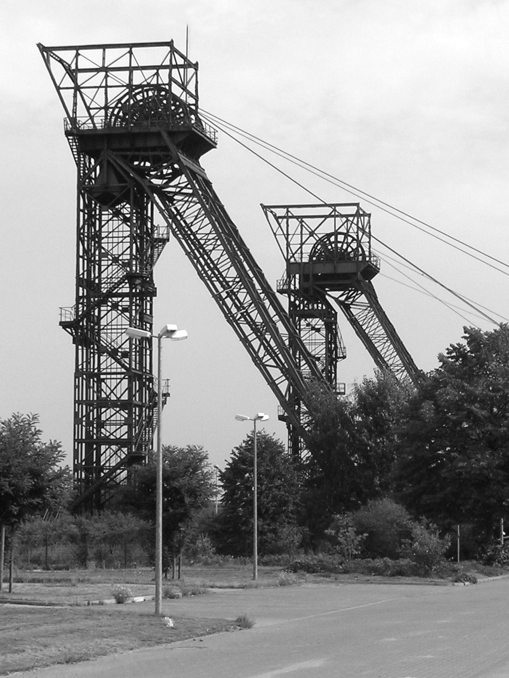
 Closed Auguste Victoria mine shafts.
Foundation of the "Auguste Victoria coalmine"
August Stein und Julius Schäfer from Düsseldorf founded the coalmine "Auguste Victoria" in 1898 based in Düsseldorf and coal production was planned on the claims "Hansi 1" and "Hansi 2". On 1 May 1900 the depths began and in 1903 the head office moved to Marls urban district Hüls. At the end of 1905 coal production began on the pit "AV 1". Eponym for the mine was Augusta Victoria of Schleswig-Holstein, (1858–1921) the last German empress and wife of Emperor Wilhelm II. Until today the coalmine is one of the highly productive mines in Germany. Nevertheless it will be closed in 2015, because of the end of the coal production in Germany.
Foundation of the "Brassert coal mine"
In 1905 another coalmine was founded in Marl. It was named after Hermann Brassert, the "father of the common mining law of 1865". In 1910 the coal production began and in the 1950s about 5,000 people were employed "on Brassert". In 1972 the mine was closed and 2/3 of the mine area became a commercial park, the other 1/3 a recreation ground. Some mining buildings have been saved. The old entrance buildings serve as an art studio and as bureau of the bicycle society. The urban district around the mine was named "Brassert" as the mine built houses around the pit for their workers.
20th century
The Spartacist Uprising, linked with the Kapp Putsch also had influence on Marl. On the 1st April 1920 the so-called "Red Ruhr Army" occupied Marl and started a gunfight with the Reichswehr at the Lippe river-crossing near Hamm-Bossendorf. 15 uninvolved channel diggers were also killed.
On 15 January 1923 Marl was occupied by French and Belgian troops.
On 1 April 1926 marl grew bigger as the surrounding villages of Sinsen, Hüls, Lenkerbeck and Löntrop were suburbanized.
In 1931 the "Handbook of all towns and villages in the Rhine province and Westpfalia" states, that Marl had 34102 inhabitants ( 19598 Roman Catholic, 12105 Protestants, 30 Jewish and 2309 other confessions) There was no mayor at that time. The city council consisted of 18 people. 10 Centre Party (Germany), 2 Social Democratic Party of Germany, 1 Reich Party of the German Middle Class, 4 Communist Party of Germany, 1 independent . The total town area was 11.076 hectare, thereof 415 hectare build-up area, 3652 hectare farmland and 5574 hectare forests and meadows.
On the 20th April 1936 marl received ist town charter by the headpresident of the province of Westphalia, Ferdinand, Baron of Lüninck.
As other town in the Ruhr district Marl is grown very fast because of the coal mines and the chemical industry
Foundation of the "Chemiepark Marl"
The "Chemical Park Marl" goes back to the foundation of the "Chemical Factories Hüls" in 1938. At the time of the Third Reich the factories produced synthetic rubber (called "Buna") for tires. Therefore a lot of forced labourers were used. After the Second World War the factories produced plastics, resources for cleaning agents and again "Buna". In 1985 the company was merged with the Degussa AG and later in 2007 with the Evonik industries an is now called "Chemical Park Marl". The infrastructure of the park was taken over by the "infracor" company.
Second World War
The Kristallnacht 1938 led to the persecution of the Jewish inhabitants, who have resided in Marl since 1910. They worked mostly in the clothing trade or sold furniture. Several people were injured, their shops burned down and all 29 Jewish inhabitants had to leave the town. Most of them were deported to Riga and murdered. These incidents were documented by the German artist Gunter Demnig and his project "Stolpersteine" (stumbling blocks).
Between 1939 and 1945 many foreign forced workers worked in companies and private households. Throughout the war especially the "Buna" factories were target of several allied air raids. Although the civilian areas of the town were relatively near to the factories civilian demolition was kept to a limit. On the 31st March 1945 the American 8th Armored Division occupied the town.
As the town was merged from several farming communities with the mining settlements and houses of the chemical workers it has no real centre. In the 1960th and 1970th a new centre was built in greenfield strategy as a new town hall, high-rise buildings and the shopping mall "Marler Stern" originated.
Population
From the mid-ages until the early 20th century Marl had just a few hundred inhabitants. The Industrialization led to a fast increase from about 2,000 people in 1900 to over 35,000 in 1939 and 92,000 in 1975. In 2007, the "Official Number of inhabitants" calculated by the Landesamt für Datenverarbeitung und Statistik of North Rhine Westphalia was 89,122. The following table shows the numbers of inhabitants. The value in 1600 is an estimate, afterwards the result of population counts or calculations of the Statistisches Landesamt. The specifications until 1871 show the "population in the area", from 1925 to 1987 they indicate the resident population and since then the main resident population. Before 1871 the means of measurement were without uniformity.
year population 1600 800 1875 1,883 1900 2,199 1910 5,571 1919 12,130 1925 16,018 1933 31,619 1939 35,288 1945 42,603 1946 44,043 1950 51,192 1956 64,228 1961 71,508 1965 76,674 1975 91,930 1985 87,449 1995 92,965 2005 90,816 2007 89,122 48.8% of the inhabitants are male, 51.2% female.
- 17.7% are less than 18,
- 34.3% are between 18 and 44,
- 21.9% are between 45 and 59,
- 26.1% are older than 60 years.
8.9% of the population are of foreign origin (Dec 2006), coming from about 130 different states. 52.5% are from Turkey, 7.5% from Ex-Yugoslavia, 5.6% from Poland.
Economy
The "Chemical Park Marl", the mine "Auguste Victoria", the "Medienhaus Bauer", are the largest employers in Marl. The coal mine at Marl-Hüls, Zeche Auguste Victoria, was founded in 1899, and is still operating. The mass production of the Low-energy vehicle Loremo was planned for 2010 in a yet-to-be-constructed car factory in the industrial complex of Dorsten/Marl, but looks now into uncertain future.[2][3]
Politics
Town Council
In the town council consists of 50 representatives of the following parties:
- SPD 19
- CDU 14
- WIR (citizen list – independent) 4
- FDP 3
- bum (citizen union – independent) 3
- Bündnis 90/Die Grünen 2
- Wählergemeinschaft ( elector community – independent) 2
- UBP (independent citizen party – independent) 1
- Die LINKE 1
On the basis of the local elections 2009.
Results of the local elections since 1975
In this chart[4][5][6][7][8] only those parties and lists are considered, which got at least 1,86 % of the total votes.
Year SPD CDU FDP GREENS1 Republikaner WIR BUM Die Linke2 UBP 1975 58,8 34,9 4,8 1979 52,8 33,6 4,3 8,9 1984 52,7 32,1 3,8 11,0 1989 48,5 28,3 4,5 11,2 7,5 19943 45,1 36,2 1,9 10,8 1,9 7,2 1999 38,4 43,8 2,5 5,0 9,5 2004 37,7 31,8 5,7 6,5 9,5 5,4 3,4 2009 36,6 27,6 6,9 7,6 8,3 5,2 5,1 2,8 1 GREENS:
- 1979 bis 2004: Voters Community (WG) Grüne,
- 2009: Voters Community 4,7 %, Bündnis 90/Die Grünen: 2,9 %
2 Linke: 2004: PDS, 2009: Linke
3 1994: FDP: 1,90 %, Republicans: 1,86 %Mayor
- 1936–1946: Friedrich Wilhelm Willeke, till 1933 Zentrum, then unknown, from 1945 CDU
- 1946–1965: Rudolf-Ernst Heiland, SPD
- 1965–1974: Ernst Immel, SPD
- 1975–1984: Günther Eckerland, SPD
- 1984–1995: Lothar Hentschel, SPD
- 1995–1999: Ortlieb Fliedner, SPD
- 1999–2009: Uta Heinrich, CDU, from 2004 independent
- 2009–2011: Werner Arndt, SPD
Chemiepark Marl
One of the largest integrated chemical production sites in Germany, the "Chemical Park Marl" is based in Marl.[9] It was founded as the Chemische Werke Hüls GmbH in 1938.
The Hüls synthetic rubber plant was a bombing target of the Oil Campaign of World War II. The second largest producer of synthetic rubber (17% of Axis supply), the plant was 240 miles closer to Allied bomber bases than the larger synthetic rubber plant at Schkopau. On June 22, 1943, the sole Eighth Air Force operation against Nazi Germany synthetic-rubber production during the first phase of the Combined Bomber Offensive opened "a new chapter in aerial warfare" (RAF Fighter Commander Sir Trafford Leigh-Mallory) with a bombing that destroying 6,200 of 8,380 built-up acres of "the city".[10]
International relations
Main article: List of twin towns and sister cities in GermanyMarl is twinned with:
 Bitterfeld, Saxony-Anhalt, Germany
 Creil, France
 Herzliya, Israel
 Zalaegerszeg, Hungary
 Pendle, United Kingdom
 Kuşadası, Turkey
References
- ^ "Amtliche Bevölkerungszahlen" (in German). Landesbetrieb Information und Technik NRW. 31 December 2010. http://www.it.nrw.de/statistik/a/daten/amtlichebevoelkerungszahlen/index.html.
- ^ Krabbe, Alexander. "Streamline Your Gas Guzzler to 1.5 Litres". OhmyNews International. http://english.ohmynews.com/articleview/article_view.asp?article_class=4&no=353383&rel_no=1. Retrieved 2007-04-02.
- ^ http://www.mindat.org/loc-17710.html
- ^ Verzeichnisse der Kommunalwahlergebnisse des Landes Nordrhein-Westfalen (LDS NRW) von 1975 bis 2009
- ^ Wahlprofil des Landesamtes für Datenverarbeitung und Statistik NW
- ^ Wahlergebnisse 1999
- ^ Wahlergebnisse 2004
- ^ Wahlergebnisse 2009
- ^ "Infracor GmbH, Operator of the Chemical Park" (in German). Infracor. http://www.infracor.de. Retrieved 7 May 2010.
- ^ Stormont, John W. (March 1946). AAFRH-19: The Combined Bomber Offensive; April through December 1943. Dwight D. Eisenhower Presidential Library: Collection of 20th Century Military Records, 1918-1950 Series I: Historical Studies Box 35: AAF Historical Office; Headquarters, Army Air Force. pp. 74–5, 81. "SECRET ... Classification Cancelled ... JUN 10 1959"
External links
- Official site (German)
- Survey map of the Chemical Park Marl (German)
Castrop-Rauxel | Datteln | Dorsten | Gladbeck | Haltern | Herten | Marl | Oer-Erkenschwick | Recklinghausen | Waltrop Categories:
- Towns in North Rhine-Westphalia
- Recklinghausen district


Wikimedia Foundation. 2010.