- Datteln
-
Datteln 
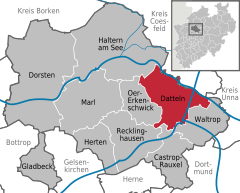
Coordinates 51°39′14″N 7°20′30″E / 51.65389°N 7.34167°ECoordinates: 51°39′14″N 7°20′30″E / 51.65389°N 7.34167°E Administration Country Germany State North Rhine-Westphalia Admin. region Münster District Recklinghausen Town subdivisions 2 Mayor Wolfgang Werner Basic statistics Area 66.08 km2 (25.51 sq mi) Elevation 49 m (161 ft) Population 35,513 (31 December 2010)[1] - Density 537 /km2 (1,392 /sq mi) Other information Time zone CET/CEST (UTC+1/+2) Licence plate RE Postal code 45711 Area codes 0 23 63 Website www.datteln.de Datteln is a town in the district of Recklinghausen, in North Rhine-Westphalia, Germany. It is situated on a crossroads of four canals (Datteln-Hamm Canal, Wesel-Datteln Canal, Dortmund-Ems Canal and Rhein-Herne Canal), which makes it the biggest canal junction in Europe, approx. 10 km north-east of Recklinghausen and 20 km north-west of Dortmund.
International relations
Main article: List of twin towns and sister cities in GermanyDatteln is twinned with:
Castrop-Rauxel | Datteln | Dorsten | Gladbeck | Haltern | Herten | Marl | Oer-Erkenschwick | Recklinghausen | WaltropReferences
- ^ "Amtliche Bevölkerungszahlen" (in German). Landesbetrieb Information und Technik NRW. 31 December 2010. http://www.it.nrw.de/statistik/a/daten/amtlichebevoelkerungszahlen/index.html.
Categories:- Towns in North Rhine-Westphalia
- Recklinghausen district
- North Rhine-Westphalia geography stubs
Wikimedia Foundation. 2010.


