- Baoshan, Yunnan
-
For other uses, see Baoshan (disambiguation).
Baoshan
保山— Prefecture-level city — 保山市 Location of Baoshan Prefecture Location within China
 Baoshan
Coordinates: 25°07′N 99°10′E / 25.117°N 99.167°E Country China Province Yunnan Admin HQ Longyang Area – Total 19,040 km2 (7,351.4 sq mi) Population – Total 2,500,000 – Density 131.3/km2 (340.1/sq mi) Postal code 678000 Area code(s) 0875 Website http://www.baoshan.gov.cn/ Yunnan e-Portal Baoshan (Chinese: 保山; pinyin: Bǎoshān) is a prefecture-level city in western Yunnan province, China.
Contents
Demography
The prefecture has about 2.5 million inhabitants.
Administrative divisions
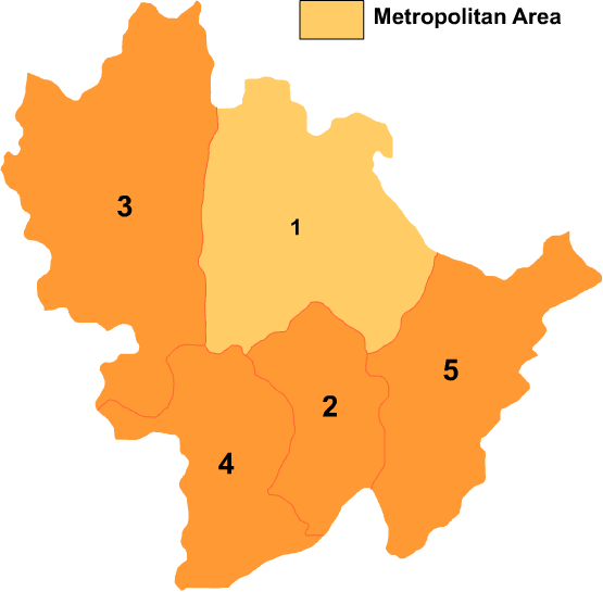
The city-prefecture of Baoshan has jurisdiction over five subdivisions - a district and four counties:
Map 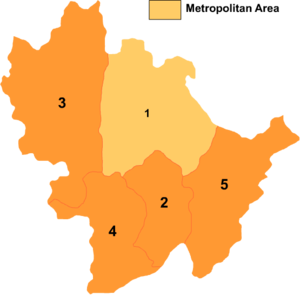
# Name Hanzi Hanyu Pinyin Population (2003 est.) Area (km²) Density (/km²) 1 Longyang District 隆阳区 Lóngyáng Qū 850,000 5,011 170 2 Shidian County 施甸县 Shīdiàn Xiàn 330,000 2,009 164 3 Tengchong County 腾冲县 Téngchōng Xiàn 610,000 5,845 104 4 Longling County 龙陵县 Lónglíng Xiàn 270,000 2,884 94 5 Changning County 昌宁县 Chāngníng Xiàn 340,000 3,888 87 Geography
It is located between the border of Myanmar and the river Mekong, in a cattle-rearing area. The Salween River (Nujiang) flows through the entire length of the prefecture, north to south.
Climate
The average temperatures for the town of Baoshan go from +9°C for the coldest month to +21,5°C for the hottest month, with an annual average of +16,3°C (figures in 1990).
Climate
Climate data for Baoshan (1971−2000) Month Jan Feb Mar Apr May Jun Jul Aug Sep Oct Nov Dec Year Average high °C (°F) 16.5
(61.7)18.0
(64.4)21.2
(70.2)23.7
(74.7)25.5
(77.9)25.5
(77.9)25.0
(77.0)25.7
(78.3)25.1
(77.2)23.4
(74.1)19.8
(67.6)17.3
(63.1)22.23
(72.01)Average low °C (°F) 1.7
(35.1)3.3
(37.9)6.1
(43.0)9.9
(49.8)14.3
(57.7)18.1
(64.6)18.2
(64.8)17.8
(64.0)16.2
(61.2)13.2
(55.8)8.0
(46.4)3.2
(37.8)10.83
(51.50)Precipitation mm (inches) 15.7
(0.618)28.4
(1.118)38.2
(1.504)45.0
(1.772)69.9
(2.752)138.4
(5.449)157.4
(6.197)172.6
(6.795)147.5
(5.807)111.4
(4.386)51.1
(2.012)12.6
(0.496)988.2
(38.906)Avg. precipitation days (≥ 0.1 mm) 3.6 6.9 8.6 12.7 12.6 18.0 21.3 21.5 16.5 12.4 6.5 3.4 144 Source: Weather China Transport
Baoshan lies on the road from Ruili to Kunming, a road partially upgraded to a four lane highway in places.
Baoshan Airport (AITA Code: BSD) has daily flights to and from Kunming. Flight time is 20 minutes.
See also
- Three Parallel Rivers of Yunnan Protected Areas - Unesco World Heritage Site
- Gaoligongshan Mountain
External links
- Baoshan City Official Site
- Baoshan Travel and Tourism Bureau (zh, en, ja)
- Baoshan News Network
- Baoshan profile
- Baoshan map
Coordinates: 25°07′N 99°10′E / 25.117°N 99.167°E
Yunnan topics General Geography Cities • Yunnan-Guizhou Plateau • Diqing Plateau • Honghe River • Dianchi Lake • Fuxian Lake • Erhai Lake • Lugu Lake • Yangzong Lake • Yilong Lake • Xi River • Yuan River • Pearl River • Red River • Pudacuo National ParkEducation Culture Music • Eighteen OdditiesCuisine Visitor attractions Categories:- Baoshan City
- Yunnan geography stubs


Wikimedia Foundation. 2010.