- Menglian Dai, Lahu and Va Autonomous County
-
Menglian County — Autonomous county — Chinese transcription(s) – Characters 孟连傣族拉祜族佤族自治县 – Pinyin Mènglián dǎizú lāhùzú wǎzú Zìzhìxiàn Location of Menglian County (pink) and Pu'er Prefecture (yellow) within Yunnan province of China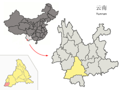 Location within Yunnan, China
 Menglian County
Coordinates: 22°18′01″N 99°25′13″E / 22.30028°N 99.42028°E Country China Province Yunnan Prefecture Pu'er GB/T 2260 CODE[1] 530827 Area – Total 1,957 km2 (755.6 sq mi) Elevation 1,300 m (4,265 ft) Population – Total 107,908 – Density 55.1/km2 (142.8/sq mi) Time zone China Standard Time (UTC+8) Postal code 665800[2] Area code(s) 0879[2] Website http://www.menglian.gov.cn/ 1Yunnan Statistics Bureau [1]
2Puer Gov. [2]
3Yunnan Portal [3]Menglian Dai, Lahu and Va Autonomous County (孟连傣族拉祜族佤族自治县; pinyin: Mènglián dǎizú lāhùzú wǎzú Zìzhìxiàn) is an autonomous county under the jurisdiction of Pu'er Prefecture, Yunnan Province, China.
References
External links
Coordinates: 22°18′01″N 99°25′13″E / 22.30028°N 99.42028°E
Categories:- County-level divisions of Pu'er City
- Yunnan geography stubs


Wikimedia Foundation. 2010.