- Mount Konocti
-
Mount Konocti 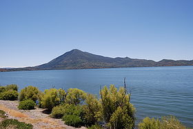
Mount Konocti as seen from Clear LakeElevation 4,305 ft (1,312 m) NAVD 88[1] Prominence 2,339 ft (713 m) [2] Location Location Lake County, California Range California Coast Ranges Coordinates 38°58′29″N 122°45′57″W / 38.9746°N 122.7659°WCoordinates: 38°58′29″N 122°45′57″W / 38.9746°N 122.7659°W[1] Topo map USGS Kelseyville Geology Type Lava dome [3] Age of rock About 350,000 years Volcanic arc/belt Clear Lake Volcanic Field Mount Konocti (/kɵˈnɒktaɪ/) is a volcano in Lake County, California on the south shore of Clear Lake. At 4,305 feet (1,312 m), it is the second highest peak in the Clear Lake Volcanic Field, which consists of numerous volcanic domes and cones ranging from 10,000 to 2.1 million years old.
Contents
Geography
The volcano is the most visible landmark in Lake County other than the lake. The mountain is located between the towns of Lakeport and Clearlake. It lies directly south of Soda Bay and Riviera Heights and east of Kelseyville. From the summit of Mount Konocti, the taller peaks and ridges around Snow Mountain can be seen to the northeast.
Mount Konocti has five distinctive peaks: Wright Peak (4,299 feet / 1,310 metres), Howard Peak (4,286 feet / 1,306 metres), South Peak (4,286 feet / 1,306 metres), Buckingham Peak (3,967 feet / 1,209 metres) and Clark Peak (2,880 feet / 880 metres). Wright Peak, Howard Peak, and South Peak make up the main part of the mountain, while Buckingham Peak and Clark Peak are located off to the side. Konocti Road runs about 4 miles (6.4 km) west from the Taylor Planetarium & Observatory in the town of Kelseyville, snaking between Howard and South Peaks and ending at the mountain's summit, Wright Peak.
Benson Ridge lies to the south of Clark Peak and west of South Peak. Buckingham Peak lies north of Howard and Wright Peaks and northeast of Clark Peak. South Peak is directly south of Howard Peak and southwest of Wright Peak. Wright Peak lies east and a little north of Howard Peak.
History
Mount Konocti probably first erupted some 350,000 years ago and last erupted 10,000 years ago. Clear Lake is much older and is possibly the oldest securely dated lake in North America. Core samples taken by U.S. Geological Survey geologists in 1973 and 1980 have been dated to 480,000 years.
Archaeologists have found evidence that native people, principally Pomo people and Wappo, have inhabited the area around Konocti for as much as 11,000 years. The name "Konocti" is derived from the Pomo "kno", mountain, and "htai", woman. [4]
The mountain is covered with heavy concentrations of chaparral similar to the European maquis shrubland. Oak, Pacific madrone, manzanita, western white pine and other plant species of the California coastal mountains dominate the area. On the northeast slope of Mount Konocti is a steep, heavily forested area known locally as the "Black Forest", because it never gets direct sunshine. The Black Forest contains heavy stands of Douglas fir.
Local people have long known that Konocti is riddled with natural caves. Although most of the natural caves collapsed or were filled in for safety in the early 20th century, persistent local belief holds that Konocti's central magma chamber is a vast, empty vertical cavern, partly filled with Clear Lake water and connecting with the lake via an underground seep. This cavern might be the largest on Earth, though its existence is difficult to prove due to the unstable and eroding structure of the volcano's cone. Heavy vegetation also conceals cave entrances. No accurate map or survey of the caves has been created due to the heavy underbrush and unstable hillsides. The majority of Konocti is owned by private parties, who have discouraged exploration and study of the mountain in recent years. The County of Lake recently purchased 1,520 acres on top of the mountain. As a result, Mt. Konocti County Park opened to the public on September 24, 2011.[5]
Pomo legend has it that around the year 1818, after a long drought, the level of Clear Lake dropped so low that a previously-unknown cave on the eastern flank of Konocti was exposed. A group of Pomo men entered the cave, and discovered a vast underground lake, containing "eyeless fish". Repeated attempts by divers to locate this cave have been unsuccessful.
References
- ^ a b "Konocti". NGS data sheet. U.S. National Geodetic Survey. http://www.ngs.noaa.gov/cgi-bin/ds_mark.prl?PidBox=JT2725. Retrieved 2009-07-01.
- ^ "Mount Konocti, California". Peakbagger.com. http://www.peakbagger.com/peak.aspx?pid=1177. Retrieved 2009-07-01.
- ^ "Clear Lake: Synonyms and Subfeatures". Global Volcanism Program, Smithsonian Institution. http://www.volcano.si.edu/world/volcano.cfm?vnum=1203-10-&volpage=synsub. Retrieved 2009-08-17.
- ^ Carl, Guy (May 12, 2011). "The legend of Mount Konocti". Napa Valley Register (Napa, CA: Lee Enterprises, Inc.). http://napavalleyregister.com/sports/columnists/guy-carl/the-legend-of-mount-konocti/article_17b8eb10-7d25-11e0-906b-001cc4c002e0.html. Retrieved September 30, 2011.
- ^ http://www.lakecounty.com/AboutLC/Explore/Konocti.htm Retrieved October 29, 2011.
Further reading
- Wood, Charles A.; Jürgen Kienle, eds. (1990). Volcanoes of North America. Cambridge University Press. ISBN 0-521-43811-X.
- Locke, Juliane Poirier (2004). "Forgotten Lake". California Wild. California Academy of Sciences. Archived from the original on 2006-10-06. http://web.archive.org/web/20061006102537/http://www.calacademy.org/calwild/2004spring/stories/clearlake.html. Retrieved 2007-03-09. Article about Clear Lake and Mt. Konocti
- Richerson, Peter J.; Richerson, Scott O. (2000). "The Ample Charms of a Well-Fed Lake". http://www.des.ucdavis.edu/faculty/Richerson/AmpleCharms.pdf. Retrieved 2007-03-09. Extensive article about the Clear Lake area
External links
- "Mount Konocti". Geographic Names Information System, U.S. Geological Survey. http://geonames.usgs.gov/pls/gnispublic/f?p=gnispq:3:::NO::P3_FID:254859. Retrieved 2009-08-17.
- "Mount Konocti". Top of Konocti - Mount Konocti land owners.. http://www.topofkonocti.com/mount_konocti.asp. Retrieved 2009-08-17.
- "PreserveKonocti.org". http://www.preservekonocti.org/. Retrieved 2010-10-22.
Categories:- Stratovolcanoes
- Landforms of Lake County, California
- Volcanoes of California
- Native American mythology of California

Wikimedia Foundation. 2010.