- Mound Township, Warren County, Indiana
-
Mound Township — Township — Location of Mound Township in Warren County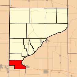 Location of Warren County in Indiana
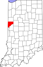
Coordinates: 40°08′52″N 87°28′12″W / 40.14778°N 87.47°WCoordinates: 40°08′52″N 87°28′12″W / 40.14778°N 87.47°W Country United States State Indiana County Warren Government – Type Indiana township Area – Total 16.79 sq mi (43.48 km2) – Land 16.57 sq mi (42.93 km2) – Water 0.21 sq mi (0.55 km2) 1.26% Elevation 633 ft (193 m) Population (2000) – Total 438 – Density 26.4/sq mi (10.2/km2) Time zone Eastern (EST) (UTC-5) – Summer (DST) EDT (UTC-4) GNIS feature ID 0453656 Mound Township is one of twelve townships in Warren County, Indiana, USA. As of the 2000 census, its population was 438.[1]
Contents
History
Mound Township was one of the original four created when the county was organized in 1827.[2]
Geography
Mound Township covers an area of 16.79 square miles (43.5 km2); of this, 0.21 square miles (0.54 km2) or 1.26 percent is water. The town of Foster is located just north of U.S. Route 136, about 1 mile (1.6 km) east of the township's southwestern border. The town of Baltimore thrived on the on the banks of the Wabash River in the early 19th century, but it no longer exists. The streams of Kitchen Creek and Possum Run run through this township.
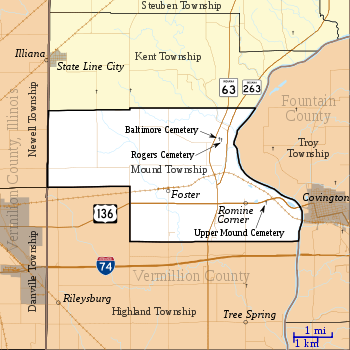 Map of Mound Township
Cemeteries
The township contains these three cemeteries: Baltimore,[3] Rogers[4] and Upper Mound.[5]
Transportation
U.S. Route 136 runs across the south part of the township, connecting Danville, Illinois to the west with Covington to the east.[6] Indiana State Road 63 runs from north to south in the eastern part of the township;[7] its child route of Indiana State Road 263 joins State Road 63 just north of the intersection with U.S. Route 136.[8] Meade Airport is located in this township.
Education
Mound Township is part of the Metropolitan School District of Warren County.[9]
Government
Mound Township has a trustee who administers rural fire protection and ambulance service, provides poor relief, manages cemetery care, and performs farm assessment, among other duties. The trustee is assisted in these duties by a three-member township board. The trustees and board members are elected to four-year terms.[10]
Mound Township is part of Indiana's 8th congressional district, Indiana House of Representatives District 42,[11] and Indiana State Senate District 38.[12]
References
- ^ United States Census Bureau American FactFinder
- ^ Warren County Historical Society 1966, p. 56.
- ^ "Baltimore Cemetery". Geographic Names Information System, U.S. Geological Survey. http://geonames.usgs.gov/pls/gnispublic/f?p=gnispq:3:::NO::P3_FID:430468. Retrieved 2011-02-05.
- ^ "Roger Cemetery". Geographic Names Information System, U.S. Geological Survey. http://geonames.usgs.gov/pls/gnispublic/f?p=gnispq:3:::NO::P3_FID:442243. Retrieved 2011-02-05.
- ^ "Upper Mound Cemetery". Geographic Names Information System, U.S. Geological Survey. http://geonames.usgs.gov/pls/gnispublic/f?p=gnispq:3:::NO::P3_FID:445169. Retrieved 2011-02-05.
- ^ "U.S. Route 136". Highway Explorer. http://www.highwayexplorer.com/EndsPage.php?id=2136§ion=1. Retrieved 2010-09-21.
- ^ "State Road 63". Highway Explorer. http://www.highwayexplorer.com/EndsPage.php?id=1063§ion=1. Retrieved 2010-09-21.
- ^ "State Road 263". Highway Explorer. http://www.highwayexplorer.com/EndsPage.php?id=1263§ion=1. Retrieved 2010-09-21.
- ^ "Corporation Snapshot, M S D Warren County #8115". Indiana Department of Education. http://mustang.doe.state.in.us/SEARCH/snapcorp.cfm?corp=8115. Retrieved 2011-01-27.
- ^ "Government". United Township Association of Indiana. http://unitedtownships.org/?page_id=95. Retrieved 2011-01-06.
- ^ "Indiana Senate Districts" (GIF). Stats Indiana. http://www.stats.indiana.edu/maptools/maps/boundary/legislative/state%20senate%20districts.gif. Retrieved 2011-01-23.
- ^ "Indiana House Districts" (GIF). Stats Indiana. http://www.stats.indiana.edu/maptools/maps/boundary/legislative/state%20house%20districts.gif. Retrieved 2011-01-23.
- "Mound Township, Warren County, Indiana". Geographic Names Information System, U.S. Geological Survey. http://geonames.usgs.gov/pls/gnispublic/f?p=gnispq:3:::NO::P3_FID:0453656. Retrieved 2009-09-24.
- United States Census Bureau TIGER/Line Shapefiles
Bibliography
- Goodspeed, Weston A. (1883). "Part II. History of Warren County". Counties of Warren, Benton, Jasper and Newton, Indiana. Chicago: F. A. Battey and Company. pp. 31–156. http://www.archive.org/stream/cu31924028850010#page/n33/mode/2up. Retrieved 2010-09-19.
- Clifton, Thomas, ed (1913). Past and Present of Fountain and Warren Counties Indiana. Indianapolis: B. F. Bowen and Company. pp. 201–335. http://www.archive.org/stream/pastpresentoffou01clif#page/346/mode/2up. Retrieved 2010-09-19.
- Warren County Historical Society (1966). A History of Warren County, Indiana. Williamsport, Indiana.
- Warren County Historical Society (2002). A History of Warren County, Indiana (175th Anniversary Edition). Williamsport, Indiana.
External links

Newell Township, Vermilion County, Illinois Kent Township Danville Township, Vermilion County, Illinois 
Troy Township, Fountain County  Mound Township

Highland Township, Vermillion County Municipalities and communities of Warren County, Indiana Towns 
Townships Unincorporated
communitiesCarbondale | Foster | Green Hill | Hedrick | Independence | Johnsonville | Judyville | Kramer | Marshfield | Pence | Rainsville | Stewart | Tab | Winthrop
Ghost towns Baltimore | Brisco | Chatterton | Chesapeake | Dresser | Kickapoo | Locust Grove | Point Pleasant | Sloan | Walnut Grove | Warrenton
Categories:- Townships in Warren County, Indiana
- 1827 establishments in the United States
- Populated places established in 1827


Wikimedia Foundation. 2010.