- Florida State Road 20
-
"FL 20" redirects here. For the congressional district, see Florida's 20th congressional district.
State Road 20
Route information Maintained by FDOT Length: 347.89 mi[1] (559.87 km) Major junctions West end:  SR 85 in Niceville
East end: 

 US 1/SR 5/SR 100 in Bunnell
Highway system Florida State and County Roads
Interstate • US • SR (Pre-1945) • Toll • County←  SR 19
SR 19SR 21  →
→State Road 20 is an east–west route across northern Florida and the Florida Panhandle.
Contents
Route description
The western terminus of State Road 20 is at State Road 85 in Niceville. The route proceeds east through Blountstown, crossing the Apalachicola River on the Trammell Bridge, then proceeding though the Apalachicola National Forest and Tallahassee. It then becomes a hidden route briefly along US 90 in Tallahassee, then along US 27 in Tallahassee where it joins the Apalachee Parkway, a major east-west thoroughfare in the city. Constructed in 1957, the Apalachee Parkway starts at Monroe Street in front of the Florida State Capitol building. It has a short expressway section just east of the capitol, then is a busy four-lane surface boulevard with service roads for the next few miles, passing the Governor's Square Mall and many state office buildings.After the Parkway ends, SR 20 remains a hidden route along US 27 as they run through Capps, Florida, where US 19 joins US 27 until they reach Perry where US 19 continues south towards the Tampa Bay Metropolitan Area, while US 27-SR 20 run east to High Springs.
After a brief signed portion in High Springs, State Road 20 is again hidden along US 441 to Gainesville, where it becomes a stand-alone route along Northwest 6th Street, then turns east onto Northwest 8th Avenue, until running south again onto North Main Street before it overlaps such roads as SR 24 and 26. East of Gainesville, the road again becomes a stand-alone route that is four lanes wide as it runs through Lochloosa Wildlife Conservation Area to the interchange with US 301 in Hawthorne. The road has since been widened along the route between Interlachen and Francis[2] as it heads into Palatka, finally (and, again, "secretly") joining with State Road 100 to a terminus at US 1 in Bunnell.Related route
County Road 120
Location: Liberty / Leon County Line 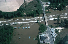 Aerial view of the Ochlockonee River in flood on April 16, 1975 near Bloxham, at the old Florida State Highway 20 bridge crossing and just southwest of the Talquin Dam.
Liberty County Road 120 (CR 120) is a short piece of an old alignment of State Road 20, at the Liberty/Leon County Line. CR 120 only extends a couple of tenths of a mile (about 300 m) to the Ochlockonee River, where the old bridge has been dismantled; thus, it no longer connects, to Leon County CR 20, on the other side of the river.
The main reasons for a realignment were to straighten out the curve on the Leon County side and to bypass a residential area. Along CR 120, are entrances to a couple of residences and an abandoned gas station.
References
External links
Categories:- State highways in Florida
- State Roads in Okaloosa County, Florida
- State Roads in Walton County, Florida
- State Roads in Washington County, Florida
- State Roads in Bay County, Florida
- State Roads in Calhoun County, Florida
- State Roads in Liberty County, Florida
- State Roads in Leon County, Florida
- State Roads in Jefferson County, Florida
- State Roads in Madison County, Florida
- State Roads in Taylor County, Florida
- State Roads in Lafayette County, Florida
- State Roads in Suwannee County, Florida
- State Roads in Columbia County, Florida
- State Roads in Alachua County, Florida
- State Roads in Gainesville, Florida
- State Roads in Putnam County, Florida
- State Roads in Flagler County, Florida


Wikimedia Foundation. 2010.