- Laytown
-
Laytown
an Inse— Town — Location in Ireland
 Laytown
Coordinates: 53°40′23″N 6°14′22″W / 53.673121°N 6.239548°WCoordinates: 53°40′23″N 6°14′22″W / 53.673121°N 6.239548°W Country Ireland Province Leinster County County Meath Elevation 0 m (0 ft) Population (2002) – Rural 2,007 Time zone WET (UTC+0) – Summer (DST) IST (WEST) (UTC-1) Irish Grid Reference O162714 Historical populations Year Pop. ±% 1831 587 — 1841 317 −46.0% 1851 333 +5.0% 1861 68 −79.6% 1901 112 +64.7% 1936 258 +130.4% 1946 401 +55.4% 1951 411 +2.5% 1956 1,117 +171.8% 1961 1,034 −7.4% 1966 1,339 +29.5% 1971 1,882 +40.6% 1981 2,997 +59.2% 1986 3,321 +10.8% 1991 3,360 +1.2% 1996 3,678 +9.5% 2002 5,597 +52.2% 2006 8,978 +60.4% [1] 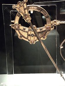 Tara Brooch, front view.
Laytown is a village on the R150 regional road on the Irish Sea coast of County Meath, Ireland. Historically it was called Ninch[2] (Irish: an Inse, meaning "the holm"), after the townland it occupies.[3] Together with the neighbouring villages of Mornington and Bettystown it comprises the census town of Laytown-Bettystown-Mornington.
Contents
History
The surrounding area is known to have been settled for around 1500 years; recent excavations have revealed settlement at Laytown since at least the 6th century AD.
Archaeological finds
- On the famous beach at Bettystown, one of the biggest historical finds in Irish history was made. In 1850 a peasant woman claimed (rather implausibly) to have found the Tara Brooch in a box buried in the sand. Many think it was in fact found inland and the claim was made to avoid a legal claim by the landowner of the actual find site, wherever that was. The Tara Brooch is now on display in the National Museum of Ireland in Dublin.
- An archeological dig in 2000 revealed early Christian graves of around 50 people and a Bronze Age enclosure. Artefacts recovered include a Hiberno-Norse ring pin, though this may signify mere contact or trade with Vikings rather than their actual presence in the area.[1]
- A blue glass bead of the early Christian period was found at the rath at Ninch West associated in legend with Laeg mac Riangabra, Cuchulain’s charioteer, from whom Laytown is said to take its name.
- The mound at The Ninch said to be the tomb of Lay was excavated in 1982/3 by Prof. Sweetman and found to contain two Iron Age interments [2]
Geography
Laytown is 50 km (30 mi) north of the nation's capital, Dublin. Laytown and neighboring town, Bettystown, sit on one of Ireland's most scenic beachfronts. The beach stretches from Mornington at the River Boyne, which borders County Louth to Gormanston at the River Delvin, which borders County Dublin.
Laytown sits on the mouth of the River Nanny, a tidal estuary where mullet, trout, eels, gobies and flounder can be caught - but no salmon. According to local folklore, Saint Patrick banished all the salmon from the river. By an old schoolhouse overlooking the river there is a spring known as St Patrick's Well, though the access path to it is overgrown.
Buildings of note
Many of Laytown's larger buildings, including the train station master's house and the large terrace homes facing onto the beach were built in the mid-nineteenth century. [3] The architecture of the Church of the Sacred Heart is of particular note: the facade is retained from the original nineteenth century, but the main building is a 1970s circular-plan single room with a large window overlooking the Irish Sea. On the hill behind the window is a twenty-foot wooden cross. [4]
Transport & communications
The village has become well established as a commuter town for people working in Dublin, fuelled by the completion of the M1 motorway linking the north east of the country to the capital. The village is served by the Northern commuter train line linking Drogheda and Dundalk to Connolly station in Dublin. Laytown railway station opened on 25 May 1844[4] and was renamed as Laytown & Bettystown in 1913. An express coach service links Laytown, Bettystown and Sonairte with Parnell Street in Dublin.
Amenities
The town has a garda station and a primary school and Gaelscoil. Coláiste na hInse in Laytown has been given the go ahead to go to tender for 1,000 pupils with a special needs unit. The village also consists of three pubs, two newsagents, a pharmacy, two take-aways and a train station.
Sonairte: The National Ecology Centre, is half a mile from the station on the Dublin road. [5]
Laytown on film
Both Irish and American movies (The Crying Game and Michael Collins) and television shows have been filmed all over Laytown, mostly on the beach.
Laytown today
Laytown was once a tiny coastal village, but in the past decade, the town has seen both a huge population and economic boom. With the ever developing and growing city of Dublin, Laytown, along with other villages and towns all along the east coast, has recorded a population boom. This has brought problems with overcrowded schools. [6]
Laytown races
Since 1876 Laytown has hosted a single annual horse racing meeting on its beach - one of only a couple of sand (held on the beach) race meetings run under official rules of racing in Europe. The BBC have made it the subject of a documentary, titled Racing the Tide, and have included passages in their Coast and Countryfile programmes.
See also
External links
- Laytown pictures on FlickR
- Laytown races official website
- Laytown & Bettystown Golf Club
- Meath Event Guide
- Sonairte Ecology Centre
References
- ^ http://www.cso.ie/census and http://www.histpop.org. Figures include totals for Mornington, listed separately until 1971, and Donnycarny, listed separately until 1851. No census town was recorded in the census years of 1871, 1881, 1891, 1911 and 1926 as there was no cluster of twenty inhabited houses. Separate hamlets of Baymore (population 123) and Colpe (population 71) were recorded in 1831. For a discussion on the accuracy of pre-famine census returns see JJ Lee “On the accuracy of the pre-famine Irish censuses” in Irish Population, Economy and Society edited by JM Goldstrom and LA Clarkson (1981) p54, and also “New Developments in Irish Population History, 1700-1850” by Joel Mokyr and Cormac Ó Gráda in The Economic History Review, New Series, Vol. 37, No. 4 (Nov., 1984), pp. 473-488.
- ^ Placenames Database of Ireland: Laytown (see archival records)
- ^ Placenames Database of Ireland: Ninch
- ^ "Laytown and Bettystown station". Railscot - Irish Railways. http://www.railscot.co.uk/Ireland/Irish_railways.pdf. Retrieved 6 September 2007.
Places in County Meath Towns 
Villages
and townlands- Ardcath
- Agher
- Baile Ghib
- Batterstown
- Bective
- Bellewstown
- Bettystown
- Boyerstown
- Carnaross
- Clonard
- Clonee
- Curraha
- Donacarney
- Drumconrath
- Drumone
- Drumree
- Duleek
- Enfield
- Gormanston
- Julianstown
- Kentstown
- Kilcloon
- Kildalkey
- Kilmainhamwood
- Kilmessan
- Kiltale
- Laytown
- Longwood
- Monknewton
- Mornington
- Mosney
- Moylagh
- Moynalty
- Mulhussey
- Nobber
- Ráth Cairn
- Rathmolyon
- Skryne
- Slane
- Stamullen
- Summerhill
- Yellow Furze
- Category:Geography of County Meath
Categories:- Towns and villages in County Meath
- Horse racing venues in the Republic of Ireland
- Beaches of the Republic of Ireland
- Drogheda
- National Monuments in County Meath


Wikimedia Foundation. 2010.